Queensway tube station

Last updated

Queensway Underground no-text.svg
Queensway tube station.jpg
Open street map central london.svg
Red pog.svg
Queensway
Location of Queensway in Central London
Location Bayswater
Local authority Westminster
Managed by London Underground
Station codeQUE [1]
Number of platforms2
Fare zone 1
OSI Bayswater Underground no-text.svg [2]
London Underground annual entry and exit
2017Decrease2.svg 8.52 million [3]
2018Decrease2.svg 8.44 million [4]
2019Decrease2.svg 8.25 million [5]
2020Decrease2.svg 2.12 million [6]
2021Increase2.svg 3.62 million [7]
Railway companies
Original company Central London Railway
Key dates
30 July 1900Opened as Queen's Road
1 September 1946Renamed Queensway
Other information
External links
WGS84 51°30′37.6″N0°11′14″W / 51.510444°N 0.18722°W / 51.510444; -0.18722 Coordinates: 51°30′37.6″N0°11′14″W / 51.510444°N 0.18722°W / 51.510444; -0.18722
Underground sign at Westminster.jpg  London transportportal

Queensway is a London Underground station on the Central line in Bayswater, just inside the boundary of the City of Westminster with the Royal Borough of Kensington and Chelsea. It is at the junction of Queensway and Bayswater Road, and is opposite the north-west corner of Kensington Gardens. It is between Notting Hill Gate to the west and Lancaster Gate to the east, and is in Travelcard Zone 1.

Contents

History

It opened on 30 July 1900, as Queen's Road, and was renamed on 1 September 1946. The building is an unusual survivor of the buildings designed for the Central London Railway by Harry Bell Measures, with a flat roof so that commercial development could take place above – in this case, a hotel. The Coburg hotel opened in 1907: its design features three cupolas, over shops and Queensway station. [12]

The station today

There is a crossover east of the station to allow trains to terminate there. The crossover is not often used.

Refurbishment

The station was closed between 8 May 2005 and 14 June 2006 for refurbishment. These works were prompted by the need to replace the station's two (very old) lifts, which had been breaking down quite frequently prior to the station's closure. In addition the station had been modernised and re-tiled, as well as having replicas of the original lamps fitted to the façade.

Metronet, the private maintenance contractors, were originally given a deadline of 9 May 2006 to complete the works. When they failed to meet this or the revised 12 June deadline, Transport for London issued a harshly worded press release quoting London Underground Managing Director Tim O'Toole as saying "This is a further, and one hopes final, pathetic delay on a project that Metronet has failed to manage to time." [13] The station finally re-opened on 14 June 2006. [14]

During refurbishment, the closest station was Bayswater on the Circle and District lines, which is also located on Queensway approximately 100 metres north of the Queensway station. While the two stations are in close proximity, they are not connected.

Connections

London Buses routes 70, 94, 148 and night route N207 serve the station. [15] [16]

Related Research Articles

<span class="mw-page-title-main">Notting Hill Gate tube station</span> London Underground station

Notting Hill Gate is a London Underground station near Notting Hill, London, located on the street called Notting Hill Gate. On the Central line, it is between Holland Park to the west and Queensway to the east. On the District line and Circle line, it is between High Street Kensington and Bayswater stations. It is on the boundary of Travelcard Zone 1 and Zone 2.

<span class="mw-page-title-main">Bayswater tube station</span> London Underground station

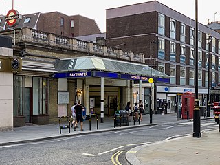
Bayswater is a London Underground station in the Bayswater area of the City of Westminster. The station is on the Circle and District lines, between Notting Hill Gate and Paddington stations and is in Travelcard Zone 1. It is less than 100 metres (330 ft) away from the Central line's Queensway station.

<span class="mw-page-title-main">South Kensington tube station</span> London Underground station

South Kensington is a London Underground station in the district of South Kensington, south west London. It is served by the District, Circle and Piccadilly lines. On the District and Circle lines it is between Gloucester Road and Sloane Square, and on the Piccadilly line between Gloucester Road and Knightsbridge. It is in Travelcard Zone 1. The main station entrance is located at the junction of Old Brompton Road (A3218), Thurloe Place, Harrington Road, Onslow Place and Pelham Street. Subsidiary entrances are located in Exhibition Road giving access by pedestrian tunnel to the Natural History, Science and Victoria and Albert Museums. Also close by are the Royal Albert Hall, Imperial College London, the Royal College of Music, the London branch of the Goethe-Institut and the Ismaili Centre.

<span class="mw-page-title-main">Bond Street station</span> London Underground and Elizabeth line station

Bond Street is a London Underground and Elizabeth line station in Mayfair, in the West End of London. Entrances are on Oxford Street, near its junction with New Bond Street, and on Hanover Square.

<span class="mw-page-title-main">Edgware Road tube station (Circle, District and Hammersmith & City lines)</span> London Underground station on the Circle, District and Hammersmith & City lines

Edgware Road is a London Underground station on the Circle, District and Hammersmith & City lines, located on the corner of Chapel Street and Cabbell Street, within Travelcard zone 1. A separate station of the same name but served by the Bakerloo line is located about 150 metres away on the opposite side of Marylebone Road.

<span class="mw-page-title-main">Hammersmith tube station (District and Piccadilly lines)</span> London Underground station

Hammersmith is a London Underground station in Hammersmith. It is on the District line between Barons Court and Ravenscourt Park, and on the Piccadilly line between Barons Court and Acton Town or Turnham Green at very early morning and late evening hours. The station is in Travelcard Zone 2.

<span class="mw-page-title-main">High Street Kensington tube station</span> London Underground station

High Street Kensington is a London Underground station on Kensington High Street, in Kensington. The station is on the Circle line between Gloucester Road and Notting Hill Gate, and the District line between Earl's Court and Notting Hill Gate and is in Travelcard Zone 1. Kensington Arcade forms the entrance to the station.

<span class="mw-page-title-main">Lancaster Gate tube station</span> London Underground station

Lancaster Gate is a London Underground station located on the Central line near Lancaster Gate on Bayswater Road in Paddington, to the north of Kensington Gardens. It is between Queensway and Marble Arch on the Central line and is in Travelcard Zone 1.

<span class="mw-page-title-main">Mansion House tube station</span> London Underground station

Mansion House is a London Underground station in the City of London which takes its name from Mansion House, the residence of the Lord Mayor of London. It opened in 1871 as the eastern terminus of the Metropolitan District Railway. Today, Mansion House is served by the Circle and District lines. It is between Blackfriars and Cannon Street stations and it is in fare zone 1. The station is located at the junction of Queen Victoria Street and Cannon Street.

<span class="mw-page-title-main">Sloane Square tube station</span> London Underground station

Sloane Square is a London Underground station in Chelsea, serving Sloane Square. It is served by the District and Circle lines, between South Kensington and Victoria stations and is in Travelcard Zone 1.

<span class="mw-page-title-main">Dagenham East tube station</span> London Underground station

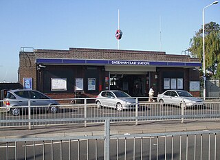
Dagenham East is a London Underground station located on the eastern side of the town of Dagenham in the London Borough of Barking and Dagenham, east London. It is on the District line between Dagenham Heathway to the west and Elm Park to the east. It is 6.4 kilometres (4.0 mi) along the line from the eastern terminus at Upminster and 27.8 kilometres (17.3 mi) to Earl's Court in central London where the line divides into numerous branches. The station has moderate usage for a suburban station, with approximately 3 million exits/entrances per year.

<span class="mw-page-title-main">Mile End tube station</span> London Underground station

Mile End is a London Underground station in Mile End, London. It is served by the Hammersmith & City, District and Central lines. This station features a cross-platform interchange in both directions, District and Hammersmith & City lines stopping on the inside tracks and the Central line stopping on the outside tracks. It is in Travelcard Zone 2.

<span class="mw-page-title-main">Hornchurch tube station</span> London Underground station

Hornchurch is a London Underground station serving the town of Hornchurch in the London Borough of Havering, east London. It is on the District line between Elm Park to the west and Upminster Bridge to the east. It is 2.5 kilometres (1.6 mi) along the line from the eastern terminus at Upminster and 31.7 kilometres (19.7 mi) to Earl's Court in central London where the line divides into numerous branches.

<span class="mw-page-title-main">Latimer Road tube station</span> London Underground station

Latimer Road is a London Underground station in North Kensington, in the Royal Borough of Kensington and Chelsea. It is on the Circle and Hammersmith & City lines between Wood Lane and Ladbroke Grove stations and is in Travelcard Zone 2.

<span class="mw-page-title-main">Westbourne Park tube station</span> London Underground station

Westbourne Park is a London Underground station in the Notting Hill area of the Royal Borough of Kensington and Chelsea. It is on the Circle and Hammersmith and City lines, between Ladbroke Grove and Royal Oak stations, and is in Travelcard Zone 2.

<span class="mw-page-title-main">Greenford station</span> London Underground & National Rail station

Greenford is a London Underground and National Rail station in Greenford, Greater London, and is owned and managed by London Underground. It is the terminus of the National Rail Greenford branch line, 2 miles 40 chains down the line from West Ealing and 9 miles 6 chains measured from London Paddington. On the Central line, it is between Perivale and Northolt stations while on National Rail, the next station to the south on the branch is South Greenford.

<span class="mw-page-title-main">Gunnersbury station</span> London Underground and London Overground station

Gunnersbury is a London Overground and London Underground station in Gunnersbury in London, England on the North London line. The station opened on 1 January 1869 and is served by District line trains to and from Richmond, and by Arriva Rail London on the London Overground network. On the District line the station is between Turnham Green and Kew Gardens, and on the North London line it is between South Acton and Kew Gardens.

<span class="mw-page-title-main">Ladbroke Grove tube station</span> London Underground station

Ladbroke Grove is a London Underground station on the Circle and Hammersmith & City lines, between Latimer Road and Westbourne Park stations, and in Travelcard Zone 2 set in The Royal Borough of Kensington and Chelsea.

<span class="mw-page-title-main">West Kensington tube station</span> London Underground station

West Kensington is a London Underground District line station in West Kensington. It is located on North End Road (B317) close to its junction with West Cromwell Road/Talgarth Road (A4).

<span class="mw-page-title-main">Paddington tube station (Bakerloo, Circle and District lines)</span> London Underground station

Paddington is a London Underground station served by the Bakerloo, Circle and District lines. It is located on Praed Street to the south of Paddington mainline station and has entrances from Praed Street and from within the mainline station. On the Bakerloo line the station is between Warwick Avenue and Edgware Road and on the Circle and District lines it is between Bayswater and Edgware Road. It is in London Fare Zone 1.

References

  1. "Station Codes" (PDF). Transport for London. Retrieved 25 April 2021.
  2. "Out of Station Interchanges" (XLSX). Transport for London. 16 June 2020. Retrieved 5 November 2020.{{cite web}}: CS1 maint: url-status (link)
  3. "Multi-year station entry-and-exit figures (2007–2017)". London Underground station passenger usage data. Transport for London. January 2018. Archived from the original (XLSX) on 31 July 2018. Retrieved 22 July 2018.
  4. "Station Usage Data" (CSV). Usage Statistics for London Stations, 2018. Transport for London. 21 August 2019. Archived from the original on 22 May 2020. Retrieved 27 April 2020.
  5. "Station Usage Data" (XLSX). Usage Statistics for London Stations, 2019. Transport for London. 23 September 2020. Archived from the original on 9 November 2020. Retrieved 9 November 2020.
  6. "Station Usage Data" (XLSX). Usage Statistics for London Stations, 2020. Transport for London. 16 April 2021. Retrieved 1 January 2022.{{cite web}}: CS1 maint: url-status (link)
  7. "Station Usage Data" (XLSX). Usage Statistics for London Stations, 2021. Transport for London. 12 July 2022. Retrieved 7 September 2022.{{cite web}}: CS1 maint: url-status (link)
  8. "Station Codes" (PDF). Transport for London. Retrieved 25 April 2021.
  9. "Station Codes" (PDF). Transport for London. Retrieved 25 April 2021.
  10. "Station Codes" (PDF). Transport for London. Retrieved 25 April 2021.
  11. "Station Codes" (PDF). Transport for London. Retrieved 25 April 2021.
  12. "Paddington: Bayswater Pages 204-212 A History of the County of Middlesex: Volume 9, Hampstead, Paddington". Victoria County History, 1989. Retrieved 17 December 2022 via British History Online.
  13. "Queensway station opening delayed again". Transport for London. 12 June 2006. Archived from the original on 6 June 2012. Retrieved 8 April 2010. Tim O'Toole, London Underground Managing Director, said: "This is a further, and one hopes final, pathetic delay on a project that Metronet has failed to manage to time.
  14. "Queensway station reopened today". Transport for London. 14 June 2006. Archived from the original on 6 June 2012. Retrieved 4 January 2023.
  15. "Buses from Bayswater (Queensway)" (PDF). TfL. March 2022. Retrieved 14 May 2022.
  16. "Night buses from Bayswater (Queensway)" (PDF). TfL. March 2022. Retrieved 14 May 2022.
Preceding station Underground no-text.svg London Underground Following station
Notting Hill Gate Central line Lancaster Gate