
The Southside is the part of Dublin city that lies south of the River Liffey. It is an informal but commonly used term. In comparison to the city's Northside, it has historically been regarded as wealthier and more privileged, with several notable exceptions.

Dún Laoghaire–Rathdown is a county in Ireland. It is part of the Dublin Region in the province of Leinster, and is one of three successor counties to County Dublin, which was disestablished in 1994. It is named after the former borough of Dún Laoghaire and the barony of Rathdown. Dún Laoghaire–Rathdown County Council is the local authority for the county. The population of the county was 218,018 at the time of the 2016 census.
Cabinteely is a suburb of Dublin's southside. It is located in the jurisdiction of Dún Laoghaire–Rathdown, County Dublin, Ireland.

Dublin South was a parliamentary constituency represented in Dáil Éireann, the lower house of the Irish parliament or Oireachtas, from 1921 to 1948 and from 1981 to 2016. The method of election was the single transferable vote form of proportional representation (PR-STV).

The R113 road is a regional road in Ireland. Located in Dublin, it forms a semi-orbital route around the south of the city. As of 2007, clockwise, it starts at the N31 at Temple Hill in Blackrock and ends at a junction with the N4 at Palmerstown.
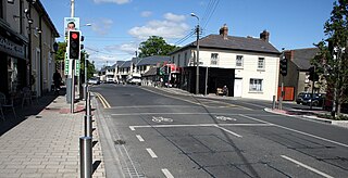
Stepaside is a village on the outskirts of Dublin located on its southside, located in Dún Laoghaire–Rathdown, Ireland. The area is situated 4 kilometres (2.5 mi) south of Dundrum.

Glencullen is a village and townland in the county of Dún Laoghaire–Rathdown in south County Dublin, Ireland. It is also the name of the valley above one end of which the village sits, and from which it takes its name, and is on the R116 road, on the slopes of Two Rock Mountain. The highest point of the area is at a height of about 300 metres (980 ft), making Glencullen one of the highest villages in Ireland.

Loughlinstown is a southern Dublin suburb, located in Dún Laoghaire–Rathdown, on the N11 national road.

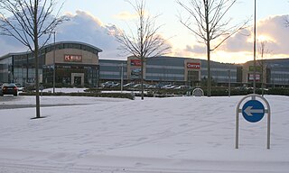
Cherrywood is a developing suburb of Dublin, Ireland, bordering Cabinteely, Loughlinstown and Rathmichael. It is located to the southeast of the city, in Dún Laoghaire–Rathdown. The development commenced on a greenfield site in 1998 and primarily comprises Cherrywood Business Park, and some residential development, with retail development and a hotel also planned.

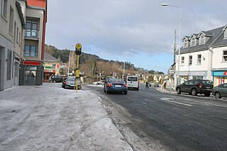
Kilternan, also known as Kiltiernan, is a village in Dún Laoghaire–Rathdown, in the foothills of the Wicklow Mountains south of Dublin, Ireland, near the border with County Wicklow.

The R117 road is a regional road in Ireland. The route (north-south) starts Harcourt Road at the end of the South Circular Road on the southside of Dublin city centre. It crosses the Grand Canal and goes through the suburbs of Ranelagh, Milltown, Windy Arbour, Dundrum, Sandyford, Stepaside and Kilternan before passing through the Scalp into County Wicklow.
Carrickmines is an outer suburb of Dublin in Dún Laoghaire–Rathdown, Ireland. The area, still semi-rural, was historically on the border of English control and featured a defensive construction, Carrickmines Castle, which became the subject of national controversy during the building of a late stage of Dublin's M50 orbital motorway.
Two Rock is a mountain in Dún Laoghaire–Rathdown, Ireland. It is 536 metres high and is the 382nd highest mountain in Ireland. It is the highest point of the group of hills in the Dublin Mountains which comprises Two Rock, Three Rock, Kilmashogue and Tibradden Mountains. The mountain takes its name from the two granite tors that lie to the south-east of the summit. From the summit, which is called Fairy Castle, there are views of much of the Dublin area from Tallaght to Howth to the north while Bray Head, Killiney Hill, the Great Sugar Loaf and the Wicklow Mountains are visible to the south. The summit area is mostly shallow bog while ferns and gorse cover the lower slopes. The mountain is also an important habitat for red grouse.

The Dublin Mountains Way is a waymarked long-distance trail in the Dublin Mountains, Counties South Dublin and Dún Laoghaire–Rathdown, Ireland. The route is approximately 42 kilometres long and runs from Shankill in the east to Tallaght in the west. It has been developed by the Dublin Mountains Partnership, an umbrella group of relevant state agencies and recreational users working to improve recreational facilities in the Dublin Mountains.

The R118 road is a regional road in south Dublin and Dún Laoghaire–Rathdown, Ireland. It links Kildare Street to Cherrywood.

Dublin Rathdown is a parliamentary constituency represented in Dáil Éireann, the lower house of the Irish parliament or Oireachtas, since the 2016 general election. The constituency elects three deputies on the system of proportional representation by means of the single transferable vote (PR-STV).

Brides Glen is a stop on the Luas light-rail tram system in Dún Laoghaire - Rathdown, south of Dublin, Ireland. It opened in 2010 as the terminus of an extension of the Green Line south from Sandyford.
The Glencullen River, often the Cookstown River below Enniskerry, is a watercourse of Dún Laoghaire–Rathdown and northern County Wicklow. About 11 kilometres (6.8 mi) long; it passes the nature reserve of Knocksink Wood and the village of Enniskerry, and joins the River Dargle near Bray. The river is in the jurisdictions of Dún Laoghaire–Rathdown and Wicklow County Councils, as well as within the purview of the Environmental Protection Agency.


