Ragueneau, Quebec

Last updated
Ragueneau
Parish municipality
Eglise de Ragueneau.jpg
Canada Cote-Nord Region Quebec.png
Red pog.svg
Ragueneau
Location in Côte-Nord region of Quebec.
Coordinates: 49°04′N68°32′W / 49.067°N 68.533°W / 49.067; -68.533 Coordinates: 49°04′N68°32′W / 49.067°N 68.533°W / 49.067; -68.533 [1]
CountryFlag of Canada.svg  Canada
Province Flag of Quebec.svg  Quebec
Region Côte-Nord
RCM Manicouagan
Settled 1920
Constituted March 7, 1951
Named for Paul Ragueneau [1]
Government [2]
  Mayor Claude Lavoie
   Federal riding Manicouagan
   Prov. riding René-Lévesque
Area [2] [3]
  Total 213.20 km2 (82.32 sq mi)
  Land 185.56 km2 (71.65 sq mi)
Population (2011) [3]
  Total 1,405
  Density 7.6/km2 (20/sq mi)
  Pop 2006-2011Decrease2.svg 7.6%
  Dwellings 661
Time zone EST (UTC−5)
  Summer (DST) EDT (UTC−4)
Postal code(s) G0H 1S0
Area code(s) 418 and 581
HighwaysQc138.svg Route 138
Website www.municipalite.
ragueneau.qc.ca

Ragueneau is a parish municipality in Quebec, Canada, on Outardes Bay on the north shore of the Saint Lawrence River.

Quebec Province of Canada

Quebec is one of the thirteen provinces and territories of Canada. It is bordered to the west by the province of Ontario and the bodies of water James Bay and Hudson Bay; to the north by Hudson Strait and Ungava Bay; to the east by the Gulf of Saint Lawrence and the province of Newfoundland and Labrador; and to the south by the province of New Brunswick and the U.S. states of Maine, New Hampshire, Vermont, and New York. It also shares maritime borders with Nunavut, Prince Edward Island, and Nova Scotia. Quebec is Canada's largest province by area and its second-largest administrative division; only the territory of Nunavut is larger. It is historically and politically considered to be part of Central Canada.

Saint Lawrence River Large river in eastern Canada and the United States, flowing into the Gulf of Saint Lawrence

The Saint Lawrence River is a large river in the middle latitudes of North America. The Saint Lawrence River flows in a roughly north-easterly direction, connecting the Great Lakes with the Atlantic Ocean and forming the primary drainage outflow of the Great Lakes Basin. It traverses the Canadian provinces of Quebec and Ontario, and is part of the international boundary between Ontario, Canada, and the U.S. state of New York. This river provides the basis for the commercial Saint Lawrence Seaway.

Contents

History

The first settlers arrived in 1920, mostly from Saint-Paul-du-Nord, Les Escoumins, and Sainte-Anne-de-Portneuf. That same year, Ragueneau Township was proclaimed and named after Jesuit Paul Ragueneau (1608-1680). In 1926, its post office opened. [1]

Longue-Rive, Quebec Municipality in Quebec, Canada

Longue-Rive is a municipality in the Côte-Nord region of the province of Quebec in Canada. The municipality includes the communities of Sault-au-Mouton, Baie-des-Bacon, Pointe-à-Boisvert, Rivière-Éperlan and Saint-Paul-du-Nord.

Les Escoumins, Quebec Municipality in Quebec, Canada

Les Escoumins is a municipality in La Haute-Côte-Nord Regional County Municipality in the Côte-Nord region of Quebec. It is located on the north shore of the Saint Lawrence River.

Portneuf-sur-Mer, Quebec Municipality in Quebec, Canada

Portneuf-sur-Mer is a municipality in the Côte-Nord region of the province of Quebec in Canada.

Three communities developed concurrently along the shores of the Saint Lawrence: Rivière-à-la-Truite in the north-east, Ruisseau-Vert in the centre, and Ragueneau in the south-west. The main administrative, commercial, cultural, and religious activities concentrated in Ruisseau-Vert, so that over time this community became known as Ragueneau itself. In 1951, the Parish Municipality of Ragueneau was incorporated. [1]

Demographics

Population trend: [4]

Private dwellings occupied by usual residents: 607 (total dwellings: 661)

Mother tongue:

Related Research Articles

Baie-Saint-Paul City in Quebec, Canada

Baie-Saint-Paul is a city in the Province of Quebec, Canada, on the northern shore of the Saint Lawrence River. Baie-Saint-Paul is the seat of Charlevoix Regional County Municipality. The city is situated at the mouth of the Gouffre River. It is known for its art galleries, shops and restaurants.

Berthierville City in Quebec, Canada

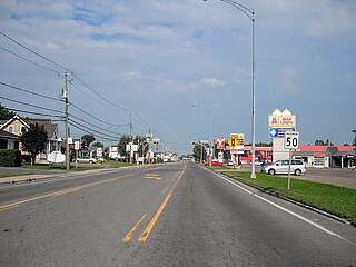
Berthierville is a town located between Montreal and Trois-Rivières on the north shore of the Saint Lawrence River in Quebec, Canada. Berthierville is the seat of D'Autray Regional County Municipality, and is served by Autoroute 40, and is the junction of Routes 138 and 158. It is surrounded by the parish municipality of Sainte-Geneviève-de-Berthier.

LIsle-aux-Coudres Municipality in Quebec, Canada

L'Isle-aux-Coudres is a municipality in Quebec, Canada, in the Charlevoix Regional County Municipality in the Charlevoix area of the Capitale-Nationale region. It is located on and contiguous with Coudres Island, located in the St. Lawrence River about 6 kilometres (3.7 mi) south from the mainland.

Château-Richer, Quebec City in Quebec, Canada

Château-Richer is a small town situated in the Capitale-Nationale region of Quebec, Canada. Located on the north shore of the Saint Lawrence River east of Quebec City, Château-Richer is the seat for the Côte-de-Beaupré Regional County Municipality.

Sainte-Marie-Salomé, Quebec municipality in Quebec, Canada

Sainte-Marie-Salomé is a municipality in the Lanaudière region of Quebec, Canada, part of the Montcalm Regional County Municipality.

Saint-Roch-de-lAchigan, Quebec Municipality in Quebec, Canada

Saint-Roch-de-l'Achigan is a Quebec municipality located in the Montcalm Regional County Municipality located in the Lanaudière region. It is on the banks of the Achigan River, a tributary of the L'Assomption River. According to the town's website, the population is approximately 4 500 and growing steadily as a result of the suburban sprawl in the northern crown of the Greater Montreal area.

Saint-Édouard-de-Fabre, Quebec Parish municipality in Quebec, Canada

Saint-Édouard-de-Fabre is a parish municipality in western Quebec, Canada, in the Témiscamingue Regional County Municipality.

Beaupré, Quebec City in Quebec, Canada

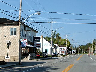
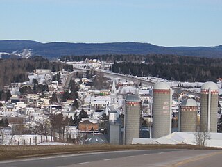
Beaupré is a ville in the Canadian province of Quebec, located in La Côte-de-Beaupré Regional County Municipality. The town is along the Saint Lawrence River and Route 138 at the mouth of the Sainte-Anne-du-Nord River.

Pointe-Calumet, Quebec Municipality in Quebec, Canada

Pointe-Calumet is a municipality in the Canadian province of Quebec. The municipality is located within the Deux-Montagnes Regional County Municipality in the Laurentides region. It is situated about 30 minutes northwest of Montreal. Its population as of the 2006 Canadian Census is just over 6 000.

Saint-Placide, Quebec Municipality in Quebec, Canada

Saint-Placide is a municipality in the Laurentides region of Quebec, Canada, part of the Deux-Montagnes Regional County Municipality, along the north shore of the Ottawa River.

Colombier, Quebec Municipality in Quebec, Canada

Colombier is a municipality in the Canadian province of Quebec, located in the Côte-Nord region and the regional county municipality of La Haute-Côte-Nord. It is located along Route 138, about 60 kilometres (37 mi) south-west of Baie-Comeau.

Saint-Paul, Quebec Municipality in Quebec, Canada

Saint-Paul is a municipality in the Lanaudière region of Quebec, Canada, part of the Joliette Regional County Municipality.

Saint-Gabriel-de-Brandon, Quebec Municipality in Quebec, Canada

Saint-Gabriel-de-Brandon is a municipality in the D'Autray Regional County Municipality in the Lanaudière region of Quebec, Canada.

Saint-Gabriel, Quebec City in Quebec, Canada

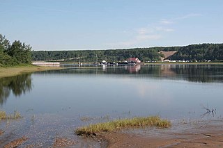
Saint-Gabriel is a town in the Lanaudière region of Quebec, Canada, part of the D'Autray Regional County Municipality. It is located on the shores of Lake Maskinongé, in the shadows of the Laurentian Mountains.

Saint-Siméon, Capitale-Nationale, Quebec Municipality in Quebec, Canada

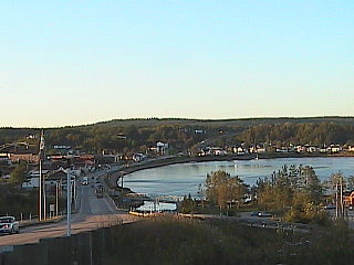
Saint-Siméon is a municipality in the Charlevoix-Est Regional County Municipality of Quebec, Canada. Founded in 1869, it was named after Saint Simeon of Jerusalem.

Petite-Rivière-Saint-François Municipality in Quebec, Canada

Petite-Rivière-Saint-François is a municipality in Quebec, Canada, along the Saint Lawrence River. It is considered the gateway to the Charlevoix region.

Les Éboulements Municipality in Quebec, Canada

Les Éboulements is a municipality in the Capitale-Nationale region of Quebec, Canada.

Saint-Tite-des-Caps Municipality in Quebec, Canada

Saint-Tite-des-Caps is a municipality in La Côte-de-Beaupré Regional County Municipality in Quebec, Canada. Located on Route 138 to Baie-Saint-Paul, this road climbs up sharply to about 700 meters (2,300 ft) to reach the town nestled in a valley. The Sainte-Anne-du-Nord River forms the municipal western boundary.

Saint-Joachim, Quebec Parish municipality in Quebec, Canada

Saint-Joachim is a parish municipality in Quebec, Canada. It is part of the La Côte-de-Beaupré Regional County Municipality in the Capitale-Nationale region. Located at the foot of Cape Tourmente, it is home to the Cap Tourmente National Wildlife Area.

References

  1. 1 2 3 4 "Ragueneau (Municipalité de paroisse)" (in French). Commission de toponymie du Québec. Retrieved 2010-06-30.
  2. 1 2 Ministère des Affaires municipales, des Régions et de l'Occupation du territoire - Répertoire des municipalités: Ragueneau
  3. 1 2 Statistics Canada 2011 Census - Ragueneau census profile
  4. Statistics Canada: 1996, 2001, 2006, 2011 census