Red Gulch/Alkali National Back Country Byway

Last updated

Red Gulch/Alkali National Back Country Byway

Route information
Maintained by Bureau of Land Management
Length 32 mi [1] (51 km)
Major junctions
South endWY-31.svg WYO 31 in Hyattville
North endUS 14.svg US 14 near Shell
Highway system

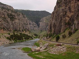
The Red Gulch/Alkali National Back Country Byway is a 32-mile-long (51 km) byway to the west of the Big Horn Mountains in Wyoming in the United States. It connects Wyoming Highway 31 (WYO 31) in Hyattville with U.S. Route 14 (US 14) near Shell.

National Scenic Byway Road recognized by the USDOT for one or more of six "intrinsic qualities": archeological, cultural, historic, natural, recreational, and scenic

A National Scenic Byway is a road recognized by the United States Department of Transportation for one or more of six "intrinsic qualities": archeological, cultural, historic, natural, recreational, and scenic. The program was established by Congress in 1991 to preserve and protect the nation's scenic but often less-traveled roads and promote tourism and economic development. The National Scenic Byways Program (NSBP) is administered by the Federal Highway Administration (FHWA).

Wyoming State of the United States of America

Wyoming is a state in the mountain region of the western United States. The state is the 10th largest by area, the least populous, and the second most sparsely populated state in the country. Wyoming is bordered on the north by Montana, on the east by South Dakota and Nebraska, on the south by Colorado, on the southwest by Utah, and on the west by Idaho and Montana. The state population was estimated at 577,737 in 2018, which is less than 31 of the most populous U.S. cities including Denver in neighboring Colorado. Cheyenne is the state capital and the most populous city, with an estimated population of 63,624 in 2017.

United States Federal republic in North America

The United States of America (USA), commonly known as the United States or America, is a country comprising 50 states, a federal district, five major self-governing territories, and various possessions. At 3.8 million square miles, the United States is the world's third or fourth largest country by total area and is slightly smaller than the entire continent of Europe's 3.9 million square miles. With a population of over 327 million people, the U.S. is the third most populous country. The capital is Washington, D.C., and the largest city by population is New York City. Forty-eight states and the capital's federal district are contiguous in North America between Canada and Mexico. The State of Alaska is in the northwest corner of North America, bordered by Canada to the east and across the Bering Strait from Russia to the west. The State of Hawaii is an archipelago in the mid-Pacific Ocean. The U.S. territories are scattered about the Pacific Ocean and the Caribbean Sea, stretching across nine official time zones. The extremely diverse geography, climate, and wildlife of the United States make it one of the world's 17 megadiverse countries.

Contents

Route description

The byway begins at an intersection with Wyoming Highway 31 (WYO 31) in Hyattville to U.S. Route 14 (US 14) south-southwest of Shell. Alkali Road and Red Gulch Road meet at 44°24′43″N107°33′25″W / 44.412°N 107.557°W / 44.412; -107.557 . The byway can be driven from May through to October; though light rain can make traveling conditions unsafe. Also, in dry conditions, there can be considerable dust. [1]

Intersection (road) A road junction where two or more roads either meet or cross at grade

An intersection is an at-grade junction where two or more roads meet or cross. Intersections may be classified by number of road segments, traffic controls, and/or lane design.

Wyoming Highway 31 (WYO 31) is a 22.09 miles (35.55 km) Wyoming state highway known locally as Cold Springs Road. Located in southern Big Horn County, the highway serves the town of Manderson and the community (CDP) of Hyattville.

Hyattville, Wyoming CDP in Wyoming, United States

Hyattville is a census-designated place (CDP) in Big Horn County, Wyoming, United States. The population was 75 at the 2010 census.

Attractions include the Red Gulch Dinosaur Tracksite and the Medicine Lodge State Archeological Site. [2]

Red Gulch Dinosaur Tracksite

Red Gulch Dinosaur Tracksite is an assemblage of fossil dinosaur footprints on public land near Shell, in Big Horn County, Wyoming.

Medicine Lodge State Archeological Site

Medicine Lodge State Archeological Site is a Wyoming state park that interprets the Medicine Lodge Creek Site, a prehistoric Native American archeological site near Hyattville, Wyoming. It is administered by the Wyoming Division of State Parks and Historic Sites. The site is at the base of a steep limestone outcropping near the point where the dry and running portions of Medicine Lodge Creek join. for a protected location with ready access to water. The site includes petroglyphs and pictographs on the rock face. Excavations starting in the 1970s have found twelve levels of habitation in 10.5 feet of stratum, ranging from historic times to 8300 years before the present. The site comprises a portion of the former Wickwire Ranch, which was purchased by the state in 1972 and became to Medicine Lodge Wildlife Habitat Management Area of 12,000 acres (4,900 ha). The archeological site was designated in 1973. The site is managed as a state park, with campgrounds and a visitor center. It was added to the National Register of Historic Places on July 5, 1973.

Major intersections

The entire route is in Big Horn County.

LocationmikmDestinationsNotes
Hyattville 00.0WY-31.svg WYO 31  Manderson, Hyattville Southern terminus
3251US 14.svg US 14  Greybull, Shell, Sheridan Northern terminus
1.000 mi = 1.609 km; 1.000 km = 0.621 mi

See also

Related Research Articles

Big Horn County, Wyoming County in the United States

Big Horn County is a county in the U.S. state of Wyoming. As of the 2010 United States Census, the population was 11,668. The county seat is Basin. Its north boundary abuts the south boundary of Montana.

U.S. Route 26 highway in the United States

U.S. Route 26 is an east–west United States highway. It started in Ogallala, Nebraska, and was subsequently extended to the West Coast in Oregon. When the U.S. highway system was first defined, it was limited to Nebraska and Wyoming; by the 1950s, it continued into Idaho and Oregon. The highway's eastern terminus is in Ogallala, Nebraska at an intersection with Interstate 80. Its western terminus is south of Seaside, Oregon at an intersection with U.S. Route 101. Prior to 2004, the route's last 20 miles (32 km) were co-signed with U.S. Route 101 from the highways' junction south of Seaside north to Astoria where its intersection with U.S. Route 30 was also U.S. 30's western terminus.

Wyoming Highway 24 (WYO 24) is a 46.72-mile (75.19 km) long Wyoming state highway known as the Bear Lodge Highway. The route passes through the northern portion of the Bear Lodge Mountains, part of the Black Hills National Forest. Highway 24 spans from U.S. Route 14 to the South Dakota state line, where it continues south as South Dakota Highway 34. The highway passes by Devils Tower National Monument.

Wind River Canyon

Wind River Canyon is a scenic Wyoming canyon on the Wind River. It is located between the towns of Shoshoni and Thermopolis and is a popular stop for visitors to Yellowstone National Park. It is accessible by U.S. Highway 20 and Wyoming Highway 789. It was designated as a Wyoming Scenic Byway in 2005.

Wyoming Highway 130 is known locally as the Snowy Range Road. It makes its way west from Laramie across the plains, and rises over the Medicine Bow Mountains. The road then turns north through the town of Saratoga, and ends at Interstate 80. The stretch of road over the mountains is a National Forest Byway. WYO 130 over Snowy Range Pass is closed during winter (November–May)

Wyoming Highway 789 (WYO 789) is a 407-mile-long (655 km) state highway in the U.S. state of Wyoming. WYO 789 travels south-to-north from the Colorado state line to the Montana state line. For most of its length, it is concurrent with other routes. It was the path of a formerly-proposed U.S. Route 789 that was cancelled.

Wyoming Highway 150 is a 23.05-mile (37.1 km) north-south Wyoming State Road that runs from the Wyoming–Utah state border to north to Evanston. It is the Wyoming portion of the Mirror Lake Scenic Byway.

In the U.S. state of Wyoming, U.S. Highway 14 runs east to west across the northern part of the state. The road connects South Dakota on the east with Yellowstone National Park on the west. It is mostly a two lane surface road except for several sections that it shares with Interstate 90.

Wyoming Highway 30 (WYO 30) is a 26.02-mile (41.88 km) long Wyoming state highway known locally as Otto Road located in southwestern Big Horn County. The highway serves the town of Burlington and unincorporated community of Otto.

Wyoming Highway 32 (WYO 32) is 31.48-mile (50.66 km) long Wyoming state highway known locally as Emblem Highway. The highway is located in northwestern Big Horn County and travels from the unincorporated community of Emblem north along the Park-Big Horn county line north to the town of Byron and east to Lovell.

Wyoming Highway 33 is a 1.39-mile (2.24 km) long Wyoming state highway located in Big Horn County southwest of Lovell.

Wyoming Highway 35 is a short north-south Wyoming state highway located in northwestern Big Horn County in Cowley.

Wyoming Highway 36 is a north-south Wyoming state highway located in south-central Big Horn County and acts as a bypass west of Basin.

Wyoming Highway 37 is a north-south Wyoming state highway located in northern Big Horn County and travels from U.S. Route 14A north into Bighorn Canyon National Recreation Area.

Wyoming Highway 114 is a 10.82-mile (17.4 km), roughly north-south, Wyoming State Road located in northeastern Park County and extreme northwestern Big Horn County. It provides travels between the communities of Garland and Deaver.

Wyoming Highway 332 is a 5.44-mile (8.8 km) north-south Wyoming State Road in central Sheridan County.

Wyoming Highway 295 is a 29.35-mile (47.2 km) north-south Wyoming state road located in northeastern Park County and western Big Horn County. All but 0.43 miles (0.7 km) of the route are located in Park County; the southernmost intersection on the highway is in Big Horn County instead. Although predominately a north-south highway, WYO 295 travels east-west for its first 8.7 miles.

References

  1. 1 2 Staff (January 13, 2011). "Red Gulch Byway". Bureau of Land Management: Worland Field Office. Retrieved December 23, 2013.
  2. America's Byways