Smart growth is an urban planning and transportation theory that concentrates growth in compact walkable urban centers to avoid sprawl. It also advocates compact, transit-oriented, walkable, bicycle-friendly land use, including neighborhood schools, complete streets, and mixed-use development with a range of housing choices. The term "smart growth" is particularly used in North America. In Europe and particularly the UK, the terms "compact city", "urban densification" or "urban intensification" have often been used to describe similar concepts, which have influenced government planning policies in the UK, the Netherlands and several other European countries.
Growth management, in the United States, is a set of techniques used by the government to ensure that as the population grows that there are services available to meet their demands. These are not necessarily only government services. Other demands such as the protection of natural spaces, sufficient and affordable housing, delivery of utilities, preservation of buildings and places of historical value, and sufficient places for the conduct of business are also considered.

A ski resort is a resort developed for skiing, snowboarding, and other winter sports. In Europe, most ski resorts are towns or villages in or adjacent to a ski area – a mountainous area with pistes and a ski lift system. In North America, it is more common for ski areas to exist well away from towns, so ski resorts usually are destination resorts, often purpose-built and self-contained, where skiing is the main activity.

In social science, the term built environment, or built world, refers to the human-made surroundings that provide the setting for human activity, ranging in scale from buildings to parks. It has been defined as "the human-made space in which people live, work, and recreate on a day-to-day basis." The "built environment encompasses places and spaces created or modified by people including buildings, parks, and transportation systems." In recent years, public health research has expanded the definition of "built environment" to include healthy food access, community gardens, mental health, "walkability", and "bikeability".
In social psychology, propinquity is one of the main factors leading to interpersonal attraction.
In the United States, a homeowner association is a private association often formed by a real estate developer for the purpose of marketing, managing, and selling homes and lots in a residential subdivision. Typically the developer will transfer control of the association to the homeowners after selling a predetermined number of lots. Generally any person who wants to buy a residence within the area of a homeowners association must become a member, and therefore must obey the governing documents including Articles of Incorporation, CC&Rs and By-Laws, which may limit the owner's choices. Most homeowner associations are incorporated, and are subject to state statutes that govern non-profit corporations and homeowner associations. State oversight of homeowner associations is minimal, and it varies from state to state. Some states, such as Florida and California, have a large body of HOA law. Other states, such as Massachusetts, have virtually no HOA law. Homeowners associations are commonly found in residential developments since the passage of the Davis–Stirling Common Interest Development Act in 1985.

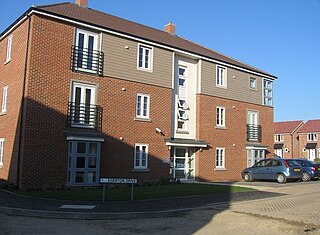
A housing estate is a group of homes and other buildings built together as a single development. The exact form may vary from country to country. Accordingly, a housing estate is usually built by a single contractor, with only a few styles of house or building design, so they tend to be uniform in appearance. In the British Isles, the term is quite broad, and can include anything from high rise government-subsidised housing, right through to more upmarket, developer-led suburban tract housing.

A residential area is a land used in which housing predominates, as opposed to industrial and commercial areas. Housing may vary significantly between, and through, residential areas. These include single-family housing, multi-family residential, or mobile homes. Zoning for residential use may permit some services or work opportunities or may totally exclude business and industry. It may permit high density land use or only permit low density uses. Residential zoning usually includes a smaller FAR than business, commercial or industrial/manufacturing zoning. The area may be large or small.

Urban sprawl or suburban sprawl mainly refers to the unrestricted growth in many urban areas of housing, commercial development, and roads over large expanses of land, with little concern for urban planning. In addition to describing a particular form of urbanization, the term also relates to the social and environmental consequences associated with this development. In Continental Europe the term "peri-urbanisation" is often used to denote similar dynamics and phenomena, although the term urban sprawl is currently being used by the European Environment Agency. There is widespread disagreement about what constitutes sprawl and how to quantify it. For example, some commentators measure sprawl only with the average number of residential units per acre in a given area. But others associate it with decentralization, discontinuity, segregation of uses, and so forth.
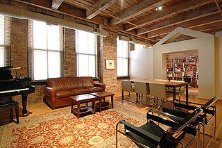
A loft can be an upper storey or attic in a building, directly under the roof or just a storage space under the roof usually accessed by a ladder. A loft apartment refers to large adaptable open space, often converted for residential use from some other use, often light industrial. Adding to the confusion, some converted lofts include upper open loft areas. Within certain upper loft areas exist even further lofts, which may contain loft areas of their own, and so forth.

Environmental assessment (EA) is the assessment of the environmental consequences of a plan, policy, program, or actual projects prior to the decision to move forward with the proposed action. In this context, the term "environmental impact assessment" (EIA) is usually used when applied to actual projects by individuals or companies and the term "strategic environmental assessment" (SEA) applies to policies, plans and programmes most often proposed by organs of state. Environmental assessments may be governed by rules of administrative procedure regarding public participation and documentation of decision making, and may be subject to judicial review.

An impact fee is a fee that is imposed by a local government within the United States on a new or proposed development project to pay for all or a portion of the costs of providing public services to the new development. Impact fees are considered to be a charge on new development to help fund and pay for the construction or needed expansion of offsite capital improvements. These fees are usually implemented to help reduce the economic burden on local jurisdictions that are trying to deal with population growth within the area.
A planned unit development (PUD) is a type of building development and also a regulatory process. As a building development, it is a designed grouping of both varied and compatible land uses, such as housing, recreation, commercial centers, and industrial parks, all within one contained development or subdivision.
Mixed-use development or often simply Live-work space is a type of urban development strategy for living spaces (housing) that blends residential, commercial, cultural, institutional, or entertainment uses, where those functions are physically and functionally integrated, and that provides pedestrian connections. Mixed-use development can take the form of a single building, a city block, or entire neighbourhoods. The term may also be used more specifically to refer to a mixed-use real estate development project—a building, complex of buildings, or district of a town or city that is developed for mixed-use by a private developer, (quasi-) governmental agency, or a combination thereof.

Automobile dependency is the concept that some city layouts cause automobiles to be favored over alternate forms of transportation such as bicycles, public transit, and walking.
Medium-density housing is residential developments that are at higher densities than standard low-density, suburban subdivisions, but not so high that they might be regarded as high density housing. In Australia the density of standard suburban residential areas has traditionally been between 8-15 dwellings per hectare. Medium density housing can range from about 25 to 80 dwellings per hectare, though most commonly the density is between 30 and 40 dwellings/hectare. Such developments may consist of detached, semi-attached and attached housing.

Zoning in the United States includes various land use laws falling under the police power rights of state governments and local governments to exercise authority over privately owned real property. The earliest zoning laws originated with the Los Angeles zoning ordinances of 1908 and the New York City Zoning resolution of 1916. Starting in the early 1920s, the United States Commerce Department drafted model zoning and planning ordinances in the 1920s to facilitate states in drafting enabling laws. Also in the early 1920s, a lawsuit challenged a local zoning ordinance in a suburb of Cleveland, which was eventually reviewed by the United States Supreme Court.
The compact city or city of short distances is an urban planning and urban design concept, which promotes relatively high residential density with mixed land uses. It is based on an efficient public transport system and has an urban layout which – according to its advocates – encourages walking and cycling, low energy consumption and reduced pollution. A large resident population provides opportunities for social interaction as well as a feeling of safety in numbers and 'eyes on the street'. It is also arguably a more sustainable urban settlement type than urban sprawl because it is less dependent on the car, requiring less infrastructure provision.

Euralille is an urban quarter in the centre of Lille, France. Conceived as a major European business district in the 1980s, it is strategically located at the intersection of the high-speed railway lines linking Paris, Brussels, and London, and incorporates the Gare de Lille Europe and Gare de Lille Flandres railway stations. The master plan was commissioned in 1988 to the Office of Metropolitan Architecture (OMA) led by Rem Koolhaas.


