This page is based on this
Wikipedia article Text is available under the
CC BY-SA 4.0 license; additional terms may apply.
Images, videos and audio are available under their respective licenses.

The provinces of the Colony of New Zealand existed as a form of sub-national government. Established in 1841, each province had its own legislature and was built around the six original planned settlements or "colonies". By 1873 the number of provinces had increased to nine, but they had become less isolated from each other and demands for centralised government arose. In 1875 the national parliament decided to abolish the provincial governments, and they came to an end in 1876. They were superseded by counties, which were later replaced by territorial authorities.

Fiordland is a geographic region of New Zealand in the south-western corner of the South Island, comprising the western-most third of Southland. Most of Fiordland is dominated by the steep sides of the snow-capped Southern Alps, deep lakes, and its steep, glacier-carved and now ocean-flooded western valleys. The name "Fiordland" comes from a variant spelling of the Scandinavian word for this type of steep valley, "fjord". The area of Fiordland is dominated by, and very roughly coterminous with, Fiordland National Park, New Zealand's largest National Park.

Southland District is a territorial authority in the South Island of New Zealand.

The Catlins comprises an area in the southeastern corner of the South Island of New Zealand. The area lies between Balclutha and Invercargill, straddling the boundary between the Otago and Southland regions. It includes the South Island's southernmost point, Slope Point.

Westland District is a territorial authority on the West Coast of New Zealand's South Island. It is administered by the Westland District Council. The district's population is 8,890.
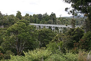
Percy Burn Viaduct is located in the far south of the South Island of New Zealand. It is reputedly the largest surviving wooden viaduct in the world. A former logging tramway, it is now a closed footbridge and the most popular feature of the Tuatapere Hump Ridge Track.
Woodlands is a locality in the Southland region of New Zealand's South Island on the banks of the Waihopai River. It is northeast of Invercargill between Dacre and Longbush. Other nearby settlements are Rakahouka to the northwest and Rimu and Waituna to the south.

Kennington is a town located in the Southland region of New Zealand's South Island. It is situated on the Waihopai River on the eastern outskirts of the city of Invercargill. Other nearby settlements include Longbush, Myross Bush, Rimu, and Woodlands.
Te Tipua is a locality in the eastern Southland region of New Zealand's South Island. It is west of the nearest town, Mataura, and northeast of Southland's major centre, Invercargill. New Zealand State Highway 96 passes through Te Tipua as it runs between Waitane and its junction with State Highway 1 on the southern side of Mataura.
Happy Valley is the name of four locations in New Zealand:
Oteramika is a locality in the Southland Region of New Zealand's South Island. It is in a rural setting near Waituna and Woodlands to the north, Rimu to the west, and to the south on the Southern Scenic Route are Mokotua, Kapuka, and Ashers. The major centre of Southland, Invercargill, is over 15 km west.
Mokotua is a locality in the Southland Region of New Zealand's South Island. It is situated in a rural area east of Invercargill, between Timpanys and Kapuka on the Southern Scenic Route. To the south are Toetoes Bay and Waituna Lagoon; Rimu is to the north.
Timpanys is a locality in the Southland Region of New Zealand's South Island. It is situated in a rural area east of Invercargill and is on the Southern Scenic Route between Waimatua and Mokotua. Rimu is to the north and Waituna Lagoon and Tiwai Point are to the south.
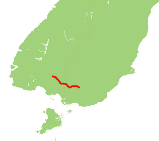
State Highway 96 is a New Zealand state highway connecting the Southland communities of Mataura, Winton, and Ohai. Starting at State Highway 1 the highway is 92 kilometres in length and runs in a general east-west direction. In Winton State Highway 96 runs concurrently with State Highway 6 for 1.6 kilometres.
The Otago rugby league team are New Zealand rugby league team that represents the Otago Rugby League. They are known as the Whalers. In the past they have been nicknamed the Storm, the Raiders and the 45er's.
The Southland rugby league team are New Zealand rugby league team that represents the Southland Rugby League. In the past they have been nicknamed the Rams.
State Highway 90 is a New Zealand State Highway connecting the town of Gore on State Highway 1 to the locality of Raes Junction on State Highway 8 via Tapanui, servicing the agricultural areas of eastern Southland and West Otago. It is mostly hilly and is just under 60 kilometres long.

Southland is New Zealand's southernmost region. It consists mainly of the southwestern portion of the South Island and Stewart Island / Rakiura. It includes Southland District, Gore District and the city of Invercargill. The region covers over 3.1 million hectares and spans over 3,400 km of coast.
