
The Lake McDonald Lodge Historic District is a historic district in Glacier National Park in the U.S. state of Montana. It comprises the Lake McDonald Lodge and surrounding structures on the shores of Lake McDonald. It is centered on the main lodge, which was designated a National Historic Landmark in 1987, as well as surrounding guest cabins, dormitory buildings, employee residences, utility buildings, and retail structures. The district includes several privately owned inholding structures that are contributing structures, as well as a number of non-contributing buildings.
U.S. Route 66, the historic east–west US highway between Chicago, Illinois and Santa Monica, California, passed through one brief segment in the southeastern corner of Kansas. It entered the state south of Baxter Springs and continued north until it crossed the Brush Creek, from where it turned east and left the state in Galena. After the decertification of the highway in 1985, this road segment was numbered as US-69 (alternate) from Quapaw, Oklahoma north to Riverton, Kansas and as K-66 from Riverton east to Route 66 in Missouri.
U.S. Route 66 is a former east–west United States Numbered Highway, running from Santa Monica, California to Chicago, Illinois. In Missouri, the highway ran from downtown St. Louis at the Mississippi River to the Kansas state line west of Joplin. The highway was originally Route 14 from St. Louis to Joplin and Route 1F from Joplin to Kansas. It underwent two major realignments and several lesser realignments in the cities of St. Louis, Springfield, and Joplin. Current highways covering several miles of the former highway include Route 100, Route 366, Route 266, Route 96, and Route 66. Interstate 44 (I-44) approximates much of US 66 between St. Louis and Springfield.

Watoga State Park is the largest of West Virginia's state parks, covering slightly over 10,100 acres (41 km2). It is located near Seebert in Pocahontas County, West Virginia.

The Rising Sun Auto Camp, also known as the Roes Creek Auto Camp, East Glacier Auto Camp or simply Rising Sun preserves a portion of the built-up area of Glacier National Park that documents the second phase of tourist development in the park. Rising Sun is located along the Going-to-the-Sun Road, approximately 7 miles (11 km) from the east entrance to Glacier National Park, Montana, United States. Rising Sun is a wayside area that has a National Park Service campground, a camp store and gift shop, picnic area, restaurant, as well as a motel and guest cabins which are managed by the park's concessionaire, Xanterra Parks & Resorts. In the immediate area, there is also a boat dock as well as sightseeing boats which allow visitors to tour Saint Mary Lake, the second largest lake in the park. "The most popular spot for [Glacier] tourists is Rising Sun, an overlook of Goose Island in St. Mary Lake and one of the most photographed spots in the park."

Backbone State Park is Iowa's oldest state park, dedicated in 1919. Located in the valley of the Maquoketa River, it is approximately three miles (5 km) south of Strawberry Point in Delaware County. It is named for a narrow and steep ridge of bedrock carved by a loop of the Maquoketa River originally known as the Devil's Backbone. The initial 1,200 acres (490 ha) were donated by E.M. Carr of Lamont, Iowa. Backbone Lake Dam, a relatively low dam built by the Civilian Conservation Corps (CCC) in the 1930s, created Backbone Lake. The CCC constructed a majority of trails and buildings which make up the park.

The Old Faithful Historic District in Yellowstone National Park comprises the built-up portion of the Upper Geyser Basin surrounding the Old Faithful Inn and Old Faithful Geyser. It includes the Old Faithful Inn, designed by Robert Reamer and itself a National Historic Landmark, the upper and lower Hamilton's Stores, the Old Faithful Lodge, designed by Gilbert Stanley Underwood, the Old Faithful Snow Lodge, and a variety of supporting buildings. The Old Faithful Historic District itself lies on the 140-mile Grand Loop Road Historic District.

The Roosevelt Lodge Historic District comprises the area around the Roosevelt Lodge in the northern part of Yellowstone National Park, near Tower Junction. The district includes 143 buildings ranging in size from cabins to the Lodge, built beginning in 1919. The Lodge was first conceived as a field laboratory for students and educators conducting research in the park. It later became a camp for tourists, specifically designed to accommodate automobile-borne tourists. The Lodge is a simplified version of the National Park Service Rustic style.

The Faraway Ranch Historic District is part of the Chiricahua National Monument in southern Arizona, and preserves an area associated with the final conflicts with the local Apache, one of the last frontier settlements, and in particular, its association with the people who promoted the establishment of the Chiricahua National Monument. Faraway Ranch is located in Bonita Canyon, which lies at an approximate altitude of 5160 feet and opens in a southwesterly direction into the Sulphur Springs Valley.

The Buckey O'Neill Cabin was built in 1890 by William "Buckey" O'Neill in what would become Grand Canyon National Park. O'Neill was, among many other things, a member of Theodore Roosevelt's Rough Riders, who had previously been an author, sheriff, and a judge in his native Arizona. He was killed in action in Cuba in 1898, but was instrumental in establishing what would eventually become the Grand Canyon Railroad.

The Bryce Canyon Lodge Historic District surrounds and includes the Bryce Canyon Lodge in Bryce Canyon National Park, as well as the survivors of a large complex of buildings that comprised the core of the park's visitor services area in the 1930s.

Thompson's Bromine and Arsenic Springs, also known as Healing Springs, is a historic mineral spring resort and national historic district located near Crumpler, Ashe County, North Carolina. The district encompasses 10 contributing buildings and 1 contributing site. They include the octagonal plan spring house and frame double cabin, frame bath house, a long frame cabin structure, 5 cabins, and a double cabin. The Bromine-Arsenic Springs Hotel was constructed in 1887 and burned to the ground in 1962; its former location is considered an archaeological site.

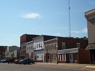
The West Liberty Commercial Historic District in West Liberty, Iowa, United States, is a historic district that was listed on the National Register of Historic Places in 2002. At that time, it included 41 contributing buildings, six other contributing structures, and eight non-contributing buildings.

Cabins Historic District is a national historic district located near Novinger, Adair County, Missouri. The district encompasses nine contributing buildings, three contributing sites, four contributing structures, and one contributing object in a relatively isolated area near Novinger. It developed between about 1829 and 1865 and was one of the earliest settlements in the interior of northeast Missouri. It includes five antebellum structures surrounded by forests and farm land. They are the John B. Cain House, the Asa King Collett House, the Ira R. Collett House and its poultry house and summer kitchen. Other notable contributing resources include the Conner Tannery site, the Collett Spring, the site of Fort Clark, the site of Camp Collett, the Collett Cemetery, and Native American burial mounds.

Big Hill Farmstead Historic District is a historic home and farm and national historic district located at Jackson, Cape Girardeau County, Missouri. The farmhouse was built about 1855, and is a two-story, five bay, brick I-house with Greek Revival and Italianate style design elements. It has a hipped roof and features a gallery porch. Other contributing elements are the a timber frame barn, a cabin/workshop, a wagon shed, and the surrounding farmland.

Big Spring Historic District is a national historic district located at Van Buren, Carter County, Missouri. It encompasses 26 contributing buildings, 1 contributing site, and contributing structure in the Ozark National Scenic Riverways. It includes the Big Spring, rental cabins, service building, storage shed, garage, a museum, dining lodge, restroom, shelter house, ranger station, pump house, footbridge, and two picnic shelters. The structures represent the best features of park construction by the Civilian Conservation Corps in Missouri.
Alfred W. Morrison House, also known as Lilac Hill, is a historic home located near Fayette, Howard County, Missouri. It was built about 1830, and is a 2 1/2-story, Federal style brick dwelling with flanking 1 1/2-story wings. Also on the property is a contributing slave cabin of wood frame construction.
Isiah Mansur Farmstead Historic District, also known as Rock Hall, is a historic home and farm and national historic district located near Richmond, Ray County, Missouri. The district encompasses eight contributing buildings, one contributing site, and three contributing structures on a farm developed between the mid-19th and mid-20th centuries. The contributing resources include the main farmhouse, a buggy house, a large barn, an engine house (c.1900), a small barn, a brooder house, a hen house, a smokehouse, a house well, a field well, and a wellhouse. The main farmhouse is a two-story, five bay, frame I-house.
Button Rock School, also known as the Buttin School, and District #85 School, is a historic one-room school building and national historic district located in the Ozark National Scenic Riverways near Eminence, Shannon County, Missouri. The school was built in 1913, and is a one-story, rectangular frame building on a pier foundation. It has a gable roof and is sheathed in novelty siding painted white. Also on the property is a contributing frame privy.
The Wilton Commercial Historic District is a nationally recognized historic district located in Wilton, Iowa, United States. It was listed on the National Register of Historic Places in 2016. At the time of its nomination it consisted of 47 resources, which included 32 contributing buildings, one contributing structure and 14 non-contributing buildings. Wilton got its start when the Mississippi and Missouri Railroad, later the Chicago, Rock Island and Pacific, was surveyed through this area in 1853. It was named for Wilton, Maine, the hometown of one of the founders.


