Related Research Articles

Newspaper Rock State Historic Monument is a Utah state monument featuring a rock panel carved with one of the largest known collections of petroglyphs. It is located in San Juan County, along Utah State Route 211, 28 miles (45 km) northwest of Monticello and 53 miles (85 km) south of Moab.

A petroglyph is an image created by removing part of a rock surface by incising, picking, carving, or abrading, as a form of rock art. Outside North America, scholars often use terms such as "carving", "engraving", or other descriptions of the technique to refer to such images. Petroglyphs, estimated to be 20,000 years old are classified as protected monuments and have been added to the tentative list of UNESCO's World Heritage Sites. Petroglyphs are found worldwide, and are often associated with prehistoric peoples. The word comes from the Greek prefix petro-, from πέτρα petra meaning "stone", and γλύφω glýphō meaning "carve", and was originally coined in French as pétroglyphe.

In archaeology, rock arts are human-made markings placed on natural surfaces, typically vertical stone surfaces. A high proportion of surviving historic and prehistoric rock art is found in caves or partly enclosed rock shelters; this type also may be called cave art or parietal art. A global phenomenon, rock art is found in many culturally diverse regions of the world. It has been produced in many contexts throughout human history. In terms of technique, the four main groups are:

El Morro National Monument is a U.S. national monument in Cibola County, New Mexico, United States. Located on an ancient east–west trail in the western part of the state, the monument preserves the remains of a large prehistoric pueblo atop a great sandstone promontory with a pool of water at its base, which subsequently became a landmark where over the centuries explorers and travelers have left personal inscriptions that survive today.

Washington State Park is a public recreation area covering 2,147 acres (869 ha) in Washington County in the central eastern part of the state of Missouri. It is located on Highway 21 about 14 miles (23 km) northeast of Potosi or 7 miles (11 km) southwest of De Soto on the eastern edge of the Ozarks. The state park is noted for its Native American rock carvings and for its finely crafted stonework from the 1930s.

Coso Rock Art District is a rock art site containing over 100,000 Petroglyphs by Paleo-Indians and/or Native Americans. The district is located near the towns of China Lake and Ridgecrest, California. Big and Little Petroglyph Canyons were declared a National Historic Landmark in 1964. In 2001, they were incorporated into this larger National Historic Landmark District. There are several other distinct canyons in the Coso Rock Art District besides the Big and Little Petroglyph Canyons. Also known as Little Petroglyph Canyon and Sand Tanks, Renegade Canyon is but one of several major canyons in the Coso Range, each hosting thousands of petroglyphs. The majority of the Coso Range images fall into one of six categories: bighorn sheep, entopic images, anthropomorphic or human-like figures, other animals, weapons & tools, and "medicine bag" images. Scholars have proposed a few potential interpretations of this rock art. The most prevalent of these interpretations is that they could have been used for rituals associated with hunting.

The Crane Petroglyph Heritage Site is the largest known petroglyph site in the Verde Valley of central Arizona, and one of the best-preserved. The rock art site consists of 1,032 petroglyphs in 13 panels. Acquired by the Coconino National Forest in 1994, the site is protected and kept open to the public by the US Forest Service. Volunteers from the Verde Valley Archaeological Society and the Friends of the Forest provide interpretive tours and on-site management.
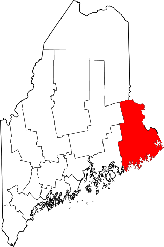
This is a list of the National Register of Historic Places listings in Washington County, Maine.

The Picture Rock Pass Petroglyphs Site is in northern Lake County, Oregon, United States. The site is located near the summit of Picture Rock Pass on land administered by the Bureau of Land Management. The designs were scraped into a basalt boulder by ancient Native Americans, probably between 7,500 and 12,000 years ago. No one knows the meaning of the petroglyph designs. Because of its unique archaeological and cultural significance, the Picture Rock Pass Petroglyph Site was listed on the National Register of Historic Places in 1975.

The Bellows Falls Petroglyph Site is an archaeological site containing panels of precontact Native American petroglyphs in Bellows Falls, Vermont. Located near the Vilas Bridge on bedrock west of and above the Connecticut River, adjacent to Great Falls, they depict a rarely-seen assemblage of anthropomorphic figures that is believed to be unique in New England, and uncommon even in surrounding geographic areas. The site was listed on the National Register of Historic Places in 1990.
The Marshall Site is an archaeological site in the Marshall State Fish and Wildlife Area in Marshall County, Illinois, across the Illinois River from Chillicothe. The site consists of a boulder carved with five petroglyphs. The petroglyphs, which archaeologists believe were created by Native Americans between 1673 and 1835, depict three anthropomorphs, an L-shaped figure, and a possible avimorph. The site was added to the National Register of Historic Places on August 25, 2014.
The Hodgdon Site, designated the Maine Archeological Survey Site 69.4, is a prehistoric rock art site near Embden, Maine. The site is located on a ledge overlooking the Kennebec River, in territory that was under the control of the Norridgewock tribe around the time of European contact, and is several miles downriver from the historic Norridgewock village. The markings are estimated to date to the Late Ceramic Period and include anthropomorphic representations of human figures, as well as an unusual representation of a post-and-beam structure topped by parallel semicircular arcs. This latter figure is thought to represent the house of Father Sébastien Rale, a French Jesuit priest who built a house at Norridgewock in 1722.
The Unai Dangkulo Petroglyph Site is one of a small number of documented rock art sites in the Mariana Islands. Located on the northeastern shore of the island of Tinian in the Northern Marianas, it is the only such site composed exclusively of pictographs. It is also uncommon in that it is not found in a cave-like setting, which is where most of the other rock art sites in the region are found. The site is on a limestone outcrop that is sometimes covered by sand or cleared of sand by typhoons, and was discovered in 1998 after it was exposed by Typhoon Keith. It consists of about 50 figures, many of them anthropomorphic.
Birch Point, also known as Clark's Point, is a peninsula in Machiasport, Maine. It separates Sanborn Cove to the north from Larrabee Cove to the south on the west side of Machias Bay, a short way south of the mouth of the Machias River. The point is of prehistoric and historic importance to the local Passamaquoddy people, as it is the site of large panels of rock art which have been listed on the National Register of Historic Places.
The Devils Head Site, designated Site 97.10 by the Maine Archaeological Survey, is a prehistoric and historic archaeological site in Calais, Maine. Located on the banks of the St. Croix River, it is a shell midden site with evidence of multiple periods of human habitation, from the Middle Ceramic Period to the Late Contact Period and beyond. With its location near Saint Croix Island, the site of an early French settlement in 1604, the site's finds may provide insight into early French-Native relations in the area. The site was listed on the National Register of Historic Places in 2006.

The East Lake Abert Archeological District is an area in Lake County, Oregon, United States, that features numerous prehistoric camp sites and petroglyphs. It is located along the eastern shore of Lake Abert on land administered by the Bureau of Land Management and the Oregon Department of Transportation. The site includes stone-walled house pits and prehistoric rock art made by ancient Native Americans who occupied the site for approximately 11,000 years. Because of its unique archaeological and cultural significance, the East Lake Abert Archaeological District was listed on the National Register of Historic Places in 1978.
The La Barge Bluffs Petroglyphs is a historic site which was listed on the National Register of Historic Places in 2014.

Trialeti petroglyphs is prehistoric rock art in the Trialeti area, in the Tsalka Municipality, engraved over a number of periods from the Mesolithic to the Middle Bronze Age. The depictions include geometric, zoomorphic and anthropomorphic images. It is recognized as a monument of the Cultural Heritage of Georgia and is part of the Prehistoric Rock Art Trails, a cultural route designated by the Council of Europe.
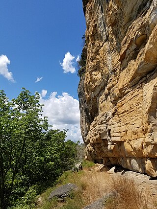
Painted Bluff is a cliff overlooking the Tennessee River in Marshall County, Alabama that features over 130 individual prehistoric Native American pictographs and petroglyphs. Painted Bluff is located about 4 miles (6.4 km) downstream from the Guntersville Dam and is only accessible by boat. The bluff is divided into three levels: the low ledge along the river, a middle ledge above it, and a high ledge near the top of the cliff face. A small cave is located along the low ledge.
References
- Lenik, Edward (2002). Picture Rocks: American Indian Rock Art in the Northeast Woodlands. University Press of New England. ISBN 9781584651970.
- 1 2 "National Register Information System". National Register of Historic Places . National Park Service. July 9, 2010.
- ↑ Lenik, p. 41
- ↑ Lenik, p. 45
- ↑ Lenik, p. 47
- ↑ Lenik, pp. 58-64
- ↑ Hedden, Mark (2002). "Contact Period Petroglyphs in Machias Bay, Maine". Archaeology of Eastern North America. 30: 1–20. JSTOR 40914453.