
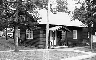
The Jackson Lake Ranger Station is the last Depression-era U.S. Forest Service ranger station in its original location in Grand Teton National Park. When first established, the park comprised only the mountainous terrain above Jackson Hole, while the remainder of what would eventually become the park was administered by the Forest Service as part of Teton National Forest. The Jackson Lake Station was built in 1933 as close as possible to Park Service property as possible as a kind of resistance to the park's expansion. The station was one of five Forest Service stations in the area, and was taken over by the National Park Service when Jackson Hole National Monument was established in 1943, later becoming an enlarged Grand Teton National Park. It is the only such station not to have been moved or altered by the Park Service.

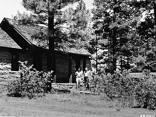
The White Grass Ranger Station includes several structures in the backcountry of Grand Teton National Park that were established to support horse patrols by park rangers. Built in 1930, White Grass is the only surviving horse patrol station in the park. The station, which includes a cabin, several sheds and a corral, was built to a standardized National Park Service plan, in the National Park Service rustic style.

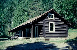
The Jenny Lake Ranger Station Historic District comprises an area that was the main point of visitor contact in Grand Teton National Park from the 1930s to 1960. Located near Jenny Lake, the buildings are a mixture of purpose-built structures and existing buildings that were adapted for use by the National Park Service. The ranger station was built as a cabin by Lee Mangus north of Moose, Wyoming about 1925 and was moved and rebuilt around 1930 for Park Service use. A store was built by a concessioner, and comfort stations were built to Park Service standard plans. All buildings were planned to the prevailing National Park Service Rustic style, although the ranger station and the photo shop were built from parts of buildings located elsewhere in the park.
The East Glacier Ranger Station in Glacier National Park is characteristic of park buildings constructed in the 1920s and 1930s. It was designed by Daniel Ray Hull of the National Park Service Office of Plans, as a frame building compatible in style with the prevailing National Park Service Rustic style. It is the center of a group of related buildings, including several residential structures.

The Belly River Ranger Station Historic District in Glacier National Park includes several historic structures, including the original ranger station, now used as a barn. The rustic log structures were built beginning in 1912. Other buildings include a woodshed, built in 1927 to standard National Park Service plans and a cabin used as a fire cache.

The Isabella Ranger Station is a complex of 21 buildings in Stony River Township, Minnesota, United States, near the town of Isabella. It is located on Minnesota State Highway 1 about one mile east of Isabella. The complex is listed on the National Register of Historic Places for its association with New Deal federal relief construction.

The Crown King Ranger Station is a ranger station near the top of Crown King Mountain in the area of Crown King, Arizona. It was built in 1934 by the Civilian Conservation Corps. Known also as Crown King Work Station or Crown King Administrative Site, it was listed on the National Register of Historic Places in 1993 for its architecture. It was designed by the USDA Forest Service in Bungalow/Craftsman style. It served as institutional housing and government office space. The NRHP listing included five contributing buildings on a 1.5-acre (6,100 m2) area. The complex includes a residence, an office, a barn/garage/shop, a hay barn, and a well building.
The Moqui Ranger Station in Kaibab National Forest near Tusayan, Arizona, also known as Tusayan Ranger Station, was built in 1939 by the Civilian Conservation Corps (CCC). It was listed on the National Register of Historic Places in 1993 for its architecture, which includes Bungalow architecture, Rustic architecture, vernacular and other styling. It was designed by the USDA Forest Service. The listing includes institutional housing and government office space in six contributing buildings and one other contributing structure over 2 acres (0.81 ha) In addition to CCC labor, workers from the Works Progress Administration (WPA) may have also been involved in the ranger station construction. The station replaced the old Hull Tank Ranger Station.
Sycamore Ranger Station, also known as Sycamore Work Center and as Sycamore Administrative Site, in Prescott National Forest near Camp Verde, Arizona was built in 1940 by the Civilian Conservation Corps. It was listed on the National Register of Historic Places in 1993 for its architecture, which includes vernacular, national(?), and other styles. It was designed by architects of the United States Forest Service. It served historically as institutional housing and as government office space. The NRHP listing included two contributing buildings on 2.5 acres (1.0 ha).

The Atlanta Ranger Station, also known as Atlanta Guard Station, is a 24 acres (9.7 ha) historic district in Boise National Forest in Atlanta, Idaho that was listed on the National Register of Historic Places in 2003. It includes 10 contributing buildings dating as far back as 1933. The complex was built by the Civilian Conservation Corps and designed by the USDA Forest Service, and includes Forest Service R-4 Standard and other architecture. The listing included ten contributing buildings.
Architects of the National Park Service are the architects and landscape architects who were employed by the National Park Service (NPS) starting in 1918 to design buildings, structures, roads, trails and other features in the United States National Parks. Many of their works are listed on the National Register of Historic Places, and a number have also been designated as National Historic Landmarks.

Cassville Ranger Station Historic District is a national historic district located near Cassville, Barry County, Missouri. The district encompasses five frame and limestone buildings constructed by Civilian Conservation Corps in 1936. They are the 1 1/2-story, Colonial Revival style Ranger's Office; 1 1/2-story, Colonial Revival style Ranger's Dwelling; garage; warehouse; oil house; and two stone carvings. It continues to be used as a Ranger Station for the Mark Twain National Forest.

Big Spring Historic District is a national historic district located at Van Buren, Carter County, Missouri. It encompasses 26 contributing buildings, 1 contributing site, and contributing structure in the Ozark National Scenic Riverways. It includes the Big Spring, rental cabins, service building, storage shed, garage, a museum, dining lodge, restroom, shelter house, ranger station, pump house, footbridge, and two picnic shelters. The structures represent the best features of park construction by the Civilian Conservation Corps in Missouri.

Ava Ranger Station Historic District is a national historic district located near Ava, Douglas County, Missouri. The district encompasses five frame and limestone buildings constructed by Civilian Conservation Corps in 1936. They are the 1 1/2-story, Colonial Revival style Ranger's Office; 1 1/2-story, Colonial Revival style Ranger's Dwelling; garage; warehouse and an oil house. It continues to be used as a Ranger Station for the Mark Twain National Forest.

Henry H. Hohenschild, also known as H.H. Hohenschild, was an architect based in Rolla, Missouri, USA. He born at St. Louis, and educated in the city's public schools. He moved to Rolla in 1881, where he established an architectural practice designing public and residential buildings. He was elected to the Missouri Senate in 1896. In 1899 was appointed State Architect by Governor Lon V. Stephens which involved the architect in designing several state buildings including some at the state penitentiary. In addition to 10 county courthouses, he designed several buildings for the School of Mines, the State Mental Institution in Farmington (1901), the Tuberculosis Sanitarium in Mount Vernon, Missouri (1905), and the temporary state capitol building in Jefferson City in 1912. He died on February 3, 1928 in St. Louis from a heart condition.
Winona Ranger Station Historic District is a historic ranger station and national historic district located in Mark Twain National Forest near Winona, Shannon County, Missouri. The district encompasses four contributing buildings, associated with a ranger station constructed by the Civilian Conservation Corps (CCC) under the supervision of a Works Progress Administration (WPA) project. It developed between 1938 and 1938 and includes 1 1/2-story, Colonial Revival style ranger's dwelling, garage, warehouse, and oil house.
Houston Ranger Station Historic District is a national historic district located in Mark Twain National Forest near Houston, Texas County, Missouri. The district encompasses five frame and limestone buildings constructed by the Lynchburg Camp of the Civilian Conservation Corps (CCC) during 1936 and 1937. They are the 1 1/2-story Colonial Revival style ranger's office, 1 1/2-story Colonial Revival style dwelling, garage, warehouse and oil house.
The Lochsa Historical Ranger Station, also known as Lochsa Ranger Station, near Kooskia, Idaho in Idaho County, Idaho, was built during 1927 to 1933. It served as administrative headquarters for the Lochsa Ranger District from 1922 to 1957. It was located within the Selway National Forest which was later merged into the Clearwater National Forest and the Nezperce National Forest. It was listed on the National Register of Historic Places in 1978.


