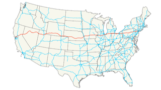
Interstate 80 (I-80) is an east–west transcontinental freeway in the United States that runs from downtown San Francisco, California, to Teaneck, New Jersey, in the New York City Metropolitan Area. The highway was designated in 1956 as one of the original routes of the Interstate Highway System. Its final segment was opened to traffic in 1986. It is the second-longest Interstate Highway in the United States, following I-90. The Interstate runs through many major cities including Oakland, Sacramento, Reno, Salt Lake City, Omaha, Des Moines, and Toledo, and passes within 10 miles (16 km) of Chicago, Cleveland, and New York City.

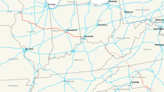
Interstate 64 (I-64) is an Interstate Highway in the Eastern United States. Its western terminus is at I-70, U.S. Route 40 (US 40), and US 61 in Wentzville, Missouri. Its eastern terminus is at an interchange with I-264 and I-664 at Bowers Hill in Chesapeake, Virginia. I-64 connects the major metropolitan areas of St. Louis, Missouri; Louisville, Kentucky; Lexington, Kentucky; Charleston, West Virginia; Richmond, Virginia; Norfolk, Virginia; and Virginia Beach, Virginia.
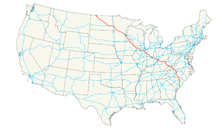
Interstate 71 (I-71) is a north-south Interstate Highway in the Great Lakes/Midwestern and Southeastern region of the United States. Its southern terminus is at an interchange with Interstate 64 and Interstate 65 in Louisville, Kentucky. Its northern terminus is at an interchange with Interstate 90 in Cleveland, Ohio. I-71 runs concurrently with Interstate 75 from a point about twenty miles (32 km) south of Cincinnati, Ohio into downtown Cincinnati. Almost three quarters of the route lies east of I-75, thereby putting it out of its proper place in the Interstate grid.
Interstate 74 (I-74) is an Interstate Highway in the midwestern and southeastern United States. Its western end is at an interchange with Interstate 80 in Davenport, Iowa ; the eastern end of its Midwest segment is at an interchange with Interstate 75 in Cincinnati, Ohio. The major cities that I-74 connects to includes Davenport, Iowa; Peoria, Illinois; Champaign, Illinois; Indianapolis, Indiana; and Cincinnati, Ohio. I-74 also exists as several disconnected sections of highways in North Carolina.

Not to be confused with EZ Tag
U.S. Route 52 (US 52) is a major United States highway in the central United States that extends from the northern to southeastern region of the United States. Contrary to most other even-numbered U.S. Highways, US 52 primarily follows a northwest–southeast route, and is signed north–south or east–west depending on the local orientation of the route.
Interstate 88 (I-88) is an Interstate Highway in the US state of Illinois that runs from an interchange with I-80 near Silvis and Moline to an interchange with I-290 and I-294 in Hillside, near Chicago. I-88 is 140.60 miles (226.27 km) long. This route is not contiguous with I-88 in New York. Since 2010, all of I-88 has been part of the Chicago–Kansas City Expressway. The highway also runs through the cities of Aurora, Naperville, DeKalb, and Dixon. East of Rock Falls, the route is a part of the Illinois Tollway system.

State Route 126 is a state route starting at the Ohio-Indiana border, at a split with State Route 129 near Scipio, Ohio, and ending east of Cincinnati at an intersection with U.S. Route 50 in Milford. State Route 126 is locally known for comprising most of Ronald Reagan Cross County Highway.
The Ronald Reagan Trail is a collection of highways in central Illinois that connect villages and cities that were of importance to former United States President Ronald Reagan. The trail was established in 1999 by the state of Illinois' General Assembly, five years prior to former President Reagan's death in June 2004. The Reagan Trail was the brainchild of the late mayor of Eureka, Illinois Joe Serangeli. A volunteer-run Reagan Trail Association maintained a web presence and promoted the trail for its initial years, but the board was dissolved in July 2016 and website transferred to the care of the Ronald W. Reagan Society of Eureka College.
The roads of Cincinnati, Ohio include three major interstate highways, one interstate bypass and one interstate spur and six U.S. highways.
Interstate 65 (I-65) in the U.S. state of Indiana traverses from the south-southeastern Falls City area bordering Louisville, Kentucky, through the centrally located capital city of Indianapolis, to the northwestern Calumet Region of the Hoosier State which is part of the Chicago metropolitan area. The Indiana portion of I-65 begins in Jeffersonville after crossing the Ohio River and travels mainly north, passing just west of Columbus prior to reaching the Indianapolis metro area. Upon reaching Indianapolis, the route alignment of I-65 begins to run more to the northwest and subsequently passes Lafayette on that city's east and north sides. Northwest of there, in west-central Jasper County, the route again curves more northward as it approaches the Calumet Region. Shortly after passing a major junction with I-80 and I-94, I-65 reaches its northern national terminus in Gary at I-90 which is carried on the Indiana East–West Toll Road. I-65 covers 261.27 miles (420.47 km) in the state of Indiana. This is one of the principal interstate highways that cross the state, and, more specifically, intersect at the city of Indianapolis, that has given the state the nickname of "Crossroads of America".
Interstate 90 (I-90) runs east–west across the northern tier of the U.S. state of Ohio. Much of it is along the Ohio Turnpike, but sections outside the turnpike pass through Cleveland and northeast into Pennsylvania.
Interstate 65 (I-65) enters the US state of Kentucky 5 miles (8.0 km) south of Franklin. It passes by the major cities of Bowling Green, Elizabethtown, and Louisville before exiting the state.
Interstate 64 (I-64) in the U.S. state of Indiana is a major east–west highway providing access between Illinois and Kentucky. It passes through Indiana as part of its connection between the two metropolitan areas of St Louis, Missouri, and Louisville, Kentucky.
John F. Kennedy Memorial Highway or JFK Memorial Highway may refer to:

The Cincinnati metropolitan area, informally known as Greater Cincinnati or the Greater Cincinnati Tri-State Area, is a metropolitan area that includes counties in the U.S. states of Ohio, Kentucky, and Indiana around the Ohio city of Cincinnati. The United States Census Bureau's formal name for the area is the Cincinnati–Middletown, OH–KY–IN Metropolitan Statistical Area. As of the 2010 U.S. Census, this MSA had a population of 2,114,580, making Greater Cincinnati the 29th most populous metropolitan area in the United States, the third largest metro area entirely in Ohio, behind Columbus (1st) and Cleveland (2nd), and the largest metro area in Ohio.
John F. Kennedy (1917–1963) was the 35th President of the United States.