Rostrevor

Last updated

Rostrevor
Rostrevor (elevated view) - geograph.org.uk - 278010.jpg
Rostrevor seen from Kilbroney Forest
County Down UK location map.svg
Red pog.svg
Location within County Down
Population2,800 (2011 Census)
District
County
Country Northern Ireland
Sovereign state United Kingdom
Post town NEWRY
Postcode district BT34
Dialling code 028
UK Parliament
NI Assembly
List of places
UK
Northern Ireland
Down
54°06′04″N6°12′04″W / 54.101°N 6.201°W / 54.101; -6.201
Rostrevor seen from Rostrevor Forest in 2010 (Carlingford Lough is to the left of the picture) Rostrevor, July 2010 (02).JPG
Rostrevor seen from Rostrevor Forest in 2010 (Carlingford Lough is to the left of the picture)
Rostrevor welcome sign in Irish and English, with Slieve Martin in the background Bilingual welcome sign Rostrevor.jpg
Rostrevor welcome sign in Irish and English, with Slieve Martin in the background
Kilfeaghan dolmen Kilfeaghan dolmen County Down.jpg
Kilfeaghan dolmen

Rostrevor (Irish : Ros Treabhair) [1] is a village and townland in County Down, Northern Ireland. It lies at the foot of Slieve Martin on the coast of Carlingford Lough, near Warrenpoint. The Kilbroney River flows through the village and Rostrevor Forest is nearby. It is within Newry, Mourne and Down District.

Contents

Rostrevor had a population of 2,800 in the 2011 Census. [2]

Name

The first part of the name "Rostrevor" comes from the Irish word ros, meaning a wood or wooded headland. [1] [3] The second part of the name comes from Sir Edward Trevor from Denbighshire in Wales, who settled in the area in the early 17th century and was succeeded by his son Marcus Trevor, who later became Viscount Dungannon. Walter Harris, writing in 1744, mistakenly believed that the first part of the name came from Sir Edward Trevor's wife Rose, a daughter of Henry Ussher, Archbishop of Armagh. His etymology was later repeated by some other writers. [3] [4] Before Sir Edward Trevor's renaming of the area it was known as Caisleán Ruaidhrí (English: Rory's castle), anglicised "Castle Rory" or "Castle Roe", after one of the Magennis lords of Iveagh. [3]

Today the spelling Rostrevor is used for the village, while the spelling Rosstrevor is used for the townland. [3]

Places of interest

Nearby Cloughmore is a 50-ton granite boulder perched on the slopes of Slieve Martin, 1,000 ft above the village of Rostrevor, and known locally as 'the big stone'. It was deposited there by retreating glaciers during the Last Glacial Maximum. Local legend states that the stone was thrown by Irish mythological hero and frequent giant Finn McCool from the Cooley Mountains, on the other side of Carlingford Lough, to settle a fight with a local frost-giant named Ruiscairre, burying him underneath the boulder. Walking around the stone seven times will allegedly bring good luck.

The old church, supposedly built on an original site established by St Brónach, stands in the graveyard on the Kilbroney road. It became a listed building in 1983.

In the village's Catholic church is the bell of Brónach, dating from around 900 A.D. There are many stories of how the bell used to scare locals walking past St Bronach's church on stormy nights. All they could hear was a mighty sound and did not know the source; many believed it to be a calling from God. It was said that the ringing of the bell warned of rough water on the lough. In 1885, the bell was found in the fork of an old oak tree, where it had been hidden many years before, probably at the time of the Reformation. [5] [6]

The village has two rivers, the Ghan and the Fairy Glen, so named because many fairies are suspected of living along the banks of the river.[ citation needed ]

People

Robert Ross Monument, Rostrevor RobertRossMonument.jpg
Robert Ross Monument, Rostrevor

Education

Horse Tram

Rostrevor Tram station opened on 1 August 1877 with a horse-drawn tram service to Warrenpoint. It closed in February 1915. [10]

Demography

On Census Day (27 March 2011) the usually resident population of Rostrevor Settlement was 2,800, accounting for 0.15% of the NI total. [2] Of these:

Sport

The local Gaelic Athletic Association (GAA) club is St Bronagh's. The local association football club is Rossowen F.C.

See also

Related Research Articles

<span class="mw-page-title-main">County Down</span> County in Northern Ireland

County Down is one of the six counties of Northern Ireland, one of the nine counties of Ulster and one of the traditional thirty-two counties of Ireland. It covers an area of 961 sq mi (2,490 km2) and has a population of 552,261. It borders County Antrim to the north, the Irish Sea to the east, County Armagh to the west, and County Louth across Carlingford Lough to the southwest.

<span class="mw-page-title-main">Warrenpoint</span> Town in Northern Ireland

Warrenpoint is a small port town and civil parish in County Down, Northern Ireland. It sits at the head of Carlingford Lough, south of Newry, and is separated from the Republic of Ireland by a narrow strait. The town is beside the village of Rostrevor and is overlooked by the Mournes and Cooley Mountains. Warrenpoint sprang up within the townland of Ringmackilroy, and is locally nicknamed "The Point", which also represents the town's full name in Irish, An Pointe".

<span class="mw-page-title-main">Mourne Mountains</span> Mountain range in Northern Ireland

The Mourne Mountains, also called the Mournes or Mountains of Mourne, are a granite mountain range in County Down in the south-east of Northern Ireland. They include the highest mountains in Northern Ireland, the highest of which is Slieve Donard at 850 m (2,790 ft). The Mournes are designated an Area of Outstanding Natural Beauty and it has been proposed to make the area Northern Ireland's first national park. The area is partly owned by the National Trust and sees many visitors every year. The Mourne Wall crosses fifteen of the summits and was built to enclose the catchment basin of the Silent Valley and Ben Crom reservoirs.

<span class="mw-page-title-main">Carlingford Lough</span> Glacial fjord or sea inlet in Ireland

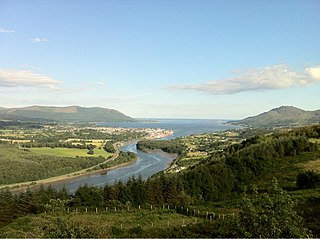
Carlingford Lough is a glacial fjord or sea inlet in northeastern Ireland, forming part of the border between Northern Ireland to the north and the Republic of Ireland to the south. On its northern shore is County Down, the Mourne Mountains, and the town of Warrenpoint; on its southern shore is County Louth, the Cooley Mountains and the village of Carlingford. The Newry River flows into the loch from the northwest.

<span class="mw-page-title-main">Hilltown, County Down</span> Village in County Down, Northern Ireland

Hilltown is a small village within the townland of Carcullion in County Down, Northern Ireland. Hilltown is the main village of the parish of Clonduff which contains the village and the rural areas around it at one end, and the rural enclave of Cabra at the other end of the parish. It had a population of 899 people in the 2001 census. On 27 March 2011, the usually resident population of Hilltown was 1,709.

<span class="mw-page-title-main">Carlingford, County Louth</span> Town on the Cooley Peninsula, County Louth, Ireland

Carlingford is a coastal town and civil parish in northern County Louth, Ireland. For the purposes of local government, the town is part of the Dundalk Municipal District. It is situated on the southern shore of Carlingford Lough with Slieve Foy mountain as a backdrop, sometimes known as Carlingford Mountain. It is the main town on the Cooley Peninsula. Located on the R176/R173 roads between Greenore and Omeath village, Carlingford is approximately 27 km (17 mi) north east from Dundalk, 90 km (56 mi) north of Dublin and 11 km (7 mi) south of the border with Northern Ireland. Carlingford won the Irish Tidy Towns Competition in 1988.

<span class="mw-page-title-main">Slieve Foy</span> Mountain in Louth, Ireland

Slieve Foy or Slieve Foye is a mountain on the Cooley Peninsula in Louth, Ireland. It rises to 589 metres (1,932 ft), making it the highest of the Cooley Mountains and the highest in Louth. It overlooks Carlingford Lough and the village of Carlingford, and is sometimes called Carlingford Mountain.

<span class="mw-page-title-main">Glenfarne</span> Village in County Leitrim, Ireland

Glenfarne or Glenfarn is a village in north County Leitrim, Ireland. It is the site of the original Ballroom of Romance, which inspired a short story by William Trevor that was subsequently turned into a television film in a BBC/RTÉ co-production. Glenfarne has a lakeside forest near Lough MacNean. The village is located on the N16 (Sligo–Blacklion) road, 13 km east of Manorhamilton.

<span class="mw-page-title-main">Cloughmore</span>

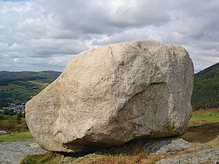
Cloughmore or Cloghmore, known locally as "The Big Stone", is a huge granite boulder perched on a mountainside almost 1,000 feet (300 m) above the village of Rostrevor, County Down, Northern Ireland. It sits on the slopes of Slieve Martin in Kilbroney Park, overlooking Rostrevor Forest, Carlingford Lough and the Cooley Peninsula. It is popular destination for visitors, and is part of a National Nature Reserve and Area of Special Scientific Interest.

<span class="mw-page-title-main">Newry railway station</span> Railway station in County Armagh, Northern Ireland

Newry railway station serves Newry and Bessbrook in Northern Ireland. The station is located in the northwest of Newry, County Armagh on the Dublin-Belfast line close to the Craigmore Viaduct. It is the most southerly railway station in Northern Ireland.

<span class="mw-page-title-main">Ballymascanlan</span> Village in County Louth, Ireland

Ballymascanlan, otherwise Ballymascanlon, is a small village and townland in County Louth, Ireland. It is 4 km (2.5 mi) north-east of Dundalk on the Cooley Peninsula, on the road to Carlingford. The village is in a civil parish of the same name.

<span class="mw-page-title-main">Cooley Peninsula</span> Peninsula in County Louth, Ireland

The Cooley Peninsula is a hilly peninsula in the north of County Louth on the east coast of Ireland; the peninsula includes the small town of Carlingford, the port of Greenore and the village of Omeath.

<span class="mw-page-title-main">Mullaghbawn</span> Village in County Armagh, Northern Ireland

Mullaghbawn, or Mullaghbane, is a small village and townland near Slieve Gullion in County Armagh, Northern Ireland. In the 2011 Census it had a population of 596. At the 2021 Census this had risen to 642.

Saint Brónach was a 6th-century holy woman from Ireland, the reputed founder and patron saint of Cell Brónche, now Kilbroney, in County Down, Northern Ireland.

<span class="mw-page-title-main">Rostrevor Forest</span>

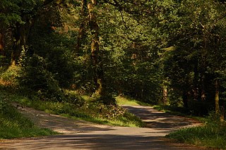
Rostrevor Forest is located near the village of Rostrevor, County Down, Northern Ireland. It lies between the Mourne Mountains and Carlingford Lough, in the Mourne Area of Outstanding Natural Beauty. The first trees, primarily sitka spruce, douglas fir and pine, were planted in 1931. The Forest Service carries out felling in the forest and replants trees with wildlife conservation in mind. Animal species found in the forest include red and grey squirrels, foxes, badgers, jays and sparrow hawks.

<span class="mw-page-title-main">Kilbroney Park</span> Public park in Northern Ireland

Kilbroney Park is a park near Rostrevor in Northern Ireland. Formerly a country estate, it was visited by William Makepeace Thackeray, Charles Dickens and Seamus Heaney and may have been the inspiration for Narnia in the writings of C. S. Lewis. It came into the ownership of the Bowes-Lyon family, and the future Queen Elizabeth II and Princess Margaret holidayed there as children. The park has been run by Newry, Mourne and Down District Council since 1977 and features a children's play area, tennis courts and a cafe. It has a large collection of rare and historic trees, including "Old Homer", a holm oak that was voted Northern Ireland's Tree of the Year in 2016. A glacial erratic in the park is connected with the legend of the giant Finn Mac Cool.

<span class="mw-page-title-main">Newry, Warrenpoint and Rostrevor Railway</span> Defunct railway in Ireland

The Newry, Warrenpoint and Rostrevor Railway (NW&RR) was a former railway line linking Newry and the port of Warrenpoint on the Carlingford Lough inlet in Ireland, and the company operating it. The railway was absorbed into the Great Northern Railway of Ireland in 1886 and the line closed in 1965.

References

  1. 1 2 "Ros Treabhair/Rostrevor". Placenames Database of Ireland (logainm.ie). Retrieved 20 July 2022.
  2. 1 2 "Census 2011 Population Statistics for Rostrevor Settlement". Northern Ireland Statistics and Research Agency (NISRA). Retrieved 21 June 2021. UKOpenGovernmentLicence.svg This article contains quotations from this source, which is available under the Open Government Licence v3.0. © Crown copyright.
  3. 1 2 3 4 "Placenames NI: Rostrevor" . Retrieved 16 March 2023.
  4. "Raymonds County Down" . Retrieved 18 September 2014.
  5. "Calendar of Irish Saints". 19 May 2014. Archived from the original on 19 May 2014. Retrieved 6 November 2022.
  6. "The Hidden Bell of Bronach Kilbroney". The Last Leprechauns of Ireland. Retrieved 6 November 2022.
  7. Somerled the Great Sea Lord, http://cunninghamh.tripod.com/somerled/somerled.html
  8. "Somerled".
  9. "Rooted in history ... idyllic corner of Northern Ireland which is a haven of peace and even hosted the Queen". Belfast Telegraph. 14 September 2018. Retrieved 7 November 2018.
  10. "Rostrevor station" (PDF). Railscot - Irish Railways. Retrieved 24 November 2007.

Commons-logo.svg Media related to Rostrevor at Wikimedia Commons