Rother Valley

Last updated

The Rother Valley is the valley of the River Rother, of which there are at least three in England. Rother Valley may refer to:

England Country in north-west Europe, part of the United Kingdom

England is a country that is part of the United Kingdom. It shares land borders with Wales to the west and Scotland to the north-northwest. The Irish Sea lies west of England and the Celtic Sea lies to the southwest. England is separated from continental Europe by the North Sea to the east and the English Channel to the south. The country covers five-eighths of the island of Great Britain, which lies in the North Atlantic, and includes over 100 smaller islands, such as the Isles of Scilly and the Isle of Wight.

Rother Valley (UK Parliament constituency) Parliamentary constituency in the United Kingdom

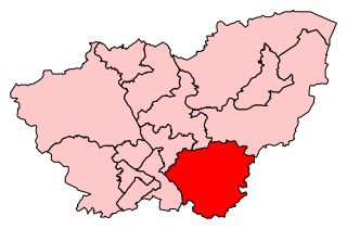
Rother Valley is a constituency represented in the House of Commons of the UK Parliament since 1983 by Kevin Barron, a member of the Labour Party.

Rother Valley Country Park

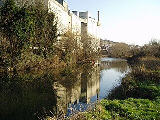
The Rother Valley Country Park is a country park in the Metropolitan Borough of Rotherham, South Yorkshire, close to Rotherham's border with Sheffield and Derbyshire. It covers 3 square kilometres, has four artificial lakes, recreational activities and nature reserves. The majority of the park is on the site of a former quarry, with the main excavation sites filled by the artificial lakes. There is still much of the original quarry machinery below the water.

Rother Valley Railway

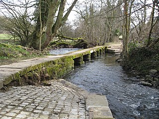
The Rother Valley Railway (RVR) is a heritage railway project based at Robertsbridge in East Sussex, England. It takes its name from the original name for what later became the Kent and East Sussex Railway, running from Robertsbridge through to Headcorn in Kent, via Tenterden. The project is to replace the ‘missing link’ between Robertsbridge, a station on the Tonbridge to Hastings mainline, and Bodiam on the Kent and East Sussex Railway, a heritage railway which operates from Bodiam to Tenterden. A charity supported by a society of volunteers are attempting to re-establish the railway link. The RVR began by reinstating the first few hundred yards of line eastwards from Robertsbridge, and also a short stretch westwards from Bodiam. In 2010, the latter section was further extended to reach Junction Road. In summer 2011 work began at Robertsbridge to extend further eastwards to Northbridge Street, which entailed the rebuilding of five bridges. By June 2012, this further extension was also completed. In September 2013, a Gala weekend at Robertsbridge marked the progress to date and the start of the next phase - the re-instatement of the section between Northbridge Street and Junction Road, for which statutory permissions are being sought. While the RVR does not yet feature regular passenger trains, the base at Robertsbridge houses a small shop and visitor centre open to the public each Sunday, utilising a building formerly used as the London terminus of the Orient Express. There is also a small collection of historic railway vehicles in various stages of preservation.

See also:

Related Research Articles

South Yorkshire County of England

South Yorkshire is a metropolitan county in England. It is the southernmost county in the Yorkshire and the Humber region and had a population of 1.34 million in 2011. It has an area of 1,552 square kilometres (599 sq mi) and consists of four metropolitan boroughs, Barnsley, Doncaster, Rotherham and Sheffield. South Yorkshire was created on 1 April 1974 as a result of the Local Government Act 1972.Its largest settlement is Sheffield.

Derwent derives from the Brythonic term Derventio, meaning "valley thick with oaks". It may refer to:

River Sheaf river in the United Kingdom

The River Sheaf is a river in Sheffield, South Yorkshire, England. Its source is the union of the Totley Brook and the Old Hay Brook in Totley, now a suburb of Sheffield. It flows northwards, past Dore, through the valley called Abbeydale and north of Heeley. It then passes into a culvert, through which it flows under the centre of Sheffield emerging just once before joining the River Don near Blonk Street Bridge. This lower section of the River Sheaf together with the River Don, between the present Blonk Street and Lady's Bridges, formed two sides of the boundary of Sheffield Castle.

River Rother, South Yorkshire river in South Yorkshire

The River Rother, a waterway in the northern midlands of England, gives its name to the town of Rotherham and to the Rother Valley parliamentary constituency. It rises near Clay Cross in Derbyshire and flows in a generally northwards direction through the centre of Chesterfield, where it feeds the Chesterfield Canal, and on through the Rother Valley Country Park and several districts of Sheffield before joining the River Don at Rotherham in Yorkshire.

The Moss river in the United Kingdom

The Moss is a brook in North East Derbyshire, England.

River Amber river in Derbyshire, United Kingdom

The River Amber is a left bank tributary of the River Derwent in Derbyshire, England. It gives its name to the local government district and borough of Amber Valley.

Treeton farm village in the United Kingdom

Treeton is a village and civil parish of the Metropolitan Borough of Rotherham in South Yorkshire, England. It is located about 4 miles (6 km) south of the town of Rotherham and 5 miles (8 km) east of Sheffield City Centre.

Gleadless Valley (ward) electoral ward of Sheffield City Council

Gleadless Valley ward—which includes the districts of Gleadless Valley, Heeley, Lowfield, and Meersbrook—is one of the 28 electoral wards in City of Sheffield, England. It is located in the southern part of the city and covers an area of 4.5 km2. The population of this ward in 2011 was 21,089 people in 9,516 households. It is one of the five wards that form the Sheffield Heeley parliamentary constituency whose Member of Parliament elected at the 2001 general election was Meg Munn. Gleadless Valley actually describes the valley that separates Hemsworth from Herdings, and is a broad area that covers several housing estates: Hemsworth, Herdings and Rollestone. Gleadless Valley is bordered by Gleadless and Norton.

Killamarsh town and civil parish in North East Derbyshire, England

Killamarsh is a town and civil parish in North East Derbyshire, England, bordering Sheffield and South Yorkshire to the North West. Killamarsh is surrounded by, in a clockwise direction from the north, Rother Valley Country Park, Wales, Kiveton, Woodall, Harthill, Barlborough, Spinkhill, Renishaw, Eckington, and the Sheffield suburbs of Oxclose, Halfway and Holbrook. Over the years, Sheffield and South Yorkshire have tried to merge the town into the ceremonial county as part of the city, but disagreements have prevented this, though Killamarsh does have a Sheffield dialling code, address and postcode.

Rother Link

The Rother Link is a planned English canal that would connect the Chesterfield Canal at Killamarsh, via the River Rother through to the Sheffield and South Yorkshire Navigation, thus creating a new cruising ring and encouraging boats to visit the Chesterfield Canal.

Yorkshire South (European Parliament constituency) constituency of the European Parliament

Yorkshire South was a European Parliament constituency covering most of South Yorkshire in England.

Rotherham town in South Yorkshire, England

Rotherham is a town in South Yorkshire, England, which together with its conurbation and outlying settlements to the north, south and south-east forms the Metropolitan Borough of Rotherham, with a recorded population of 257,280 in the 2011 census. Historically in the West Riding of Yorkshire, its central area is on the banks of the River Don below its confluence with the Rother on the traditional road between Sheffield and Doncaster. Rotherham was well known as a coal mining town as well as a major contributor to the steel industry.

River Hipper river in the United Kingdom

The River Hipper is a tributary of the River Rother in Derbyshire, England. Its source is a large expanse of wetlands, fed by the surrounding moors between Chatsworth and Chesterfield, known as the Hipper Sick on Beeley Moor, which is part of the Chatsworth Estate. It then passes through Holymoorside and down into Chesterfield, just south of the town centre, before flowing into the River Rother. In July 2007, parts of Chesterfield flooded when the River Hipper burst its banks during a substantial storm that caused extensive flooding in North Derbyshire and South Yorkshire.

River Drone river in the United Kingdom

The River Drone is a river which flows south from its source on the Sheffield, South Yorkshire border. It flows through Dronfield, Unstone and Unstone Green in Derbyshire before merging at Sheepbridge to the north of Chesterfield with the Barlow Brook. It then flows south east till it merges with the River Rother at Brimington Road North (B6050) at Chesterfield. It is one of the three main tributaries of the Rother.

Shire Brook

Shire Brook is a small stream in the south eastern part of the City of Sheffield in South Yorkshire, England. It rises in the suburb of Gleadless Townend and flows in a general easterly direction for 4 miles (6.5 km) to its confluence with the River Rother between Beighton and Woodhouse Mill. In the past the brook has been both the border of Yorkshire and Derbyshire and between the sees of Canterbury and York. The course of the stream has been influenced by human intervention in the 20th century with the brook being diverted underground and flowing through culverts on three occasions as it traverses locations which were formerly landfill sites and extensive railway sidings.