
Snohomish County is a county located in the U.S. state of Washington. With a population of 827,957 as of the 2020 census, it is the third-most populous county in Washington, after nearby King and Pierce counties, and the 72nd-most populous in the United States. The county seat and largest city is Everett. The county forms part of the Seattle metropolitan area, which also includes King and Pierce counties to the south.

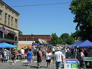
Arlington is a city in northern Snohomish County, Washington, United States, part of the Seattle metropolitan area. The city lies on the Stillaguamish River in the western foothills of the Cascade Range, adjacent to the city of Marysville. It is approximately 10 miles (16 km) north of Everett, the county seat, and 40 miles (64 km) north of Seattle, the state's largest city. As of the 2020 U.S. census, Arlington had a population of 19,868; its estimated population is 20,075 as of 2021.

Granite Falls is a city in Snohomish County, Washington, United States. It is located between the Pilchuck and Stillaguamish rivers in the western foothills of the Cascade Range, northeast of Lake Stevens and Marysville. The city is named for a waterfall north of downtown on the Stillaguamish River, also accessible via the Mountain Loop Highway. It had a population of 3,364 at the 2010 census.

Lake Stevens is a city in Snohomish County, Washington, United States, that is named for the lake it surrounds. It is located 6 miles (9.7 km) east of Everett and borders the cities of Marysville to the northwest and Snohomish to the south. The city's population was 35,630 at the 2020 census.

Lynnwood is a city in Snohomish County, Washington, United States. The city is part of the Seattle metropolitan area and is located 16 miles (26 km) north of Seattle and 13 miles (21 km) south of Everett, near the junction of Interstate 5 and Interstate 405. It is the fourth-largest city in Snohomish County, with a population of 38,568 in the 2020 U.S. census.

Monroe is a city in Snohomish County, Washington, United States. It is located at the confluence of the Skykomish, Snohomish, and Snoqualmie rivers near the Cascade foothills, about 30 miles (48 km) northeast of Seattle. Monroe's population was 19,699 as of the 2020 census.
Snohomish is a city in Snohomish County, Washington, United States. The population was 10,126 at the 2020 census. It is located on the Snohomish River, southeast of Everett and northwest of Monroe. Snohomish lies at the intersection of U.S. Route 2 and State Route 9. The city's airport, Harvey Airfield, is located south of downtown and used primarily for general aviation.
Lake Goodwin is a lake in Snohomish County, Washington, United States. The surrounding census district of Lake Goodwin, Washington is named after the lake.

Ridgefield National Wildlife Refuge is a National Wildlife Refuge and is overseen by the United States Fish and Wildlife Service. The refuge borders the Columbia River and is located west of the city of Ridgefield, Washington. The wildlife haven is split by Lake River. The refuge, which provides a year-round habitat and a migration stop for a variety of bird species, protects more than 5,200 acres (2,100 ha) of marshes, grasslands, and woodlands

Glacier Peak Wilderness is a 566,057-acre (229,075 ha), 35-mile-long (56 km), 20-mile-wide (32 km) wilderness area located within portions of Chelan, Snohomish, and Skagit counties in the North Cascades of Washington. The area lies within parts of Wenatchee National Forest and Mount Baker National Forest and is characterized by heavily forested stream courses, steep-sided valleys, and dramatic glacier-crowned peaks. The dominant geologic feature of the area is 10,541-foot (3,213 m) Glacier Peak. It is the most remote major volcanic peak in the Cascade Range and has more active glaciers than any other place in the lower forty-eight states. Glacier Peak is a volcanic cone of basalt, pumice, and ash which erupted during periods of heavy glaciation.

The Upper Mississippi River National Wildlife and Fish Refuge is a 240,000-acre (970 km2), 261-mile long (420 km) National Wildlife Refuge located in and along the Upper Mississippi River. It runs from Wabasha, Minnesota in the north to Rock Island, Illinois in the south.

The Plum Island Range Lights are a pair of range lights located on Plum Island in Door County, Wisconsin. Plum Island was transferred to the United States Fish and Wildlife Service in 2007 and became part of the Green Bay National Wildlife Refuge. Plum Island is seasonally open to the public for day-time use.

Malheur National Wildlife Refuge is a National Wildlife Refuge located roughly 30 miles (48 km) south of the city of Burns in Oregon's Harney Basin. Administered by the United States Fish and Wildlife Service, the refuge area is roughly T-shaped with the southernmost base at Frenchglen, the northeast section at Malheur Lake and the northwest section at Harney Lake.
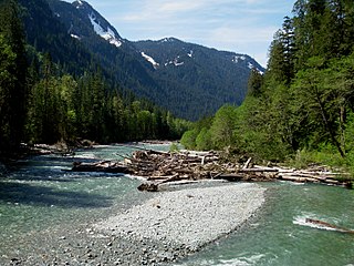
The Baker River is an approximately 30-mile (48 km), southward-flowing tributary of the Skagit River in northwestern Washington in the United States. It drains an area of the high North Cascades in the watershed of Puget Sound north of Seattle, and east of Mount Baker. With a watershed of approximately 270 square miles (700 km2) in a complex of deep valleys partially inside North Cascades National Park, it is the last major tributary of the Skagit before the larger river reaches its mouth on Skagit Bay. The river flows through Concrete, Washington, near its mouth and has two hydroelectric dams owned by Puget Sound Energy.

The Culmback Dam is a large rockfill hydroelectric and water supply dam on the Sultan River, a tributary of the Skykomish River, in Washington. Built in 1965, the dam is 640 feet (200 m) long at the crest and 262 feet (80 m) high. Its reservoir, Spada Lake, provides water for 70 to 75 percent of Snohomish County and feeds the Jackson Hydro Project, providing 112 megawatts of clean energy to Snohomish county. Some critics charge that the dam has strongly impacted the runs of salmon and other migratory fish in the Sultan River by depleting gravel and sediment needed to line the riverbed. The dam's operator counters that Culmback Dam dramatically reduces flooding events, benefiting fish populations and the surrounding communities. The dam was named in honor of George Culmback, a former mayor of Everett.

Wapato Lake is a restored historic lake located in what became parts of Washington County and Yamhill County in the U.S. state of Oregon. The area was sometimes known as Wapato Lake Bed and Wapato Flat. The lake is located about a half mile east of Gaston at 55 metres (180 ft) elevation. The lake bed soils contain a layer of organic peat that once supported a wetland community dominated by the wapato plant, Sagittaria latifolia, particularly in the upper marsh areas. Wapato plants were reintroduced to the restored lake by tribal people from the Grand Ronde Reservation in preparation for the opening of the Wapato Lake National Wildlife Refuge in March 2023.

Conboy Lake National Wildlife Refuge is located on the east slope of the Cascade Mountains at the base of 12,281-foot (3,743 m) Mount Adams in southern Washington state.

Goat Lake is a glacial lake located in Snohomish County, Washington and in the Mount Baker-Snoqualmie National Forest. The lake is a popular area for hiking, backpacking, and fishing.

Lake Serene is an alpine lake located in Snohomish County, Washington near Mount Index and above Bridal Veil Falls. The lake is a popular area for hiking and fishing.


