Fenwick Island is a coastal town in Sussex County, Delaware, USA. According to 2010 census figures, the population of the town is 379, a 10.8% increase over the last decade. It is part of the Salisbury, Maryland-Delaware Metropolitan Statistical Area. The town is located on Fenwick Island, a barrier spit.

The Maryland Transit Administration (MTA) is a state-operated mass transit administration in Maryland, and is part of the Maryland Department of Transportation. It is better known as MTA Maryland to avoid confusion with other cities' transit agencies who share the initials MTA. The MTA operates a comprehensive transit system throughout the Baltimore-Washington Metropolitan Area. There are 80 bus lines serving Baltimore's public transportation needs, along with other services that include the Light Rail, Metro Subway, and MARC Train. With nearly half the population of Baltimore residents lacking access to a car, the MTA is an important part of the regional transit picture. The system has many connections to other transit agencies of Central Maryland, Washington, D.C., Northern Virginia, and south-central Pennsylvania : WMATA, Charm City Circulator, Regional Transportation Agency of Central Maryland, Annapolis Transit, Rabbit Transit, Ride-On, and TransIT.

College Park–University of Maryland is a Washington Metro station in Prince George's County, Maryland on the Green Line. It also serves MARC's Camden Line.

A business route in the United States is a short special route connected to a parent numbered highway at its beginning, then routed through the central business district of a nearby city or town, and finally reconnecting with the same parent numbered highway again at its end.

Maryland Route 5 is a 74.34-mile (119.64 km) long state highway that runs north–south in the U.S. state of Maryland. The highway runs from Point Lookout in St. Mary's County north to the Washington, D.C. border in Suitland, Prince George's County. MD 5 begins as the two-lane undivided Point Lookout Road which runs from Point Lookout, St. Mary's County, to an intersection with MD 235 in the northern part of the county. Point Lookout Road passes through rural areas as well as the county seat of Leonardtown. After the MD 235 intersection, the route becomes the four-lane divided Three Notch Road and continues into Charles County, where it becomes Leonardtown Road. Here, the route bypasses Hughesville and continues north toward the Waldorf area, which it bypasses to the east on Mattawoman Beantown Road. The route merges onto U.S. Route 301 and enters Prince George's County, splitting from US 301 at an interchange in Brandywine. From here, MD 5 continues north on Branch Avenue, running through suburban areas, before becoming a freeway as it passes Andrews Air Force Base and interchanges with Interstate 95 (I-95)/I-495. Past the Capital Beltway, the route runs through suburban areas of Hillcrest Heights and Suitland before reaching the D.C. border, where Branch Avenue continues, crossing Pennsylvania Avenue and eventually terminating at Randle Circle.

U.S. Route 50 is a major east–west route of the U.S. Highway system, stretching just over 3,000 miles (4,800 km) from Ocean City, Maryland on the Atlantic Ocean to West Sacramento, California. In the U.S. state of Maryland, US 50 exists in two sections. The longer of these serves as a major route connecting Washington, D.C. with Ocean City; the latter is the eastern terminus of the highway. The other section passes through the southern end of Garrett County for less than 10 miles (16 km) as part of the Northwestern Turnpike, entering West Virginia at both ends. One notable section of US 50 is the dual-span Chesapeake Bay Bridge across the Chesapeake Bay, which links the Baltimore–Washington metropolitan area with the Eastern Shore region, allowing motorists to reach Ocean City and the Delaware Beaches.

Washington, D.C. has a number of different modes of transportation available for use. Commuters have a major influence on travel patterns, with only 28% of people employed in Washington, D.C. commuting from within the city, whereas 33.5% commute from the nearby Maryland suburbs, 22.7% from Northern Virginia, and the rest from Washington, D.C.'s outlying suburbs.

U.S. Route 13 is a U.S. Highway running from Fayetteville, North Carolina north to Morrisville, Pennsylvania. In the U.S. state of Maryland, the route runs 42.48 mi (68.36 km) from the Virginia border south of Pocomoke City in Worcester County north to the Delaware border in Delmar, Wicomico County, where the route intersects Route 54, which runs along the state line. The majority of the route within Maryland is a four-lane divided highway that passes through rural areas of woodland and farmland. The route also runs through a few municipalities including Pocomoke City and Princess Anne and it bypasses Salisbury and Fruitland to the east on the Salisbury Bypass, which is a freeway. US 13 intersects many major roads including the southern terminus of US 113 in Pocomoke City, Maryland Route 413 in Westover, and MD 12 and US 50 where the route is on the Salisbury Bypass. The route shares a concurrency with US 50 along a portion of the Salisbury Bypass.

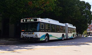
Route 91 is a bus route operated by the Maryland Transit Administration in Baltimore. The line currently runs from Sinai Hospital to City Hall, serving the communities of Pimlico, Arlington, Walbrook, and Bolton Hill, Coppin State College and the corridors of Garrison Boulevard and Eutaw Place. The line has the second-highest farebox recovery rate of all MTA bus lines.
Route 20 is a bus route operated by the Maryland Transit Administration in Baltimore and its suburbs. The line currently runs from Security Square Mall east through downtown Baltimore to Baltimore City Hall. The main roads on which the line operates are Old Frederick Road, Baltimore Street, Fayette Street, and Boston Street. The line serves the communities of Westview, Edmondson Village.
Several special routes of U.S. Route 1 exist, from Florida to Maine. In order from south to north, separated by type, these special routes are as follows.
U.S. Route 13 runs along the Atlantic coastline for over 500 miles (800 km), passing through five states. Along its route, it possessed numerous special routes, which are all loops off the mainline US 13. At present, there are at least fourteen special routes in existence: two in North Carolina, five in Virginia, two in Maryland, four in Delaware, and one in Pennsylvania. Seven others have existed in the past, but have been deleted.

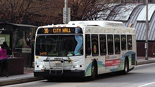
Route 30 was a bus route operated by the Maryland Transit Administration in Baltimore. The line ran from Edmondson Village in west Baltimore to Bayview Medical Center in southeast Baltimore during rush hour and City Hall during the midday until 20 February 2015.
U.S. Route 40 has at least nine extant special routes.
Several special routes of U.S. Route 220 exist. In order from south to north they are as follows.
Several special routes of U.S. Route 15 exist. In order from south to north they are as follows.

Mount Holly is a neighborhood in the Southwest District of Baltimore, located between the neighborhoods of Fairmont (south), Walbrook (east) and Garwyn Oaks (north). Its boundaries are drawn by Denison Street (east), Clifton Avenue (southwest), Gwynns Falls Parkway (north), Windsor Mill Road (northwest), and West North Avenue (south). Gwynns Falls Leakin Park is located to the west of Mount Holly.
Route 210 is an express bus route that operates to downtown Baltimore and Johns Hopkins Hospital from Annapolis and Kent Island on the Eastern Shore of Maryland.
Route 215 is an express bus route that operates from downtown Baltimore and Johns Hopkins Hospital to Annapolis. Route 215 also connects to Cromwell Station in Glen Burnie, providing an additional Annapolis connection to Light Rail passengers and nearby residents.


