
The Maryland Transit Administration (MTA) is a state-operated mass transit administration in Maryland, and is part of the Maryland Department of Transportation. It is better known as MTA Maryland to avoid confusion with other cities' transit agencies who share the initials MTA. The MTA operates a comprehensive transit system throughout the Baltimore-Washington Metropolitan Area. There are 80 bus lines serving Baltimore's public transportation needs, along with other services that include the Light Rail, Metro Subway, and MARC Train. With nearly half the population of Baltimore residents lacking access to a car, the MTA is an important part of the regional transit picture. The system has many connections to other transit agencies of Central Maryland, Washington, D.C., Northern Virginia, and south-central Pennsylvania : WMATA, Charm City Circulator, Regional Transportation Agency of Central Maryland, Annapolis Transit, Rabbit Transit, Ride-On, and TransIT.
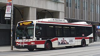
A transit bus is a type of bus used on shorter-distance public transport bus services. Several configurations are used, including low-floor buses, high-floor buses, double-decker buses, articulated buses and midibuses.
Howard Transit was the primary public transit system in Howard County, Maryland, which grew from the former ColumBus bus system in Columbia, Maryland. First Transit replaced Veolia Transport as the operating company in July 2007.
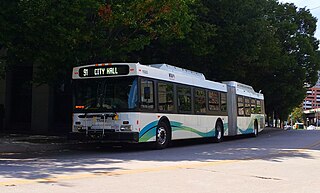
Route 91 is a bus route operated by the Maryland Transit Administration in Baltimore. The line currently runs from Sinai Hospital to City Hall, serving the communities of Pimlico, Arlington, Walbrook, and Bolton Hill, Coppin State College and the corridors of Garrison Boulevard and Eutaw Place. The line has the second-highest farebox recovery rate of all MTA bus lines.
Route 51 is a bus route operated by the Maryland Transit Administration in Baltimore and its suburbs. The line currently runs from the center of Towson to the Inner Harbor in Downtown Baltimore, serving the Charles Street corridor. Route 51 replaced Route 11 on June 18, 2017 due to the BaltimoreLink bus system overhaul.
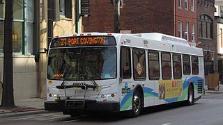
Route 27 is a bus route operated by the Maryland Transit Administration in Baltimore. The line currently runs from the Reisterstown Plaza Metro Subway Station in northwest Baltimore to Port Covington in South Baltimore through downtown. The line also serves the communities of Pimlico, Mt. Washington, Cross Keys, Hampden, and Cherry Hill, and the Greyhound bus terminal. The bus route is the successor to the 10 Roland Park, 12 Westport, and 25 Mount Washington streetcar lines.
The Maryland Transit Administration provides the primary public bus service for the Baltimore Metropolitan Area and commuter bus service in other parts of the state of Maryland. There are currently 76 bus routes, which include 43 LocalLink routes, 12 High Frequency CityLink Routes routes, 9 express bus routes, 19 commuter bus routes, and 5 Intercounty Connector or "ICC" routes. The local and commuter bus routes operate in conjunction with one subway line, three light rail lines, MARC train service, and various connections to other transit agencies.
A free travel pass is the privilege of a certain class of passengers to use a public transport service without paying a fare or presenting a ticket. They may need to present an identification card produced by their employer or other sponsoring organization, or by the transit provider.

BWI Business District station is a Baltimore Light Rail station in the BWI Business District, north of the Baltimore-Washington International Airport in Linthicum, Maryland. There are currently 36 free public parking spaces and connections can be made to MTA Maryland's Route 17 and 99 buses, WMATA's B30 express bus, and Howard Transit's Silver Route from this station. Additionally, portions of the BWI Trail can be found across the street from the parking lot.

LocalLink 36 is a bus route operated by the Maryland Transit Administration in Baltimore and its suburbs. The line currently runs from Towson to Fox Ridge, serving Parkville, Overlea, Rosedale, and Essex, and the Essex campus of the Community College of Baltimore County.
Annapolis Transit is a public transportation service of the Annapolis, Maryland Department of Transportation. It provides seven fixed-routes and one free-fare circulator service to provide access between downtown Annapolis and its suburbs. The Maryland Transit Administration complements these routes, providing access to Baltimore via "local bus service" and/or Eastern Shore via "commuter bus lines".

Route 46 is a limited stop bus route, identified as a "Quickbus", operated by the Maryland Transit Administration in Baltimore. The line currently runs from the Cedonia Loop in Northeast Baltimore to the Paradise Loop, in Catonsville. Service operates every 15 minutes during rush hour only. The line serves the corridors of Frederick Avenue in West Baltimore, and Sinclair Lane/Cedonia Ave in Northeast Baltimore including the communities of Yale Heights, and Gwynns Falls in West Baltimore, and Berea and Parkside in East Baltimore.

Route 47 is a limited stop bus route, identified as a "Quickbus", operated by the Maryland Transit Administration in Baltimore. The line currently runs from the Overlea Loop in Northeast Baltimore to Walbrook Junction, in West Baltimore. Service operates every 15 minutes during rush hour only. The main roads on which it operates include Poplar Grove Street, Saratoga Street, Gay Street, and Belair Road. Service operates Monday–Friday, every 15 minutes, from 5:30 a.m.– 9:30 a.m. and 2:30 p.m.- 6:30 p.m.
Cameron Village is a neighborhood in the North District of Baltimore, located between the neighborhoods of Mid-Govans and Woodbourne Heights. Vaguely bell-shaped, its boundaries are marked by Bradhurst Road and E. Belvedere Avenue (north), Woodbourne Avenue (south), Lothian Road (west) and Northwood Drive (east).

Beverly Hills is a neighborhood in the Northeast District of Baltimore, located between the neighborhoods of Moravia-Walther, Arcadia and Lauraville. Its boundaries are drawn by Harford Road (west), Weaver Avenue (south), Harcourt Road (east), Moravia Road (northeast) and Grindon Avenue (north).

Mount Holly is a neighborhood in the Southwest District of Baltimore, located between the neighborhoods of Fairmont (south), Walbrook (east) and Garwyn Oaks (north). Its boundaries are drawn by Denison Street (east), Clifton Avenue (southwest), Gwynns Falls Parkway (north), Windsor Mill Road (northwest), and West North Avenue (south). Gwynns Falls Leakin Park is located to the west of Mount Holly.
Better Waverly is a neighborhood in the North District of Baltimore, located between the neighborhoods of Charles Village (west) and Coldstream-Homestead-Montebello (east). Its boundaries are marked by East 33rd Street (north), Exeter Hall Avenue (south), Greenmount Avenue (west) and Loch Raven Road (east).


