Interstate 30 (I-30) is a 366.76-mile-long (590.24 km) expressway in the southern states of Texas and Arkansas in the United States, part of the Interstate Highway System. I-30 travels from I-20 west of Fort Worth, Texas, northeast via Dallas, and Texarkana, Texas, to I-40 in North Little Rock, Arkansas. The highway parallels U.S. Route 67 (US 67) except for the portion west of downtown Dallas. Between the termini, I-30 has interchanges with I-35W, I-35E and I-45. I-30 is known as the Tom Landry Freeway between I-35W and I-35E, within the core of the Dallas–Fort Worth metroplex.
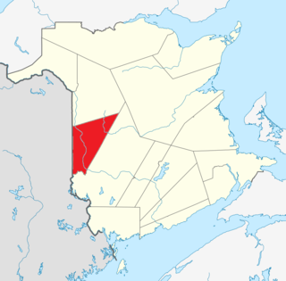
Carleton County is located in west-central New Brunswick, Canada.

Victoria County is located in northwestern New Brunswick, Canada. Farming, especially of potatoes, is the major industry in the county.

York County is located in west-central New Brunswick, Canada. The county contains the provincial capital, Fredericton. Outside the city, farming and forestry are two major industries in the county, which is bisected by the Saint John River. The Southwest Miramichi River flows through the northern section of the county.
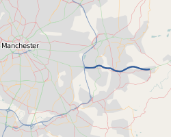
The M67 is a 5-mile (8.0 km) urban motorway in Greater Manchester, England, which heads east from the M60 motorway passing through Denton and Hyde before ending near Mottram. It was originally conceived as the first part of a trans-Pennine motorway between Manchester and Sheffield connecting the A57(M) motorway to the M1 motorway; however, the motorway never progressed this far.

U.S. Route 67 is a major north–south U.S. highway which extends 1,560-mile-long (2,511 km) in the Central United States. The southern terminus of the route is at the United States-Mexico border in Presidio, Texas, where it continues south as Mexican Federal Highway 16 upon crossing the Rio Grande. The northern terminus is at U.S. Route 52 in Sabula, Iowa.

U.S. Route 160 is a 1,465 mile (2,358 km) long east–west United States highway in the Midwestern and Western United States. The western terminus of the route is at US 89 five miles (8 km) west of Tuba City, Arizona. The eastern terminus is at US 67 and Missouri 158 southwest of Poplar Bluff, Missouri.
State Road 67 in the U.S. State of Indiana cuts a diagonal route from southwest to northeast across the state from the north side of Vincennes to Indianapolis to the Ohio state line, where it becomes State Route 29 east of Bryant.
Lindbergh Boulevard, named after the aviator, Charles Lindbergh, is a section of U.S. Routes 61 and 67 that extends through Missouri. Lindbergh Boulevard is home to Missouri's only traffic tunnel underneath a runway at Lambert–St. Louis International Airport.
Federal Route 67 is a federal road in Kedah, Malaysia, connecting Sungai Petani in the west to Baling in the east.

In the U.S. state of Illinois, U.S. Route 67 is a north–south highway through the western portions of the state. It runs from the Clark Bridge in Alton north to the Rock Island Centennial Bridge in Rock Island. It is the most direct route between St. Louis and the Quad Cities. This is a distance of 213.99 miles (344.38 km).
King's Highway 67, commonly referred to as Highway 67, is a provincially maintained highway in the northern portion of the Canadian province of Ontario that connects Highway 11 at Porquis Junction with the town of Iroquois Falls. The two-laned highway is 10.9 kilometres (6.8 mi) long and passes through farmland and swamps en route to the town. Highway 67 was assumed by the Department of Highways in 1937, shortly after the Department of Northern Development merged with it that year. The route originally extended south of Highway 11 to Highway 101 west of Timmins, but this portion was decommissioned as a provincial highway in 1998.
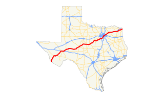
U.S. Route 67 is a major U.S. highway in the state of Texas. It runs from the US-Mexico Border south of Presidio to Texarkana at the Texas-Arkansas border. US 67 is part of the La Entrada al Pacifico international trade corridor from its southern terminus to US 385 in McCamey.

U.S. Route 67 is a U.S. highway running from Presidio, Texas northeast to Sabula, Iowa. In the U.S. state of Arkansas, the route runs 279.15 miles (449.25 km) from the Texas border in Texarkana northeast to the Missouri border near Corning. The route passes through several cities and towns, including Hope, Benton, Little Rock, Jacksonville, Cabot, Beebe, Walnut Ridge, and Pocahontas.
Numerous special routes of U.S. Route 67, all business routes, exist. One other route, formerly an alternate route in western Illinois, has since been downgraded to state Route 267.

Armstrong Glacier is a glacier flowing from the south side of Mount Bagshawe westward into George VI Sound. It provides the only known safe route for mechanical vehicles from George VI Sound to the Palmer Land plateau. It was named by the United Kingdom Antarctic Place-Names Committee for Edward B. Armstrong, British Antarctic Survey surveyor at Stonington Island, 1964–65.
U.S. Route 67 is the portion of a north-south highway in Missouri that starts at the Arkansas state line south of Neelyville and ends at the Illinois state line northeast of West Alton.
