The Maryland Transit Administration (MTA) is a state-operated mass transit administration in Maryland, and is part of the Maryland Department of Transportation. It is better known as MTA Maryland to avoid confusion with other cities' transit agencies who share the initials MTA. The MTA operates a comprehensive transit system throughout the Baltimore-Washington Metropolitan Area. There are 80 bus lines serving Baltimore's public transportation needs, along with other services that include the Light Rail, Metro Subway, and MARC Train. With nearly half the population of Baltimore residents lacking access to a car, the MTA is an important part of the regional transit picture. The system has many connections to other transit agencies of Central Maryland, Washington, D.C., Northern Virginia, and south-central Pennsylvania : WMATA, Charm City Circulator, Regional Transportation Agency of Central Maryland, Annapolis Transit, Rabbit Transit, Ride-On, and TransIT.
Madison Avenue Line refers to the following:
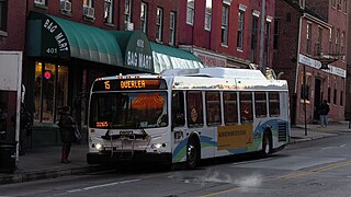
Route 15 is a bus route operated by the Maryland Transit Administration in Baltimore and its suburbs. The line currently runs from Security Square Mall, Westview Mall, Windsor Hills, or Walbrook Junction through downtown Baltimore and northeast to Overlea, with selected peak hour express trips to Perry Hall. The main roads on which it operates include Security Boulevard, Windsor Mill Road, Forest Park Avenue, Poplar Grove Street, Edmondson Avenue, Saratoga Street, Gay Street, and Belair Road, and is one of the most heavily used bus routes operated by the MTA.
Mondawmin station is a Metro SubwayLink station in Baltimore, Maryland. It is located under the intersection of Reisterstown Road and Liberty Heights Avenue in the Mondawmin neighborhood, adjacent to the Mondawmin Mall. It is the northernmost underground station on the line, and a major transfer point to many bus routes.
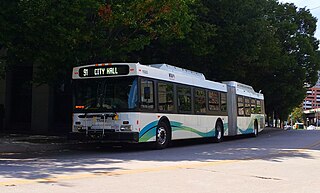
The Maryland Transit Administration provides the primary public bus service for the Baltimore Metropolitan Area and commuter bus service in other parts of the state of Maryland. There are currently 76 bus routes, which include 43 LocalLink routes, 12 High Frequency CityLink Routes routes, 9 express bus routes, 19 commuter bus routes, and 5 Intercounty Connector or "ICC" routes. The local and commuter bus routes operate in conjunction with one subway line, three light rail lines, MARC train service, and various connections to other transit agencies.

Lexington Market station is a Metro SubwayLink station in Baltimore, Maryland. It is one of 14 stops in the downtown Baltimore area. The station is a transportation hub, a designated transfer station to the Light RailLink Lexington Market station. The station is also served by a number of bus lines.
Walbrook is a neighborhood in West Baltimore, located along West North Avenue. Coppin State College is located in Walbrook.

LocalLink 29 is a bus route operated by the Maryland Transit Administration in Baltimore. The line currently runs from the Mondawmin Metro Subway Station in Northwest Baltimore to Brooklyn Homes in South Baltimore through the communities of Rosemont and the corridors of Hilton Street, Caton Avenue, and Patapsco Avenue. During peak hours, selected trips operate via Violetville Industrial Park.

Dorchester is a neighborhood in the Northwest District of Baltimore. It is located between the neighborhoods of Arlington (north), Central Forest Park (south), Howard Park (west) and Gallway-Garrison (east). Maryland Route 26 draws boundary between Dorchester and Central Forest Park. Dorchester's other boundaries are marked by Oakford Avenue, Eldorado Avenue and Garrison Boulevard.

Beverly Hills is a neighborhood in the Northeast District of Baltimore, located between the neighborhoods of Moravia-Walther, Arcadia and Lauraville. Its boundaries are drawn by Harford Road (west), Weaver Avenue (south), Harcourt Road (east), Moravia Road (northeast) and Grindon Avenue (north).
Callaway-Garrison is a neighborhood in the Northwest district of Baltimore, located between the neighborhoods of Dorchester (west) and Ashburton (east). Its boundaries are marked by West Cold Spring Lane (north), Liberty Heights Avenue (south), Callaway Avenue (east) and Garrison Boulevard (west).
Hanlon Longwood is a neighborhood in the Northwest District of Baltimore, located between the neighborhoods of Garwyn Oaks (west) and Burleigh–Leighton (east). It is bounded by North Dukeland Street (east), Garrison Boulevard (west) and the Gwynns Falls Parkway (south). The neighborhood's north boundary is marked by North Longwood Street, North Hilton Street and Liberty Heights Avenue.
Langston Hughes is a neighborhood in the Northwest District of Baltimore, located between the neighborhoods of Central Park Heights (east) and Woodmere. Its roughly pentagonal boundaries are marked by West Belvedere Avenue (northwest), Litchfield Avenue (northeast), Reisterstown Road (south) and Oakmont Avenue (east).
Westgate is a neighborhood in the Southwest District of Baltimore, located between Baltimore County (west) and the city neighborhood of Ten Hills (east). Its boundaries are marked by Baltimore National Pike (north), Frederick Avenue (south), Rock Glen Avenue and Edmondson Avenue (east) and the city line (west).
Mount Holly is a neighborhood in the Southwest District of Baltimore, located between the neighborhoods of Fairmont (south), Walbrook (east) and Garwyn Oaks (north). Its boundaries are drawn by Denison Street (east), Clifton Avenue (southwest), Gwynns Falls Parkway (north), Windsor Mill Road (northwest), and West North Avenue (south). Gwynns Falls Leakin Park is located to the west of Mount Holly.
Better Waverly is a neighborhood in the North District of Baltimore, located between the neighborhoods of Charles Village (west) and Coldstream-Homestead-Montebello (east). Its boundaries are marked by East 33rd Street (north), Exeter Hall Avenue (south), Greenmount Avenue (west) and Loch Raven Road (east).
Martz Group is an apportioned bus company headquartered in Wilkes-Barre, Pennsylvania, operating intercity commuter buses, charter buses, and tours. The company operates Martz Trailways, which is a part of the Trailways Transportation System. Martz Trailways provides intercity commuter bus service from the Wyoming Valley cities of Wilkes-Barre and Scranton and the Pocono Mountains in Northeastern Pennsylvania to New York City and Philadelphia. The company also runs buses connecting Northeastern Pennsylvania to the casinos in Atlantic City, New Jersey and Sands Casino Resort Bethlehem. Martz Group also operates the Gold Line commuter service and Gray Line sightseeing service in Washington, D.C., the National Coach Works in Fredericksburg, Virginia, and the First Class Coach Company Trailways serving Tampa and St. Petersburg in Florida.