
The Tropic of Cancer, which is also referred to as the Northern Tropic, is the most northerly circle of latitude on Earth at which the Sun can be directly overhead. This occurs on the June solstice, when the Northern Hemisphere is tilted toward the Sun to its maximum extent. It is currently 23°26′11.9″ (or 23.43664°) north of the Equator.

The Tropic of Capricorn is the circle of latitude that contains the subsolar point at the December solstice. It is thus the southernmost latitude where the Sun can be seen directly overhead. Its northern equivalent is the Tropic of Cancer.
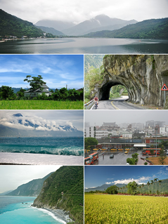
Hualien County is a county on the east coast of Taiwan. It is the largest county by area, yet due to its mountainous terrain, has one of the lowest populations in the country. The county seat and largest city is Hualien City.

Chiayi County is a county in southwestern Taiwan surrounding but not including Chiayi City. It is the sixth largest county in Taiwan.

The Taitung Line, also known as the Hua-Tung line, is the southern section of the Eastern Line of the Taiwan Railways Administration. The line starts at the Hualien station and ends at the Taitung station. It is 161.5 km long, including the main segment of 155.7 km between Hualien and Taitung.

Fengbin Township is a rural township located in Hualien County, Taiwan, bordering Taitung County. The Pacific Ocean lies to the east and the Hai'an Range to the west.

The Huadong Valley or Hualien–Taitung Valley, also known as East Rift Valley or the Longitudinal Valley, is a long and narrow valley located between the Central Mountain Range and the Coastal Mountain Range. It is also recognized as a plain area which stretches for about 180 kilometers near the eastern coast of Taiwan, passes from Hualien City at the north to Taitung City at the south. It was called Nakasendō Plain or simply Nakasendō during the era of Japanese rule.

Shoufeng Township is a rural township in Hualien County, Taiwan. The township sits in the north segment of Huadong Valley between Taiwan's Central Range and Hai'an Range near the Pacific Ocean. The township is best known as the location of National Dong Hwa University (NDHU), a university and famous tourist attraction in East Taiwan.

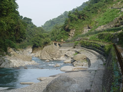
The Xiuguluan River is a river in southeastern Taiwan. It flows through the Huatung Valley for 81 km (50 mi) before emptying into the Pacific Ocean in Fengbin, Hualien.

Hualien is a railway station in Hualien City, Hualien County, Taiwan served by Taiwan Railways Administration. It is the terminal station of North-link line and the starting station of Taitung line.

Ruisui Township is a rural township located in southern Hualien County, Taiwan, and has a population of 12,107 inhabitants in 11 villages.
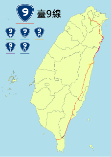
Provincial Highway No. 9 is an important highway across eastern Taiwan from Taipei City to Fangshan, Pingtung, Pingtung County. This provincial highway, at 476.1 km long, is the longest provincial highway in Taiwan and passes the regions of Taipei City, New Taipei City, Yilan County, Hualien County, Taitung County and Pingtung County.

Zhuoxi Township is a mountain indigenous township in Hualien County, Taiwan, bisected by the Tropic of Cancer. It lies on the Central Mountain Range with steep mountains which makes it the highest township in the county. The population is 6,210 inhabitants, including Bunun people, Truku people and Seediq people. The main economic activity is agriculture.
The 1972 Ruisui earthquake occurred on April 24 at 17:57 local time. The magnitude of this earthquake was given as 7.2 by the United States Geological Survey and 6.9 by the Central Weather Bureau of Taiwan. The epicenter was located near Ruisui Township, Hualien County, Taiwan. The intensity was shindo 4 in Taipei and Hualien. Five people were reported dead. The Ruisui Bridge was destroyed. The water treatment plant in Ruisui was damaged.

The Hoping Power Plant is a coal-fired power plant in Xiulin Township, Hualien County, Taiwan. With the installed capacity of 1,320 MW, the power plant is the fourth largest coal-fired power plant in Taiwan.
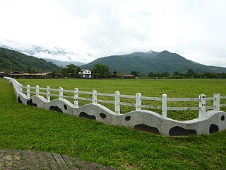
The Rareseed Ranch is a tourist attraction ranch in Wuhe Village, Ruisui Township, Hualien County, Taiwan.

Ruisui is a railway station on the Taiwan Railways Administration Hualien–Taitung line located in Ruisui Township, Hualien County, Taiwan.
Fuyuan National Forest Recreation Area, also reputed as the “Butterfly Valley”, is located in Fuyuan Village, Ruisui Township, Hualien County, Taiwan.

The Dongdamen Night Market or Dongdaemun Night Market is a night market in Hualien City, Hualien County, Taiwan. It is the largest night market in the county.

Fuyuan railway station is a railway station located in Ruisui Township, Hualien County, Taiwan. It is located on the Taitung line and is operated by the Taiwan Railways Administration.
