Rural Municipality of Coalfields No. 4

Last updated

Coalfields No. 4
Rural Municipality of Coalfields No. 4
Luscar Mining Maintenance Shop (625171768).jpg
SK RM 4 Coalfields.svg
Location of the RM of Coalfields No. 4 in Saskatchewan
Coordinates: 49°09′00″N102°39′25″W / 49.150°N 102.657°W / 49.150; -102.657 [1]
Country Canada
Province Saskatchewan
Census division 1
SARM division 1
Federal riding Souris—Moose Mountain
Provincial riding Estevan
Formed [2] January 1, 1913
Government
[3]
   Reeve Richard Tessier
  Governing bodyRM of Coalfields No. 4 Council
  AdministratorTerry Sernick
  Office location Bienfait
Area
 (2016) [4]
  Land819.52 km2 (316.42 sq mi)
Population
 (2016) [4]
  Total368
  Density0.4/km2 (1/sq mi)
Time zone CST
  Summer (DST) CST
Postal code
S0C 0M0
Area code(s) 306 and 639
Website rmofcoalfields.com OOjs UI icon edit-ltr-progressive.svg

The Rural Municipality of Coalfields No. 4 (2016 population: 368) is a rural municipality (RM) in the Canadian province of Saskatchewan within Census Division No. 1 and SARM Division No. 1. Located in the southeast portion of the province, it is adjacent to the United States, neighbouring Burke County, North Dakota.

Contents

History

The RM of Coalfields No. 4 was incorporated as a rural municipality on January 1, 1913. [2]

Geography

The Souris River is the only major river in the RM. It travels from Roche Percée in the west straight across to the east into the neighbouring RM of Enniskillen No. 3. There are no notable lakes in the RM of Coalfields.

Communities and localities

The following urban municipalities are surrounded by the RM.

Towns:

Villages:

The following unincorporated communities are within the RM:

Transportation

The two major highways to travers the RM of Coalfields No. 4 are Highway 18 and Highway 39. Municipal highways include Highway 604, Highway 605, Highway 703, and Highway 704.

Demographics

Population history
YearPop.±%
1981494    
1986498+0.8%
1991440−11.6%
1996 419−4.8%
2001 415−1.0%
2006 396−4.6%
2011 382−3.5%
2016 368−3.7%
Source: Statistics Canada via Saskatchewan Bureau of Statistics [5] [6]

In the 2021 Census of Population conducted by Statistics Canada, the RM of Coalfields No. 4 had a population of 330 living in 133 of its 157 total private dwellings, a change of

In the 2016 Census of Population, the RM of Coalfields No. 4 recorded a population of 368 living in 148 of its 183 total private dwellings, a

Government

The RM of Coalfields No. 4 is governed by an elected municipal council and an appointed administrator that meets on the third Thursday of every month. [3] The reeve of the RM is Richard Tessier while its administrator is Terry Sernick. [3] The RM's office is in Bienfait. [3]

Roche Percee Recreation Site

Roche Percee Recreation Site ( 49°04′34″N102°44′55″W / 49.0762°N 102.7485°W / 49.0762; -102.7485 ) [8] is a provincial campground in the RM of Coalfields along the Souris River. The park is treed and has a campground with 13 campsites and three picnic areas. The campground has non-electric sites, non-potable water, sewer disposal, and portable toilets. It is downstream and east of the village of Roche Percee and access is from Highway 39. [9]

See also

Related Research Articles

<span class="mw-page-title-main">Rural Municipality of Lomond No. 37</span> Rural municipality in Saskatchewan, Canada

The Rural Municipality of Lomond No. 37 is a rural municipality (RM) in the Canadian province of Saskatchewan within Census Division No. 2 and SARM Division No. 1. Located in the southeast portion of the province, it is south of the city of Weyburn.

<span class="mw-page-title-main">Rural Municipality of Milton No. 292</span> Rural municipality in Saskatchewan, Canada

The Rural Municipality of Milton No. 292 is a rural municipality (RM) in the Canadian province of Saskatchewan within Census Division No. 13 and SARM Division No. 6. Located in the west-central portion of the province, it is adjacent to the Alberta boundary.

<span class="mw-page-title-main">Rural Municipality of Fillmore No. 96</span> Rural municipality in Saskatchewan, Canada

The Rural Municipality of Fillmore No. 96 is a rural municipality (RM) in the Canadian province of Saskatchewan within Census Division No. 2 and SARM Division No. 1. It is located in the south-east portion of the province along Highway 33.

<span class="mw-page-title-main">Rural Municipality of Antler No. 61</span> Rural municipality in Saskatchewan, Canada

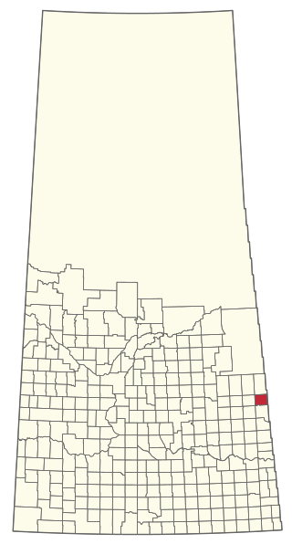
The Rural Municipality of Antler No. 61 is a rural municipality (RM) in the Canadian province of Saskatchewan within Census Division No. 1 and SARM Division No. 1.

<span class="mw-page-title-main">Rural Municipality of Bone Creek No. 108</span> Rural municipality in Saskatchewan, Canada

The Rural Municipality of Bone Creek No. 108 is a rural municipality (RM) in the Canadian province of Saskatchewan within Census Division No. 4 and SARM Division No. 3. It is located in the southwest portion of the province.

<span class="mw-page-title-main">Rural Municipality of Souris Valley No. 7</span> Rural municipality in Saskatchewan, Canada

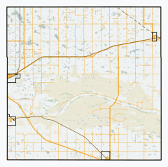
The Rural Municipality of Souris Valley No. 7 is a rural municipality (RM) in the Canadian province of Saskatchewan within Census Division No. 2 and SARM Division No. 1. Located in the southeast portion of the province, it is adjacent to the United States border, neighbouring Divide County in North Dakota.

Roche Percee is a village in the Canadian province of Saskatchewan within the RM of Coalfields No. 4 and Census Division No. 1. The village is near the Canada–United States border, just off Highway 39. Roche Percee is about 20 kilometres (12 mi) east of Estevan in the Souris River valley.

<span class="mw-page-title-main">Rural Municipality of Spalding No. 368</span> Rural municipality in Saskatchewan, Canada

The Rural Municipality of Spalding No. 368 is a rural municipality (RM) in the Canadian province of Saskatchewan within Census Division No. 14 and SARM Division No. 4.

<span class="mw-page-title-main">Rural Municipality of Laurier No. 38</span> Rural municipality in Saskatchewan, Canada

The Rural Municipality of Laurier No. 38 is a rural municipality (RM) in the Canadian province of Saskatchewan within Census Division No. 2 and SARM Division No. 2. it is located in the southeast portion of the province.

<span class="mw-page-title-main">Rural Municipality of Biggar No. 347</span> Rural municipality in Saskatchewan, Canada

The Rural Municipality of Biggar No. 347 is a rural municipality (RM) in the Canadian province of Saskatchewan within Census Division No. 12 and SARM Division No. 6.

<span class="mw-page-title-main">Rural Municipality of Riverside No. 168</span> Rural municipality in Saskatchewan, Canada

The Rural Municipality of Riverside No. 168 is a rural municipality (RM) in the Canadian province of Saskatchewan within Census Division No. 8 and SARM Division No. 3.

<span class="mw-page-title-main">Rural Municipality of Big River No. 555</span> Rural municipality in Saskatchewan, Canada

The Rural Municipality of Big River No. 555 is a rural municipality (RM) in the Canadian province of Saskatchewan within Census Division No. 16 and SARM Division No. 5.

<span class="mw-page-title-main">Rural Municipality of Garry No. 245</span> Rural municipality in Saskatchewan, Canada

The Rural Municipality of Garry No. 245 is a rural municipality (RM) in the Canadian province of Saskatchewan within Census Division No. 9 and SARM Division No. 4.

<span class="mw-page-title-main">Rural Municipality of Ituna Bon Accord No. 246</span> Rural municipality in Saskatchewan, Canada

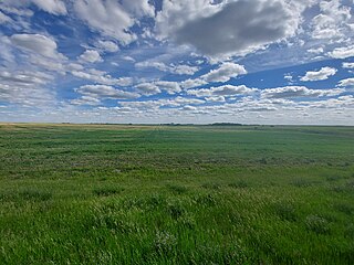
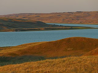
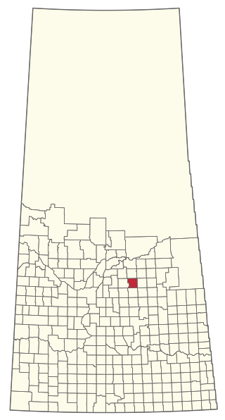
The Rural Municipality of Ituna Bon Accord No. 246 is a rural municipality (RM) in the Canadian province of Saskatchewan within Census Division No. 10 and SARM Division No. 4.

<span class="mw-page-title-main">Rural Municipality of Kinistino No. 459</span> Rural municipality in Saskatchewan, Canada

The Rural Municipality of Kinistino No. 459 is a rural municipality (RM) in the Canadian province of Saskatchewan within Census Division No. 15 and SARM Division No. 5.

<span class="mw-page-title-main">Rural Municipality of Lake Lenore No. 399</span> Rural municipality in Saskatchewan, Canada

The Rural Municipality of Lake Lenore No. 399 is a rural municipality (RM) in the Canadian province of Saskatchewan within Census Division No. 15 and SARM Division No. 5.

<span class="mw-page-title-main">Rural Municipality of Lakeview No. 337</span> Rural municipality in Saskatchewan, Canada

The Rural Municipality of Lakeview No. 337 is a rural municipality (RM) in the Canadian province of Saskatchewan within Census Division No. 10 and SARM Division No. 4.

<span class="mw-page-title-main">Rural Municipality of Preeceville No. 334</span> Rural municipality in Saskatchewan, Canada

The Rural Municipality of Preeceville No. 334 is a rural municipality (RM) in the Canadian province of Saskatchewan within Census Division No. 9 and SARM Division No. 4.

<span class="mw-page-title-main">Rural Municipality of St. Peter No. 369</span> Rural municipality in Saskatchewan, Canada

The Rural Municipality of St. Peter No. 369 is a rural municipality (RM) in the Canadian province of Saskatchewan within Census Division No. 15 and SARM Division No. 5.

<span class="mw-page-title-main">Rural Municipality of St. Philips No. 301</span> Rural municipality in Saskatchewan, Canada

The Rural Municipality of St. Philips No. 301 is a rural municipality (RM) in the Canadian province of Saskatchewan within Census Division No. 9 and SARM Division No. 4.

References

  1. "Pre-packaged CSV files - CGN, Canada/Province/Territory (cgn_sk_csv_eng.zip)". Government of Canada. July 24, 2019. Retrieved May 23, 2020.
  2. 1 2 "Rural Municipality Incorporations (Alphabetical)". Saskatchewan Ministry of Municipal Affairs. Archived from the original on April 21, 2011. Retrieved May 9, 2020.
  3. 1 2 3 4 "Municipality Details: RM of Coalfields No. 4". Government of Saskatchewan. Retrieved May 21, 2020.
  4. 1 2 3 "Population and dwelling counts, for Canada, provinces and territories, and census subdivisions (municipalities), 2016 and 2011 censuses – 100% data (Saskatchewan)". Statistics Canada. February 8, 2017. Retrieved May 1, 2020.
  5. "Saskatchewan Census Population" (PDF). Saskatchewan Bureau of Statistics. Archived from the original (PDF) on September 24, 2015. Retrieved May 9, 2020.
  6. "Saskatchewan Census Population". Saskatchewan Bureau of Statistics. Retrieved May 9, 2020.
  7. "Population and dwelling counts: Canada, provinces and territories, census divisions and census subdivisions (municipalities), Saskatchewan". Statistics Canada. February 9, 2022. Retrieved April 13, 2022.
  8. "Roche Percee Recreation Site". Canadian Geographical Names Database. Government of Canada. Retrieved December 28, 2023.
  9. "Roche Percee Campground". Tourism Saskatchewan. Government of Saskatcehwan. Retrieved December 28, 2023.

Commons-logo.svg Media related to Coalfields No. 4 at Wikimedia Commons