Rural Municipality of Souris Valley No. 7

Last updated

Souris Valley No. 7
Rural Municipality of Souris Valley No. 7
RM of Souris Valley.jpg
Oil field in the RM of Souris Valley
SK RM 7 Souris Valley.svg
Location of the RM of Souris Valley No. 7 in Saskatchewan
Coordinates: 49°08′10″N103°50′20″W / 49.136°N 103.839°W / 49.136; -103.839 Coordinates: 49°08′10″N103°50′20″W / 49.136°N 103.839°W / 49.136; -103.839 [1]
Country Canada
Province Saskatchewan
Census division 2
SARM division 1
Federal riding Souris--Moose Mountain
Provincial riding Estevan
Formed [2] December 13, 1909
Government
[3]
   Reeve Robert Forrester
  Governing bodyRM of Souris Valley No. 7 Council
  AdministratorErica Pederson
  Office location Oungre
Area
 (2016) [4]
  Land817.52 km2 (315.65 sq mi)
Population
 (2016) [4]
  Total249
  Density0.3/km2 (0.8/sq mi)
Time zone CST
  Summer (DST) CST
Postal code
S0C 1Z0
Area code(s) 306 and 639
Website Official website

The Rural Municipality of Souris Valley No. 7 (2016 population: 249) is a rural municipality (RM) in the Canadian province of Saskatchewan within Census Division No. 2 and SARM Division No. 1. Located in the southeast portion of the province, it is adjacent to the United States border, neighbouring Divide County in North Dakota.

Contents

History

The RM of Souris Valley No. 7 incorporated as a rural municipality on December 13, 1909. [2]

Geography

Communities and localities

The following urban municipalities are surrounded by the RM.

Villages [5]

The following unincorporated communities are within the RM.

Localities

Oungre Memorial Regional Park

Souris Valley Communiplex at Oungre Park Souris Valley Communiplex at Oungre Park.jpg
Souris Valley Communiplex at Oungre Park

Oungre Park ( 49°09′52″N103°48′32″W / 49.1644°N 103.8088°W / 49.1644; -103.8088 ) is a regional park in the RM that was founded in 1963 and has a campground, golf course, ball diamonds, disk golf, and a community centre. The park is located on the southern bank of Long Creek.

The original homesteader on the land, Frank Foster, had planted a grove of trees at the site in 1908. Even though the Fosters had left the area in 1926 after Frank's death, the site had become known as Foster's Grove and had become the location of annual sports days and picnics. In 1942, Foster's Grove was purchased by the RM. A bandstand was constructed in 1946 and a cenotaph was erected in 1947. In 1963, the park became Oungre Memorial Regional Park and further developments followed, such as the golf course in 1967, a swimming pool in 1969, the Souris Valley Communiplex in 1984, and an 18-hole mini golf course in 1985.

The Communiplex has an indoor swimming pool, arena, and restaurant. The golf course is a 9-hole, sand green course totalling 2,900 yards. [6] The campground have 29 full service sites as well as electric and tenting sites. There are modern washrooms, laundry facilities, showers, and potable water. [7] [8] [9]

Demographics

Population history
(1981–2016)
YearPop.±%
1981546    
1986525−3.8%
1991444−15.4%
1996 422−5.0%
2001 326−22.7%
2006 230−29.4%
2011 240+4.3%
2016 249+3.8%
Source: Statistics Canada via Saskatchewan Bureau of Statistics [10] [11]

In the 2021 Census of Population conducted by Statistics Canada, the RM of Souris Valley No. 7 had a population of 220 living in 94 of its 110 total private dwellings, a change of

In the 2016 Census of Population, the RM of Souris Valley No. 7 recorded a population of 249 living in 99 of its 128 total private dwellings, a

Government

The RM of Souris Valley No. 7 is governed by an elected municipal council and an appointed administrator that meets on the second Tuesday of every month. [3] The reeve of the RM is Robert Forrester while its administrator is Erica Pederson. [3] The RM's office is located in Oungre. [3]

See also

Related Research Articles

<span class="mw-page-title-main">Rural Municipality of Sherwood No. 159</span> Rural Municipality in Saskatchewan, Canada

The Rural Municipality of Sherwood No. 159 is a rural municipality (RM) in the Canadian province of Saskatchewan within Census Division No. 6 and SARM Division No. 2. In the south-central portion of the province, it surrounds the city of Regina, the provincial capital, and forms part of the Regina census metropolitan area.

<span class="mw-page-title-main">Rural Municipality of Milton No. 292</span> Rural Municipality in Saskatchewan, Canada

The Rural Municipality of Milton No. 292 is a rural municipality (RM) in the Canadian province of Saskatchewan within Census Division No. 13 and SARM Division No. 6. Located in the west-central portion of the province, it is adjacent to the Alberta boundary.

<span class="mw-page-title-main">Rural Municipality of Fillmore No. 96</span> Rural Municipality in Saskatchewan, Canada

The Rural Municipality of Fillmore No. 96 is a rural municipality (RM) in the Canadian province of Saskatchewan within Census Division No. 2 and SARM Division No. 1. It is located in the south-east portion of the province along Highway 33.

<span class="mw-page-title-main">Rural Municipality of Canwood No. 494</span> Rural Municipality in Saskatchewan, Canada

The Rural Municipality of Canwood No. 494 is a rural municipality (RM) in the Canadian province of Saskatchewan within Census Division No. 16 and SARM Division No. 5. The RM is located in the north-central portion of the province, west of the City of Prince Albert.

<span class="mw-page-title-main">Rural Municipality of Antler No. 61</span> Rural Municipality in Saskatchewan, Canada

The Rural Municipality of Antler No. 61 is a rural municipality (RM) in the Canadian province of Saskatchewan within Census Division No. 1 and SARM Division No. 1.

<span class="mw-page-title-main">Rural Municipality of Moosomin No. 121</span> Rural Municipality in Saskatchewan, Canada

The Rural Municipality of Moosomin No. 121 is a rural municipality (RM) in the Canadian province of Saskatchewan within Census Division No. 5 and SARM Division No. 1. It is located in the southeast portion of the province.

<span class="mw-page-title-main">Rural Municipality of Mayfield No. 406</span> Rural Municipality in Saskatchewan, Canada

The Rural Municipality of Mayfield No. 406 is a rural municipality (RM) in the Canadian province of Saskatchewan within Census Division No. 16 and SARM Division No. 6.

<span class="mw-page-title-main">Rural Municipality of Surprise Valley No. 9</span> Rural municipality in Saskatchewan, Canada

The Rural Municipality of Surprise Valley No. 9 is a rural municipality (RM) in the Canadian province of Saskatchewan within Census Division No. 2 and SARM Division No. 2. Located in the southeast portion of the province, it is adjacent to the United States border, neighbouring Sheridan County in Montana.

<span class="mw-page-title-main">Rural Municipality of Spy Hill No. 152</span> Rural Municipality in Saskatchewan, Canada

The Rural Municipality of Spy Hill No. 152 is a rural municipality (RM) in the Canadian province of Saskatchewan within Census Division No. 5 and SARM Division No. 1. It is located in the east-central portion of the province.

<span class="mw-page-title-main">Rural Municipality of Poplar Valley No. 12</span> Rural Municipality in Saskatchewan, Canada

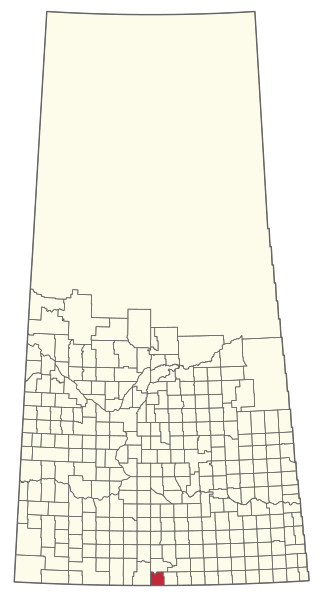
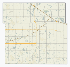
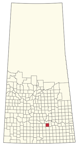
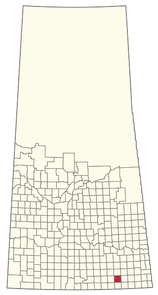
The Rural Municipality of Poplar Valley No. 12 is a rural municipality (RM) in the Canadian province of Saskatchewan within Census Division No. 3 and SARM Division No. 2. It is located in the southern portion of the province. It is adjacent to the United States border, neighbouring Daniels County in Montana.

<span class="mw-page-title-main">Rural Municipality of Cymri No. 36</span> Rural Municipality in Saskatchewan, Canada

The Rural Municipality of Cymri No. 36 is a rural municipality (RM) in the Canadian province of Saskatchewan within Census Division No. 2 and SARM Division No. 1. It is located in the southeast portion of the province.

<span class="mw-page-title-main">Rural Municipality of Laurier No. 38</span> Rural Municipality in Saskatchewan, Canada

The Rural Municipality of Laurier No. 38 is a rural municipality (RM) in the Canadian province of Saskatchewan within Census Division No. 2 and SARM Division No. 2. it is located in the southeast portion of the province.

<span class="mw-page-title-main">Rural Municipality of Willow Bunch No. 42</span> Rural municipality in Saskatchewan, Canada

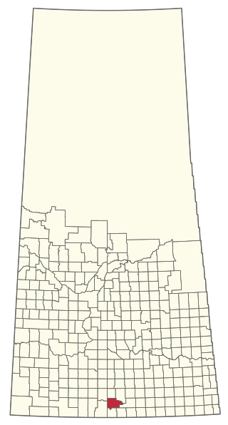
The Rural Municipality of Willow Bunch No. 42 is a rural municipality (RM) in the Canadian province of Saskatchewan within Census Division No. 3 and SARM Division No. 2. It is located in the south central portion of the province.

<span class="mw-page-title-main">Rural Municipality of Wawken No. 93</span> Rural municipality in Saskatchewan, Canada

The Rural Municipality of Wawken No. 93 is a rural municipality (RM) in the Canadian province of Saskatchewan within Census Division No. 1 and SARM Division No. 1. It is located in the southeast portion of the province.

<span class="mw-page-title-main">Rural Municipality of Biggar No. 347</span> Rural Municipality in Saskatchewan, Canada

The Rural Municipality of Biggar No. 347 is a rural municipality (RM) in the Canadian province of Saskatchewan within Census Division No. 12 and SARM Division No. 6.

<span class="mw-page-title-main">Rural Municipality of Snipe Lake No. 259</span> Rural Municipality in Saskatchewan, Canada

The Rural Municipality of Snipe Lake No. 259 is a rural municipality (RM) in the Canadian province of Saskatchewan within Census Division No. 8 and SARM Division No. 3.

<span class="mw-page-title-main">Rural Municipality of Riverside No. 168</span> Rural Municipality in Saskatchewan, Canada

The Rural Municipality of Riverside No. 168 is a rural municipality (RM) in the Canadian province of Saskatchewan within Census Division No. 8 and SARM Division No. 3.

<span class="mw-page-title-main">Rural Municipality of Ituna Bon Accord No. 246</span> Rural Municipality in Saskatchewan, Canada

The Rural Municipality of Ituna Bon Accord No. 246 is a rural municipality (RM) in the Canadian province of Saskatchewan within Census Division No. 10 and SARM Division No. 4.

<span class="mw-page-title-main">Rural Municipality of Last Mountain Valley No. 250</span> Rural Municipality in Saskatchewan, Canada

The Rural Municipality of Last Mountain Valley No. 250 is a rural municipality (RM) in the Canadian province of Saskatchewan within Census Division No. 11 and SARM Division No. 5.

<span class="mw-page-title-main">Rural Municipality of Montrose No. 315</span> Rural Municipality in Saskatchewan, Canada

The Rural Municipality of Montrose No. 315 is a rural municipality (RM) in the Canadian province of Saskatchewan within Census Division No. 12 and SARM Division No. 5.

References

  1. "Pre-packaged CSV files - CGN, Canada/Province/Territory (cgn_sk_csv_eng.zip)". Government of Canada. July 24, 2019. Retrieved May 23, 2020.
  2. 1 2 "Rural Municipality Incorporations (Alphabetical)". Saskatchewan Ministry of Municipal Affairs. Archived from the original on April 21, 2011. Retrieved May 9, 2020.
  3. 1 2 3 4 "Municipality Details: RM of Souris Valley No. 7". Government of Saskatchewan. Retrieved May 21, 2020.
  4. 1 2 3 "Population and dwelling counts, for Canada, provinces and territories, and census subdivisions (municipalities), 2016 and 2011 censuses – 100% data (Saskatchewan)". Statistics Canada. February 8, 2017. Retrieved May 1, 2020.
  5. SGS Sask Cemeteries by RM No.
  6. "Oungre Memorial Regional Park Golf Course". Golf link. LoveToKnow Corp. Retrieved October 30, 2022.
  7. "Oungre memorial". Sask Regional Parks. Saskatchewan Regional Parks. Retrieved October 30, 2022.
  8. "Oungre Memorial Regional Park". Oungre Park. Oungre Park. Retrieved October 30, 2022.
  9. "Oungre Memorial Regional Park". Tourism Saskatchewan. Government of Saskatchewan. Retrieved October 30, 2022.
  10. "Saskatchewan Census Population" (PDF). Saskatchewan Bureau of Statistics. Archived from the original (PDF) on September 24, 2015. Retrieved May 9, 2020.
  11. "Saskatchewan Census Population". Saskatchewan Bureau of Statistics. Retrieved May 9, 2020.
  12. "Population and dwelling counts: Canada, provinces and territories, census divisions and census subdivisions (municipalities), Saskatchewan". Statistics Canada. February 9, 2022. Retrieved April 13, 2022.