Related Research Articles

The United Nations Economic Commission for Europe (ECE) is one of the five regional commissions under the jurisdiction of the United Nations Economic and Social Council. It was established in order to promote economic cooperation and integrations among its Member States.

A metropolitan area, sometimes referred to as a metro area or commuter belt, is a region consisting of a densely populated urban core and its less-populated surrounding territories, sharing industry, infrastructure, and housing. A metro area usually comprises multiple jurisdictions and municipalities: neighborhoods, townships, boroughs, cities, towns, exurbs, suburbs, counties, districts, states, and even nations like the eurodistricts. As social, economic and political institutions have changed, metropolitan areas have become key economic and political regions. Metropolitan areas include one or more urban areas, as well as satellite cities, towns and intervening rural areas that are socioeconomically tied to the urban core, typically measured by commuting patterns. In the United States, the concept of the metropolitan statistical area has gained prominence.
The Office for National Statistics (ONS) is the executive office of the UK Statistics Authority, a non-ministerial department which reports directly to the UK Parliament.
The census geographic units of Canada are the administrative divisions defined and used by Canada's federal government statistics bureau Statistics Canada to conduct the country's five-yearly census. They exist on four levels: the top-level (first-level) divisions are Canada's provinces and territories; these are divided into second-level census divisions, which in turn are divided into third-level census subdivisions and fourth-level dissemination areas.

Eurostat is a Directorate-General of the European Commission located in Luxembourg. Its main responsibilities are to provide statistical information to the institutions of the European Union (EU) and to promote the harmonisation of statistical methods across its member states and candidates for accession as well as EFTA countries. The organisations in the different countries that cooperate with Eurostat are summarised under the concept of the European Statistical System.

The Ministry of Internal Affairs and Communications is a cabinet-level ministry in the Government of Japan. Its English name was Ministry of Public Management, Home Affairs, Posts and Telecommunications (MPHPT) prior to 2004. It is housed in the 2nd Building of the Central Common Government Office at 2-1-2 Kasumigaseki in Chiyoda, Tokyo, Japan.

Greater Glasgow is an urban settlement in Scotland consisting of all localities which are physically attached to the city of Glasgow, forming with it a single contiguous urban area. It does not relate to municipal government boundaries and its territorial extent is defined by the General Register Office for Scotland, which determines settlements in Scotland for census and statistical purposes. Greater Glasgow had a population of 1,199,629 at the time of the 2001 UK Census making it the largest urban area in Scotland and the fifth-largest in the United Kingdom.

There are six main administrative districts of Israel, known in Hebrew as mehozot and Arabic as mintaqah and fifteen sub-districts known as nafot. Each sub-district is further divided into cities, municipalities, and regional councils it contains.
Regional economics is a sub-discipline of economics and is often regarded as one of the fields of the social sciences. It addresses the economic aspect of the regional problems that are spatially analyzable so that theoretical or policy implications can be derived with respect to regions whose geographical scope ranges from local to global areas.

Cihanbeyli is a town and district of Konya Province in the Central Anatolia region of Turkey. According to 2000 census, population of the district is 75,871 of which 18,306 live in the town of Cihanbeyli.

The United Nations geoscheme is a system which divides the countries of the world into regional and subregional groups. It was devised by the United Nations Statistics Division (UNSD) based on the M49 coding classification.

The National Statistics Office (GeoStat) is an agency in charge of national statistics and responsible for carrying out population, agricultural and other censuses in Georgia. It was established as a legal entity of public law according to the December 11, 2009 law of Georgia, succeeding the Department of Statistics of the Ministry of Economy and Sustainable Development of Georgia. The head office is located in Tbilisi.
The Ministry of Statistics and Programme Implementation (MOSPI) is a ministry of Government of India. concerned with coverage and quality aspects of statistics released. The surveys conducted by the Ministry are based on scientific sampling methods. The current head of the ministry is DV Sadananda Gowda

The regions of England, formerly known as the government office regions, are the highest tier of sub-national division in England. Between 1994 and 2011, nine regions had officially devolved functions within government. While they no longer fulfill this role, they continue to be used for statistical and some administrative purposes. They define areas (constituencies) for the purposes of elections to the European Parliament. Eurostat also uses them to demarcate first level Nomenclature of Territorial Units for Statistics (NUTS) regions within the European Union. The regions generally follow the boundaries of the former standard regions, established in the 1940s for statistical purposes.

The State Statistics Committee of Azerbaijan Republic is a governmental agency within the Cabinet of Azerbaijan in charge of collection, processing and disseminating statistical data on the economy, demographics and other sectors of activity in Azerbaijan Republic. The agency is headed by Arif Valiyev.
Sub-national statistical services when autonomous are part of the overall statistical architecture of a country along with a central statistical organisation existing in nearly every country, and also various sectoral statistical services established in Ministerial departments or other government agencies. This is particularly true in the case of most Federation of states as shown in the table below. Those of these sub-national statistical services established in non-independent territories generally act as a central statistical organisation for the territory. The mandate of these autonomous services varies from country to country; their statistical production intends to respond mainly to local needs for statistics, complementary to the production of national statistical data.
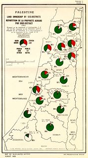
Village Statistics, 1945 was a joint survey work prepared by the Government Office of Statistics and the Department of Lands of the British Mandate Government for the Anglo-American Committee of Inquiry on Palestine which acted in early 1946. The data were calculated as of April 1, 1945, and was later published and also served the UNSCOP committee that operated in 1947.

The Hume is an economic rural region located in the north-eastern part of Victoria, Australia. Comprising an area in excess of 40,000 square kilometres (15,000 sq mi) with a population that ranges from 263,000 to 300,000, the Hume region includes the local government areas of Alpine Shire, Rural City of Benalla, City of Wodonga, City of Greater Shepparton, Shire of Indigo, Shire of Mansfield, Shire of Strathbogie, Shire of Towong and the Rural City of Wangaratta, and also includes five unincorporated areas encompassing the alpine ski resorts in the region.
References
| This statistics-related article is a stub. You can help Wikipedia by expanding it. |