
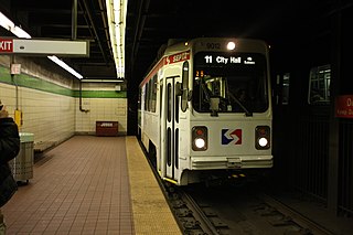
The Broad Street Line (BSL), also known as the Broad Street subway (BSS), Orange Line, or Broad Line, is a subway line owned by the city of Philadelphia and operated by the Southeastern Pennsylvania Transportation Authority (SEPTA). The line runs primarily north-south from the Fern Rock Transportation Center in North Philadelphia through Center City Philadelphia to NRG station at Pattison Avenue in South Philadelphia; the latter station provides access to the stadiums and arenas for the city's major professional sports teams at the South Philadelphia Sports Complex, about a quarter mile away. It is named for Broad Street, under which the line runs for almost its entire length. In 2024, as part of the SEPTA Metro plan, the Broad Street Line is expected to be renamed the B Line.

Transportation in Philadelphia involves the various modes of transport within the city and its required infrastructure. In addition to facilitating intracity travel, Philadelphia's transportation system connects Philadelphia to towns of its metropolitan area and surrounding areas within the Northeast megalopolis.

West Philadelphia, nicknamed West Philly, is a section of the city of Philadelphia. Although there are no officially defined boundaries, it is generally considered to reach from the western shore of the Schuylkill River, to City Avenue to the northwest, Cobbs Creek to the southwest, and the SEPTA Media/Wawa Line to the south. An alternate definition includes all city land west of the Schuylkill; this would also include Southwest Philadelphia and its neighborhoods. The eastern side of West Philadelphia is also known as University City.
Roosevelt Boulevard, officially named the Theodore Roosevelt Memorial Boulevard and often referred to, chiefly by local Philadelphians, simply as "the Boulevard," is a major traffic artery through North and Northeast Philadelphia. The road begins at Interstate 76 in Fairmount Park, running as a freeway also known as the Roosevelt Boulevard Extension or the Roosevelt Expressway through North Philadelphia, then transitioning into a twelve-lane divided highway that forms the spine of Northeast Philadelphia to its end at the city line.
The SEPTA subway–surface trolley lines are a collection of five SEPTA trolley lines that operate on street-level tracks in West Philadelphia and Delaware County, Pennsylvania, and also underneath Market Street in Philadelphia's Center City. The lines, Routes 10, 11, 13, 34, and 36, collectively operate on about 39.6 miles (63.7 km) of route.

The Schuylkill Expressway, locally known as "the Schuylkill", is a freeway through southern Montgomery County and Philadelphia. It is the easternmost segment of Interstate 76 (I-76) in the U.S. state of Pennsylvania. It extends from the Valley Forge interchange of the Pennsylvania Turnpike in King of Prussia, paralleling its namesake Schuylkill River for most of the route, southeast to the Walt Whitman Bridge over the Delaware River in South Philadelphia. It serves as the primary corridor into Philadelphia from points west. Maintenance and planning for most of the highway are administered through Pennsylvania Department of Transportation (PennDOT) District 6, with the Delaware River Port Authority (DRPA) maintaining the approach to the Walt Whitman Bridge.
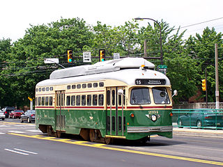
Route 15, the Girard Avenue Line, is a trolley line operated by the Southeastern Pennsylvania Transportation Authority (SEPTA) along Girard Avenue through North and West Philadelphia, Pennsylvania, United States. As of 2007, it is the only surface trolley line in the City Transit Division that is not part of the Subway–Surface Trolley Lines. SEPTA PCC II vehicles are used on the line.

The Centennial District is a 700-acre section of West Philadelphia, Pennsylvania, United States that contains the Philadelphia Zoo, the Please Touch Museum and the Mann Music Center. The neighborhood sits on a section of town that was the location of the 1876 Centennial Exposition, which was 100 years after the founding of the United States with the signing of the Declaration of Independence.

Route 11, also known as the Woodland Avenue Line, is a trolley line operated by the Southeastern Pennsylvania Transportation Authority (SEPTA) that connects the 13th Street station in downtown Philadelphia, Pennsylvania, to Darby Transportation Center in Darby, Pennsylvania. It is one of five lines that are part of the subway–surface trolley system. Sitting at an average of 13,580 riders per weekday in 2019, it is the most used subway-surface trolley route, even though it lacks overnight service. From 2024 onwards, this route will be referred as T4 Woodland Avenue Line.

SEPTA Route 10, also known as the Lancaster Avenue Line, to be known as T1 Lancaster Avenue Line, is a trolley line operated by the Southeastern Pennsylvania Transportation Authority (SEPTA) that connects the 13th Street station in Center City Philadelphia, Pennsylvania, to the 63rd Street–Malvern Avenue station in the Overbrook section of West Philadelphia. It is one out of five lines that is part of the SEPTA's subway–surface trolley system and is 11.6 mi (18.7 km) long. It is the least used subway-surface trolley line, but unlike Route 11, the most used subway-surface trolley line, it has overnight service.
19th Street station is an underground trolley station in Philadelphia. It is located underneath Market Street in Center City Philadelphia, and serves all routes of the SEPTA subway–surface trolley lines. The station was opened by the Philadelphia Transportation Company in 1907.

Pennsylvania Route 3 is a 24.3-mile (39.1 km) state highway located in the southeastern portion of Pennsylvania. The route runs from U.S. Route 322 Business in West Chester east to PA 611 in Philadelphia.
The City Transit Division of the Southeastern Pennsylvania Transportation Authority (SEPTA) operate almost all of Philadelphia's public transit, including all six trolley, three trackless trolley, and 70 bus lines within city limits. Some of the bordering municipalities are served by the City Transit division, despite not being part of the city. For example, Cheltenham Township has 13 city division routes and no Suburban Division ones. The City Transit division also operates the 400 Series routes which are designed to serve students attending schools in the city of Philadelphia.

Spring Garden is a neighborhood in central Philadelphia, Pennsylvania, bordering Center City on the north. Spring Garden is a neighborhood that combines diverse residential neighborhoods and significant cultural attractions.

U.S. Route 13 (US 13) is a United States Numbered Highway running from Fayetteville, North Carolina, north to Morrisville, Pennsylvania. The route runs for 49.359 miles (79.436 km) through the Delaware Valley in the U.S. state of Pennsylvania. The route enters the state from Delaware in Marcus Hook, Delaware County. It continues northeast through Delaware County, passing through the city of Chester before heading through suburban areas along Chester Pike to Darby. US 13 enters the city of Philadelphia on Baltimore Avenue and runs through West Philadelphia to University City, where it turns north along several city streets before heading east across the Schuylkill River along Girard Avenue. The route turns north and heads to North Philadelphia, where it runs northeast along Hunting Park Avenue. US 13 becomes concurrent with US 1 on Roosevelt Boulevard, continuing into Northeast Philadelphia. US 13 splits southeast on a one-way pair of streets before heading northeast out of the city on Frankford Avenue. The route continues into Bucks County as Bristol Pike, heading northeast to Bristol, where it turns into a divided highway. US 13 becomes a freeway in Tullytown and continues north to its terminus at US 1 in Falls Township, near Morrisville. US 13 roughly parallels Interstate 95 (I-95) through its course in Pennsylvania.
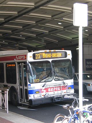
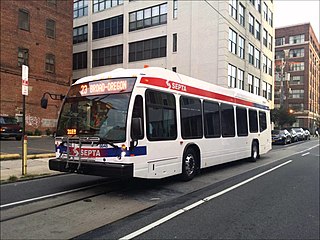
SEPTA Trolley Route 23 is a former streetcar line now operated with buses. It is operated by the Southeastern Pennsylvania Transportation Authority (SEPTA) in Philadelphia, Pennsylvania, United States. The line runs between the Chestnut Hill and Center City neighborhoods via Germantown Avenue, 11th, and 12th Streets.
Callowhill Depot is a bus and trolley barn operated by the Southeastern Pennsylvania Transportation Authority (SEPTA), located in West Philadelphia, near the Delaware County border. It was built in 1913 by the Philadelphia Rapid Transit Company (PRT) and was later operated by the Philadelphia Transportation Company (PTC) before being taken over by SEPTA. The depot was constructed as part of the Thomas E. Mitten modernization program. Since its construction, the depot has suffered fire damage and reconstruction in 1949, 1950, and 1995.

Girard Avenue is a major commercial and residential street in Philadelphia. For most of its length it runs east–west, but at Frankford Avenue it makes a 135-degree turn north. Parts of the road are signed as U.S. Route 13 and U.S. Route 30.
Route 35 is a bus route operated by the SEPTA in Philadelphia, Pennsylvania, United States.
