
Kruger National Park is one of the largest game reserves in Africa. It covers an area of 19,485 square kilometres (7,523 sq mi) in the provinces of Limpopo and Mpumalanga in northeastern South Africa, and extends 360 kilometres (220 mi) from north to south and 65 kilometres (40 mi) from east to west. The administrative headquarters are in Skukuza. Areas of the park were first protected by the government of the South African Republic in 1898, and it became South Africa's first national park in 1926.

Hazyview is a lush, green sub-tropical farming town in Mpumalanga, South Africa and is renowned for its large banana and macadamia nuts industries, contributing about 20% of South Africa's bananas and 30% of macadamia output. Bordering the Kruger National Park, the town's name is derived from the shimmering haze that occurs during the heat of summer. Most of the province of Mpumalanga's private game reserves are found just east of Hazyview.

Skukuza, located 50 km east of Hazyview at the confluence of the N'waswitshaka and Sabie Rivers in Mpumalanga, is the administrative headquarters and main camp of the Kruger National Park, South Africa. It is also the largest rest camp of the park and the country. It is South Africa's number one game viewing destination and in the most popular game reserve in the country. It is popular with domestic and foreign tourists alike, as the big five game are in relative abundance when compared it to other game reserves in the country. A tourist in Skukuza may not have to go out looking for Africa's big five, as these animals could potentially be observed from the deck of the Jackalberry restaurant. Lions, leopards and cheetahs regularly kill their prey on the green lawns of Skukuza's golf course or cricket club. The game reserve is situated in a medium rainfall area, on the well-wooded banks of the Sabie and N'waswitshaka rivers of Mpumalanga Province.

Lion Sands Private Game Reserve, also known as Lion Sands Reserve, was established in 1933 by Guy Aubrey Chalkley, and forms part of the Sabi Sands Private Game Reserve as well as the Kruger National Park, which together with some other parks make up the Greater Kruger National Park in South Africa.

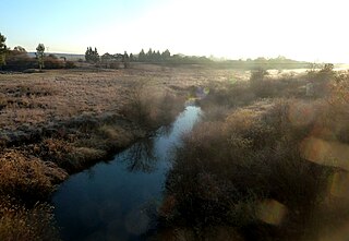
Ulusaba Private Game Reserve, owned by Sir Richard Branson as part of the Virgin Limited Edition luxury property portfolio, consists of about 13,500 ha of land set in the heart of the Sabi Sand Private Game Reserve. This private game reserve borders on the sprawling Kruger National Park in South Africa's Mpumalanga province and is home to an abundance of wildlife. Ulusaba means fearful in the local Tsonga Shangaan language and it was a name given to the Sabie River by the Shangaan people. The Sabie River was originally called Ulusaba by the Shangaan simply because there was once a large concentration of dangerous Nile crocodile in the river, hence Ulusaba. Before the establishment of the Kruger National Park, Ulusaba was once a home of Tsonga Shangaan people, the Shangaan were evicted from this land when the Kruger National Park was established and were relocated in nearby villages adjacent Ulusaba Private Game Reserve.
Inkomati WMA, or Inkomati Water Management Area , in South Africa is situated in the north-eastern part of South Africa in the Mpumalanga Province, with a small area in the Limpopo Province. It borders on Mozambique in the east and on Swaziland in the south-east. The water management area extends over several parallel river catchments which all drain in a general easterly direction, and flow together at the border with Mozambique or within Mozambique, to form the Incomati River which discharges into the Indian Ocean immediately north of Maputo. A special situation is presented by the Komati River, the most southern tributary of the Incomati River, which rises in South Africa and flows into Swaziland, then re-enters South Africa where it is joined by the Crocodile River at the border with Mozambique, before flowing into Mozambique as the Incomati River. The Sabie River is the other main river in the water management area and flows into Corumuna Dam in Mozambique just downstream of the border with South Africa, and upstream of its confluence with the Inkomati River.

The Bronkhostspruit,, is a river in Gauteng, province South Africa. It is a tributary of the Wilge River, Olifants River basin that gives its name to Bronkhorstspruit town.
The Wilge River is a river in Mpumalanga and Gauteng provinces, South Africa. It is a tributary of the Olifants River.
Witklip Dam is a gravity and arch type dam located on the Sand River near Sabie, Mpumalanga, South Africa. It was established in 1969 and serves primarily for irrigation purposes. The hazard potential of the dam has been ranked high (3).

The Elands River is a river in the former Transvaal area, South Africa. It is a tributary of the Olifants River, part of the Limpopo River basin.
Alexandria is a town in Bushbuckridge Local Municipality under Ehlanzeni District Municipality in the Mpumalanga province of South Africa. Its got its theme of footprints on rock in the mountains of Simeleni. It borders two rivers Bhejane and Ngwenyameni that connect with the giant Sabie River. It is the birthplace of well known businessman Solly Ndlovu and also the birthplace of the South African drone sketch drawing and electrician ( ).
The R537 is a Regional Route in South Africa. Its northern terminus is the R536 just east of Sabie, Mpumalanga. It runs south-east, ending at an intersection with the R40 near White River.

Sabi Sand Game Reserve is located adjacent to the Kruger National Park in the Lowveld of Mpumalanga, South Africa. Officially named Sabi Sand Wildtuin, the Sabi Sand Game Reserve consists of a group of private game reserves. The Newington Gate is at 24°52′9″S 31°24′16″E and west of the Kruger Gate and Skukuza camp of Kruger Park. Other entrances are Gowrie Gate in the far north and Shaws Gate in the south.
Simile is the Black township on the northern side of the forestry town Sabie. It falls under the Thaba Chweu Local Municipality of Mpumalanga province, South Africa.
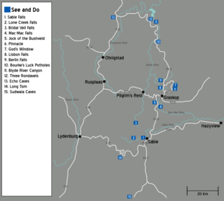
The Panorama Route is a scenic road in South Africa connecting several cultural and natural points of interest. This route, steeped in the history of South Africa, is situated in the Mpumalanga province. The route is centred around the Blyde River Canyon, the world’s third largest canyon, and features numerous waterfalls, one of the largest afforested areas in South Africa, and several natural landmarks. The route starts at the foot of the Long Tom Pass just outside Lydenburg, following the natural descent from the Great Escarpment to the Lowveld, and ending at the border of the Mpumalanga and Limpopo provinces near the Echo Caves.

Canoeing South Africa is the governing body for the sport of canoeing and kayaking in South Africa.The body is affiliated to the International Canoe Federation (ICF) and the African Canoe Confederation.


