
The United States Census Bureau (USCB), officially the Bureau of the Census, is a principal agency of the U.S. Federal Statistical System, responsible for producing data about the American people and economy. The Census Bureau is part of the U.S. Department of Commerce and its director is appointed by the President of the United States.

The United States had an official estimated resident population of 331,893,745 on July 1, 2021, according to the U.S. Census Bureau. This figure includes the 50 states and the District of Columbia but excludes the population of five unincorporated U.S. territories as well as several minor island possessions. The United States is the third most populous country in the world. The Census Bureau showed a population increase of 0.12% for the twelve-month period ending in July 2021, below the world average annual rate of 0.9%. The total fertility rate in the United States estimated for 2021 is 1.664 children per woman, which is below the replacement fertility rate of approximately 2.1.
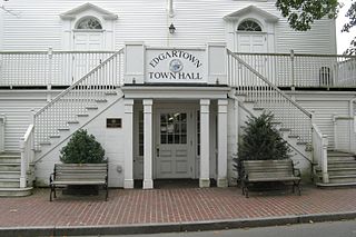
Dukes County is a county located in the U.S. state of Massachusetts. As of the 2020 census, the population was 20,600, making it the second-least populous county in Massachusetts. Its county seat is Edgartown.

Suffolk County is located in the Commonwealth of Massachusetts, in the United States. As of the 2020 census, the population was 797,936, making it the fourth-most populous county in Massachusetts. The county comprises the cities of Boston, Chelsea, Revere, and Winthrop. The traditional county seat is Boston, the state capital and the largest city in Massachusetts. The county government was abolished in 1999, and so Suffolk County today functions only as an administrative subdivision of state government and a set of communities grouped together for some statistical purposes. Suffolk County is located at the core of the Boston-Cambridge-Newton, MA-NH Metropolitan Statistical Area as well as the greater Boston-Worcester-Providence, MA-RI-NH-CT Combined Statistical Area.

Bethel Census Area is a census area in the U.S. state of Alaska. As of the 2020 census, the population is 18,666, up from 17,013 in 2010. It is part of the unorganized borough and therefore has no borough seat. Its largest community is the city of Bethel, which is also the largest city in the unorganized borough.

Smyth County is a county located in the U.S. state of Virginia. As of the 2020 census, the population was 29,800. Its county seat is Marion.

Harney County is one of the 36 counties in the U.S. state of Oregon. As of the 2020 census, the population was 7,495, making it the sixth-least populous county in Oregon. The county seat is Burns. Established in 1889, the county is named in honor of William S. Harney, a military officer of the period, who was involved in the Pig War and popular in the Pacific Northwest.

Kay County is a county located in the U.S. state of Oklahoma. As of the 2020 census, its population was 43,700. Its county seat is Newkirk, and the largest city is Ponca City.

Pasquotank County is a county located in the U.S. state of North Carolina. As of the 2020 Census, the population was 40,568. Its county seat is Elizabeth City. The county was originally created as Pasquotank Precinct and gained county status in 1739. Pasquotank County is part of the Elizabeth City, NC Micropolitan Statistical Area, which is also included in the Virginia Beach-Norfolk, VA-NC Combined Statistical Area.

Grant County is a county located in the U.S. state of New Mexico. At the 2020 census, the population was 28,185. Its county seat is Silver City. The county was founded in 1868 and named for Ulysses S. Grant, the 18th President of the United States.

Liberty County is a county located in the U.S. state of Montana. As of the 2020 census, the population was 1,959. Its county seat is Chester. The decision to separate the future Liberty County area from the previous Hill and Chouteau counties was carried in a 1919 vote; the organization was authorized to commence in the following February.

Caldwell is a city in and the county seat of Canyon County, Idaho. The population was 59,996 at the time of the 2020 United States census.

McGuire AFB/McGuire, the common name of the McGuire unit of Joint Base McGuire-Dix-Lakehurst, is a United States Air Force base in Burlington County, New Jersey, United States, approximately 16.1 miles (25.9 km) south-southeast of Trenton. McGuire is under the jurisdiction of the Air Mobility Command. It was consolidated with two adjoining US Army and Navy facilities to become part of Joint Base McGuire-Dix-Lakehurst on 1 October 2009.

Anderson Mill is a neighborhood of Austin and a former census-designated place (CDP) in Travis and Williamson counties in the U.S. state of Texas. The population was 7,199 at the 2010 census.
Race and ethnicity in the United States census, defined by the federal Office of Management and Budget (OMB) and the United States Census Bureau, are the self-identified categories of race or races and ethnicity chosen by residents, with which they most closely identify, and indicate whether they are of Hispanic or Latino origin.

Notre Dame is a census-designated place and unincorporated community north of the city of South Bend in St. Joseph County, in the U.S. state of Indiana. It includes the campuses of three colleges: the University of Notre Dame, Saint Mary's College, and Holy Cross College. Notre Dame is split between Clay and Portage Townships. As of the 2020 census, its population was 7,234.

Americans are the citizens and nationals of the United States of America. Although direct citizens and nationals make up the majority of Americans, many dual citizens, expatriates, and permanent residents could also legally claim American nationality. The United States is home to people of many racial and ethnic origins; consequently, American culture and law do not equate nationality with race or ethnicity, but with citizenship and an oath of permanent allegiance.
The United States census of 2020 was the twenty-fourth decennial United States census. Census Day, the reference day used for the census, was April 1, 2020. Other than a pilot study during the 2000 census, this was the first U.S. census to offer options to respond online or by phone, in addition to the paper response form used for previous censuses. The census was taken during the COVID-19 pandemic, which affected its administration. The census recorded a resident population of 331,449,281 in the fifty states and the District of Columbia, an increase of 7.4 percent, or 22,703,743, over the preceding decade. The growth rate was the second-lowest ever recorded, and the net increase was the sixth highest in history. This was the first census where the ten most populous states each surpassed 10 million residents as well as the first census where the ten most populous cities each surpassed 1 million residents.


