Saline County, Nebraska

Last updated

Saline County
County of Saline
Saline County, Nebraska courthouse from NE.JPG
Saline County, Nebraska
Interactive map of Saline County
Map of Nebraska highlighting Saline County.svg
Location within the U.S. state of Nebraska
CountryFlag of the United States.svg  United States
State Flag of Nebraska.svg  Nebraska
EstablishedMarch 16, 1855
OrganizedFebruary 18, 1867
County seat Wilber
Largest city Crete
Area
  Total576 sq mi (1,490 km2)
  Land574 sq mi (1,490 km2)
  Water2.3 sq mi (6 km2)
Population
 (2020)
  Total14,292
  Density25/sq mi (9.6/km2)
Time zone UTC−6 (Central)
  Summer (DST) UTC−5 (CDT)
Area code 402/531
FIPS code31151
GNIS feature ID 835897
Website www.co.saline.ne.us

Saline County is a county in the U.S. state of Nebraska. As of the 2020 United States Census, the population was 14,292. [1] Its county seat is Wilber. [2]

Contents

In the Nebraska license plate system, Saline County is represented by the prefix 22 (it had the twenty-second-largest number of vehicles registered in the state when the license plate system was established in 1922).

History

Saline County was formed in 1855 and organized in 1867. [3] [4] The first permanent settler arrived in 1858. [5]

Geography

The terrain of Saline County is composed of low rolling hills, sloping to the east-southeast. [6] Most of the county's area is devoted to agriculture. The Big Blue River flows southward in the eastern part of the county. The middle and southern parts of the county are drained by Swan Creek and Turkey Creek, which combine and discharge into Big Blue River at the county's east boundary line close to its SE corner. [7] The county has an area of 576 square miles (1,490 km2), of which 574 square miles (1,490 km2) is land and 2.3 square miles (6.0 km2) (0.4%) is water. [8]

Major highways

Adjacent counties

Protected areas

Demographics

Historical population
CensusPop.Note
1860 39
1870 3,1067,864.1%
1880 14,491366.5%
1890 20,09738.7%
1900 18,252−9.2%
1910 17,866−2.1%
1920 16,514−7.6%
1930 16,5360.1%
1940 15,010−9.2%
1950 14,046−6.4%
1960 12,542−10.7%
1970 12,8092.1%
1980 13,1312.5%
1990 12,715−3.2%
2000 13,8438.9%
2010 14,2002.6%
2020 14,2920.6%
US Decennial Census [10]
1790-1960 [11] 1900-1990 [12]
1990-2000 [13] 2010 [14]

As of the 2000 United States Census, [15] there were 13,843 people, 5,188 households, and 3,507 families in the county. The population density was 24 people per square mile (9.3 people/km2). There were 5,611 housing units at an average density of 10 units per square mile (3.9 units/km2). The racial makeup of the county was 92.99% White, 0.36% Black or African American, 0.38% Native American, 1.70% Asian, 0.03% Pacific Islander, 3.40% from other races, and 1.15% from two or more races. 6.58% of the population were Hispanic or Latino of any race.

There were 5,188 households, out of which 32.80% had children under the age of 18 living with them, 56.50% were married couples living together, 7.20% had a female householder with no husband present, and 32.40% were non-families. 27.50% of all households were made up of individuals, and 14.30% had someone living alone who was 65 years of age or older. The average household size was 2.50 and the average family size was 3.04.

The county population contained 25.10% under the age of 18, 12.30% from 18 to 24, 25.00% from 25 to 44, 20.30% from 45 to 64, and 17.20% who were 65 years of age or older. The median age was 36 years. For every 100 females there were 97.80 males. For every 100 females age 18 and over, there were 95.10 males.

The median income for a household in the county was $35,914, and the median income for a family was $44,199. Males had a median income of $30,467 versus $22,690 for females. The per capita income for the county was $16,287. About 6.40% of families and 9.40% of the population were below the poverty line, including 8.90% of those under age 18 and 9.00% of those age 65 or over.

Communities

Cities

Villages

Unincorporated communities

Politics

United States presidential election results for Saline County, Nebraska [16]
Year Republican Democratic Third party
No.%No.%No.%
2020 3,63162.82%1,98634.36%1632.82%
2016 3,00458.49%1,73333.74%3997.77%
2012 2,55751.57%2,28946.17%1122.26%
2008 2,43446.35%2,67450.92%1432.72%
2004 3,07155.17%2,42043.48%751.35%
2000 2,58150.17%2,32145.11%2434.72%
1996 1,94537.58%2,52348.75%70713.66%
1992 1,74030.18%2,42542.06%1,60027.75%
1988 2,35542.75%3,12556.73%290.53%
1984 2,94254.54%2,38544.22%671.24%
1980 2,93454.17%1,90835.23%57410.60%
1976 2,33041.15%3,20556.61%1272.24%
1972 2,82851.59%2,65448.41%00.00%
1968 2,34144.73%2,54348.59%3506.69%
1964 1,78030.14%4,12569.86%00.00%
1960 2,88144.99%3,52355.01%00.00%
1956 3,24848.89%3,39551.11%00.00%
1952 4,22160.19%2,79239.81%00.00%
1948 2,64142.33%3,59857.67%00.00%
1944 3,25545.50%3,89954.50%00.00%
1940 3,67346.48%4,22953.52%00.00%
1936 2,63732.14%5,48066.78%891.08%
1932 1,99325.24%5,83173.85%720.91%
1928 3,34745.67%3,95553.97%260.35%
1924 2,83443.10%3,12347.49%6199.41%
1920 3,19758.67%2,17239.86%801.47%
1916 1,46935.10%2,64663.23%701.67%
1912 1,18529.74%1,94248.73%85821.53%
1908 2,04846.48%2,24951.04%1092.47%
1904 2,39061.38%1,10828.45%39610.17%
1900 2,23851.31%2,01846.26%1062.43%

See also

Related Research Articles

<span class="mw-page-title-main">York County, Nebraska</span> County in Nebraska, United States

York County is a county in the U.S. state of Nebraska. As of the 2020 United States Census, the population was 14,125. Its county seat is York.

<span class="mw-page-title-main">Webster County, Nebraska</span> County in Nebraska, United States

Webster County is a county in the U.S. state of Nebraska. As of the 2020 United States Census, the population was 3,411. Its county seat is Red Cloud. The county was formed in 1871, and was named for Daniel Webster.

<span class="mw-page-title-main">Thayer County, Nebraska</span> County in Nebraska, United States

Thayer County is a county in the U.S. state of Nebraska. As of the 2020 United States Census, the population was 5,034. Its county seat is Hebron. The county was created in 1856 and originally named Jefferson County. It was organized in 1870-1871 and renamed for General and Governor John Milton Thayer.

<span class="mw-page-title-main">Seward County, Nebraska</span> County in Nebraska, United States

Seward County is a county in the U.S. state of Nebraska, United States. As of the 2020 United States Census, the population was 17,609. Its county seat is Seward. The county was formed in 1855, and was organized in 1867. It was originally called Greene County, and in 1862 it was renamed for William H. Seward, Secretary of State under Abraham Lincoln and Andrew Johnson. Seward County is part of the Lincoln, NE Metropolitan Statistical Area.

<span class="mw-page-title-main">Rock County, Nebraska</span> County in Nebraska, United States

Rock County is a county in the U.S. state of Nebraska. As of the 2020 United States Census, the population was 1,262. Its county seat is Bassett.

<span class="mw-page-title-main">Pierce County, Nebraska</span> County in Nebraska, United States

Pierce County is a county in the U.S. state of Nebraska. As of the 2020 United States Census, the population was 7,317. Its county seat is Pierce. The county was formed in 1859, and was named for US President Franklin Pierce.

<span class="mw-page-title-main">Madison County, Nebraska</span> County in Nebraska, United States

Madison County is a county in the U.S. state of Nebraska. As of the 2020 United States Census, the population was 35,585. Its county seat is Madison and its largest city is Norfolk. Madison County was likely named for Madison, Wisconsin, which is where many of the county’s residents came from; the city was named for James Madison, fourth President of the United States.

<span class="mw-page-title-main">Johnson County, Nebraska</span> County in Nebraska, United States

Johnson County is a county in the U.S. state of Nebraska. As of the 2020 United States Census, the population was 5,290. Its county seat is Tecumseh. The county was formed in 1855, and was organized in 1857. It was named after Richard Mentor Johnson, who was Vice President of the United States from 1837 to 1841.

<span class="mw-page-title-main">Jefferson County, Nebraska</span> County in Nebraska, United States

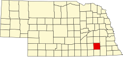
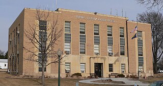
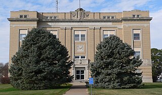
Jefferson County is a county in the U.S. state of Nebraska. As of the 2020 United States Census, the population was 7,240. Its county seat is Fairbury. The county was named for Thomas Jefferson, third President of the United States of America.

<span class="mw-page-title-main">Howard County, Nebraska</span> County in Nebraska, United States

Howard County is a county in the state of Nebraska. As of the 2020 United States Census, the population was 6,475. Its county seat is St. Paul. The county was formed in 1871 and named after Civil War General Oliver Otis Howard.

<span class="mw-page-title-main">Garfield County, Nebraska</span> County in Nebraska, United States

Garfield County is a county in the U.S. state of Nebraska. As of the 2020 United States Census, the population was 1,813. Its county seat is Burwell. The county was organized in 1884; it was named for James A. Garfield, 20th President of the United States.

<span class="mw-page-title-main">Gage County, Nebraska</span> County in Nebraska, United States

Gage County is a county in the U.S. state of Nebraska. As of the 2020 United States Census, the population was 21,704. Its county seat is Beatrice. The county was created in 1855 and organized in 1857. It was formed from land taken from the Otoe in an 1854 treaty. The county was named for William D. Gage, a Methodist minister who served as the first chaplain of the Nebraska Territorial Legislature.

<span class="mw-page-title-main">Furnas County, Nebraska</span> County in Nebraska, United States

Furnas County is a county in the U.S. state of Nebraska. As of the 2020 United States Census, the population was 4,636. Its county seat is Beaver City. The county was named for Robert Wilkinson Furnas, the second governor of the state of Nebraska.

<span class="mw-page-title-main">Franklin County, Nebraska</span> County in Nebraska, United States

Franklin County is a county in the U.S. state of Nebraska. As of the 2020 census, the population was 2,889. Its county seat is Franklin. The county was formed in 1867 and organized in 1871. It was named for Benjamin Franklin.

<span class="mw-page-title-main">Cedar County, Nebraska</span> County in Nebraska, United States

Cedar County is a county in the U.S. state of Nebraska. As of the 2020 United States Census, the population was 8,380. The county seat is Hartington. The county was formed in 1857, and was named for the Cedar tree groves in the area.

<span class="mw-page-title-main">Burt County, Nebraska</span> County in Nebraska, United States

Burt County is a county in the U.S. state of Nebraska, bordering the west bank of the upper Missouri River. As of the 2020 United States Census, the population was 6,722. Its county seat is Tekamah. The county was formed in 1854 and named after Francis Burt, the first governor of Nebraska Territory.

<span class="mw-page-title-main">Lake County, Montana</span> County in Montana, United States

Lake County is a county located in the northwest part of the U.S. state of Montana. As of the 2020 census, the population was 31,134. Its county seat is Polson.

<span class="mw-page-title-main">Sedgwick County, Colorado</span> County in Colorado, United States

Sedgwick County is a county located in the U.S. state of Colorado. As of the 2020 census, the population was 2,404. The county seat is Julesburg. The county was named for Fort Sedgwick, a military post along the Platte Trail, which was named for General John Sedgwick. It is located near the state border with Nebraska.

<span class="mw-page-title-main">Swanton, Nebraska</span> Village in Saline County, Nebraska, united States

Swanton is a village in Saline County, Nebraska, United States. The population was 75 at the 2020 census.

<span class="mw-page-title-main">Wilber, Nebraska</span> City in Saline County, Nebraska, United States

Wilber is a city in and the county seat of Saline County, Nebraska, United States. The population was 1,855 at the 2010 census. It is the county seat of Saline County. Wilber is the official "Czech Capital of the USA" and hosts an annual Czech festival in August. Wilber's school is the Wilber-Clatonia High School.

References

  1. "Saline County, Nebraska". United States Census Bureau . Retrieved June 24, 2023.
  2. "Find a County". National Association of Counties. Retrieved June 7, 2011.
  3. Fitzpatrick, Lilian Linder (1925). Nebraska Place-Names. Lincoln: University of Nebraska Studies in Language, Literature, and Criticism. p. 122. Retrieved December 17, 2014.
  4. "Saline County". Nebraska Association of County Officials. Retrieved December 17, 2014.
  5. Burr, George L. (1921). History of Hamilton and Clay Counties, Nebraska, Vol. 1. S.J. Clarke Publishing Co. p. 135.
  6. "Find an Altitude" Google Maps (accessed 28 January 2019)
  7. Saline County NE Google Maps (accessed 28 January 2019)
  8. "2010 Census Gazetteer Files". US Census Bureau. August 22, 2012. Archived from the original on November 13, 2013. Retrieved December 11, 2014.
  9. Willard Meyer Natural Resource District-Swan Lake Google Maps (accessed 28 January 2019)
  10. "US Decennial Census". US Census Bureau. Retrieved December 11, 2014.
  11. "Historical Census Browser". University of Virginia Library. Retrieved December 11, 2014.
  12. "Population of Counties by Decennial Census: 1900 to 1990". US Census Bureau. Retrieved December 11, 2014.
  13. "Census 2000 PHC-T-4. Ranking Tables for Counties: 1990 and 2000" (PDF). US Census Bureau. Archived (PDF) from the original on March 27, 2010. Retrieved December 11, 2014.
  14. "State & County QuickFacts". United States Census Bureau . Retrieved September 22, 2013.
  15. "U.S. Census website". US Census Bureau. Retrieved January 31, 2008.
  16. Election Results

40°32′N97°08′W / 40.53°N 97.14°W / 40.53; -97.14