
Goslar is a district in Lower Saxony, Germany. It is bounded by the districts of Göttingen, Northeim, Hildesheim and Wolfenbüttel, the city of Salzgitter, and by the states of Saxony-Anhalt and Thuringia (Nordhausen).
Dufferin No. 190 is a rural municipality in south-central Saskatchewan, Canada. It is located in Division 2.
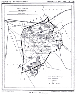
Zesgehuchten was a municipality in the Dutch province of North Brabant. It existed until 1921, when it became part of Geldrop.

Dziewiętlin is a village in the administrative district of Gmina Krośnice, within Milicz County, Lower Silesian Voivodeship, in south-western Poland. Prior to 1945 it was in Germany.
Domanice is a village in the administrative district of Gmina Wińsko, within Wołów County, Lower Silesian Voivodeship, in south-western Poland. Prior to 1945 it was in Germany.
Iwno is a village in the administrative district of Gmina Wińsko, within Wołów County, Lower Silesian Voivodeship, in south-western Poland. Prior to 1945 it was in Germany.

Samoklęski Duże is a village in the administrative district of Gmina Szubin, within Nakło County, Kuyavian-Pomeranian Voivodeship, in north-central Poland. It lies approximately 9 kilometres (6 mi) north-west of Szubin, 10 km (6 mi) south-east of Nakło nad Notecią, and 21 km (13 mi) west of Bydgoszcz.
Samoklęski Małe is a village in the administrative district of Gmina Szubin, within Nakło County, Kuyavian-Pomeranian Voivodeship, in north-central Poland. It lies approximately 6 kilometres (4 mi) north of Szubin, 12 km (7 mi) south-east of Nakło nad Notecią, and 20 km (12 mi) west of Bydgoszcz.
Samoklęski is a village in the administrative district of Gmina Kamionka, within Lubartów County, Lublin Voivodeship, in eastern Poland. It lies approximately 4 kilometres (2 mi) south-west of Kamionka, 12 km (7 mi) west of Lubartów, and 25 km (16 mi) north-west of the regional capital Lublin.

Seytas is a village in the Qubadli Rayon of Azerbaijan.
Kraśnica is a village in the administrative district of Gmina Opoczno, within Opoczno County, Łódź Voivodeship, in central Poland. It lies approximately 9 kilometres (6 mi) north of Opoczno and 65 km (40 mi) south-east of the regional capital Łódź.
Wygoda is a village in the administrative district of Gmina Gidle, within Radomsko County, Łódź Voivodeship, in central Poland. It lies approximately 6 kilometres (4 mi) north of Gidle, 8 km (5 mi) south of Radomsko, and 87 km (54 mi) south of the regional capital Łódź.
Lewin is a village in the administrative district of Gmina Sadkowice, within Rawa County, Łódź Voivodeship, in central Poland. It lies approximately 5 kilometres (3 mi) south-west of Sadkowice, 16 km (10 mi) south-east of Rawa Mazowiecka, and 69 km (43 mi) east of the regional capital Łódź.
Boża Wola is a village in the administrative district of Gmina Zakrzew, within Lublin County, Lublin Voivodeship, in eastern Poland. It lies approximately 11 kilometres (7 mi) west of Zakrzew and 37 km (23 mi) south of the regional capital Lublin.
Łazy is a village in the administrative district of Gmina Łuków, within Łuków County, Lublin Voivodeship, in eastern Poland. It lies approximately 3 kilometres (2 mi) east of Łuków and 75 km (47 mi) north of the regional capital Lublin.
Aleksandrów is a village in the administrative district of Gmina Jedlnia-Letnisko, within Radom County, Masovian Voivodeship, in east-central Poland.
Piła is a village in the administrative district of Gmina Sośnie, within Ostrów Wielkopolski County, Greater Poland Voivodeship, in west-central Poland. It lies approximately 6 kilometres (4 mi) south of Sośnie, 27 km (17 mi) south of Ostrów Wielkopolski, and 119 km (74 mi) south-east of the regional capital Poznań.
Jõe is a village in Saaremaa Parish, Saare County in western Estonia.

Stadio Silvio Piola is an association football stadium in Vercelli, Italy. It is the home ground of F.C. Pro Vercelli 1892. The stadium holds 5,500 and was named after Italy legend and former player Silvio Piola.
The Fort of Merksem was a 32-hectare (0.32 km2) military fortification in Merksem, Belgium. It was built in the year 1876 as part of the defensive ring around the city of Antwerp. In October 1914, during the final stages of the Siege of Antwerp, the fort was slighted by the Belgians in their withdrawal before the advancing German forces. Until 1972 the fort was a military area. After almost 100 years, the area became public.


