Santuit River

Last updated
Santuit River and environs Santuit River (Massachusetts) map.jpg
Santuit River and environs

The Santuit River, also known as the Cotuit River, is a 2.3-mile-long (3.7 km) [1] river on the border between Mashpee and Cotuit, Massachusetts on Cape Cod.

Mashpee, Massachusetts Town in Massachusetts, United States

Mashpee is a town in Barnstable County, Massachusetts, United States, on Cape Cod. The population was 14,006 as of 2010. It is the site of the headquarters and most members of the federally recognized Mashpee Wampanoag Tribe, one of two Wampanoag.

Cotuit, Massachusetts Village in Massachusetts, United States

Cotuit is one of the villages of the Town of Barnstable on Cape Cod in Barnstable County, Massachusetts, United States. Located on a peninsula on the south side of Barnstable about midway between Falmouth and Hyannis, Cotuit is bounded by the Santuit River to the west on the Mashpee town line, the villages of Marstons Mills to the north and Osterville to the east, and Nantucket Sound to the south. Cotuit is primarily residential with several small beaches including Ropes Beach, Riley's Beach, The Loop Beach and Oregon Beach.

Cape Cod cape in the Northeastern United States

Cape Cod is a geographic cape extending into the Atlantic Ocean from the southeastern corner of mainland Massachusetts, in the northeastern United States. Its historic, maritime character and ample beaches attract heavy tourism during the summer months.

The river flows southwards from the southern end of Santuit Pond into Popponesset Bay (also known as Shoestring Bay) on the south shore of Cape Cod.

The river was a vigorous herring/alewife run and has been reputed to hold sea-run brown trout. It was alleged that overpumping by an adjacent golf course caused the river to run dry in the early 1990s but that charge was denied.[ citation needed ]

Herring forage fish, mostly belonging to the family Clupeidae

Herring are forage fish, mostly belonging to the family Clupeidae.

Alewife species of shad

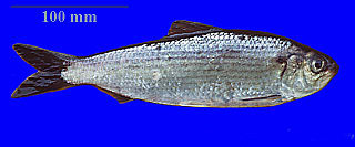
The alewife is an anadromous species of herring found in North America. It is one of the "typical" North American shads, attributed to the subgenus Pomolobus of the genus Alosa. As an adult it is a marine species found in the northern West Atlantic Ocean, moving into estuaries before swimming upstream to breed in freshwater habitats, but some populations live entirely in fresh water. It is best known for its invasion of the Great Lakes by using the Welland Canal to bypass Niagara Falls. Here, its population surged, peaking between the 1950s and 1980s to the detriment of many native species of fish. In an effort to control them biologically, Pacific salmon were introduced, only partially successfully. As a marine fish, the alewife is a US National Marine Fisheries Service "Species of Concern".

Brown trout species of brown trout

The brown trout is a European species of salmonid fish that has been widely introduced into suitable environments globally. It includes both purely freshwater populations, referred to as the riverine ecotype, Salmo trutta morpha fario, and a lacustrine ecotype, S. trutta morpha lacustris, also called the lake trout, as well as anadromous forms known as the sea trout, S. trutta morpha trutta. The latter migrates to the oceans for much of its life and returns to fresh water only to spawn. Sea trout in the Ireland and Britain have many regional names: sewin in Wales, finnock in Scotland, peal in the West Country, mort in North West England, and white trout in Ireland.

Related Research Articles

Barnstable County, Massachusetts county in Massachusetts

Barnstable County is a county located in the U.S. state of Massachusetts. As of the 2010 census, the population was 215,888. Its county seat is Barnstable. The county consists of Cape Cod and associated islands.

New Seabury, Massachusetts Census-designated place in Massachusetts, United States

New Seabury is a census-designated place (CDP) in the town of Mashpee in Barnstable County, Massachusetts, United States, on Cape Cod. The area consists primarily of summer homes for wealthy families. Attractions include a country club and the Fells Pond, Daniels Island, and Littleneck Bay neighborhoods. The population of the CDP was 717 at the 2010 census.

Cape Cod Bay A large bay of the Atlantic Ocean adjacent to the U.S. state of Massachusetts

Cape Cod Bay is a large bay of the Atlantic Ocean adjacent to the U.S. state of Massachusetts. Measuring 604 square miles (1,560 km2) below a line drawn from Brant Rock in Marshfield to Race Point in Provincetown, Massachusetts, it is enclosed by Cape Cod to the south and east, and Plymouth County, Massachusetts, to the west. To the north of Cape Cod Bay lie Massachusetts Bay and the Atlantic Ocean. Cape Cod Bay is the southernmost extremity of the Gulf of Maine. Cape Cod Bay is one of the bays adjacent to Massachusetts that give it the name Bay State. The others are Narragansett Bay, Buzzards Bay, and Massachusetts Bay.

Quashnet River

The Quashnet River, also known as Quoshnet River or Moonakis River, is a 5.1-mile-long (8.2 km) estuary in Falmouth, Massachusetts on Cape Cod. Its area is about 1-square-mile (2.6 km2).

The Childs River, also known as Child's River, is a 5.1-mile-long (8.2 km) river near Falmouth, Massachusetts on Cape Cod. Its drainage area is about 1-square-mile (2.6 km2). It has been heavily impacted by the development of cranberry bogs in its upper reaches.

Mashpee River Reservation

Mashpee River Reservation is a park in Mashpee, Massachusetts on the Mashpee River. The Trustees of Reservations owns and maintains the park.

Little Pamet River river in the United States of America

The Little Pamet River is a 1.5-mile-long (2.4 km) river in Truro, Massachusetts on Cape Cod.

Pamet River river in the United States of America

The Pamet River is a 4.2-mile-long (6.8 km) river in Truro, Massachusetts on Cape Cod. It is named for the Paomet tribe.

Mashpee and Wakeby Ponds

Mashpee Pond41°39′40″N70°29′08″W and Wakeby Pond41°40′30″N70°29′08″W are adjoining ponds in Mashpee and Sandwich, Massachusetts. When considered together, these two ponds cover 729 acres (2.95 km2) and constitute the largest freshwater pond on Cape Cod. This pair is 85 feet (26 m) deep at its deepest point. The Fishing Record for most bass cought in a day belongs to Tim walls on August 21,2016. The record for most fishing trips without a single fish cought belongs to Brendan Kelliher at 26. These kettleholes are fed by groundwater and have no inlet streams. The ponds' sole outlet stream, the Mashpee River, flows south to Popponesset Bay.

Popponesset Bay

Popponesset Bay System is a group of bays located at the towns of Mashpee and Barnstable (east), on Cape Cod, Massachusetts with a southern shore bounded by water from Nantucket Sound.

Popponesset Creek waterway in Massachusetts, United States of America

Popponesset Creek is a small waterway in Mashpee, Massachusetts on Cape Cod. On both ends, it connects with Popponesset Bay.

Popponesset Peninsula is a spit of land in Cape Cod, Massachusetts which extends from the southwestern shore of Popponesset Bay and separates it from Nantucket Sound.

Holly Marsh

Holly Marsh is a small saltwater marshland in Mashpee, Massachusetts on the shores of Popponesset Bay, Cape Cod.

Cahoon Museum of American Art art museum in Cotuit, Massachusetts

The Cahoon Museum of American Art is an art museum located in Cotuit, Massachusetts. It features fine art, folk art and American art from the 1800s through the present. Public programs include a series of annual changing exhibitions, tours, artist's talks and workshops, and family activities.

Plymouth Bay Bay at Plymouth, Massachusetts, USA

Plymouth Bay is a small, well-protected bay of the Atlantic Ocean on the western shore of larger Cape Cod Bay along the coastline of the Commonwealth of Massachusetts. Plymouth Bay retains historical significance for the landing at Plymouth Rock in 1620 by the Pilgrims aboard the Mayflower who proceeded to establish the first permanent Northern European settlement in North America at Plymouth Colony.

Washburn Island is a 330-acre (1.3 km2) island off the coast of East Falmouth, Massachusetts within Waquoit Bay. It is home to some primitive campsites and is part of the Waquoit Bay National Estuarine Research Reserve. It is part of the Town of Falmouth, in Barnstable County in the village of Waquoit.

Cotuit Historic District

The Cotuit Historic District is a historic district encompassing the heart of the village of Cotuit in Barnstable, Massachusetts. It extends along Main Street from Lowell Street in the north to Sea Street in the south, and includes portions of Ocean View Avenue and properties on adjacent roads. The oldest properties date to the late 18th century, but saw its greatest development during the height of the area's maritime industry in the mid 19th century. In the late 19th and early 20th century the area saw new development as a summer resort area. The district was listed on the National Register of Historic Places in 1987.

The Back River is a small tidal estuary in Bourne, Massachusetts on the eastern shore of Buzzards Bay. It lies just south of the Cape Cod Canal near the village of Monument Beach. It is separated from Buzzards Bay by Phinneys Harbor. The river's length is 2.1 miles (3.4 km).

Lowell Park (ballpark)

Lowell Park is a baseball venue in Cotuit, Massachusetts, home to the Cotuit Kettleers of the Cape Cod Baseball League. The former Elizabeth Lowell High School was located just to the west of the field.

References

  1. U.S. Geological Survey. National Hydrography Dataset high-resolution flowline data. The National Map, accessed April 1, 2011

Coordinates: 41°37′01″N70°27′00″W / 41.617°N 70.450°W / 41.617; -70.450

Geographic coordinate system Coordinate system

A geographic coordinate system is a coordinate system that enables every location on Earth to be specified by a set of numbers, letters or symbols. The coordinates are often chosen such that one of the numbers represents a vertical position and two or three of the numbers represent a horizontal position; alternatively, a geographic position may be expressed in a combined three-dimensional Cartesian vector. A common choice of coordinates is latitude, longitude and elevation. To specify a location on a plane requires a map projection.