Scales is a small village in south Cumbria, England, around 3.5 miles south of the town of Ulverston.
The name Scales comes from the Old Norseskali, with an Old English plural *Scalas, meaning huts.
The village has a long history, proven when mesolithic human remains were discovered in a cave in a limestone outcrop known as Scales Haggs to the east of the village.
A fragment of gravestone was once discovered in Aldingham Church, which bore an inscription to one Goditha of Scales, who it appears was an abbess and was probably the daughter of the local Lord, Michael le Fleming.
The village was once home to a small local primary school called Aldingham Parochial School, which was closed down in 1994 and amalgamated with two other local schools. The symbol of the three interconnected circles is still clearly visible on the renovated building, now a house.
The village hall, officially called Aldingham Parish Hall is known to locals as The Malt Kiln and would once have been used to dry and ferment locally grown Barley into Malt for use in vinegar, beer and bread making. Until relatively recently, it was possible to see remnants of the old process in the building but it has since been renovated.
Chackmore is a hamlet in the parish of Radclive-cum-Chackmore, in north Buckinghamshire, England. The hamlet is approached using the avenue that links Buckingham with Stowe Park.
Penrith is a market town and civil parish in the county of Cumbria, England, less than 3 miles (5 km) outside the Lake District National Park. It had a population of 15,181 at the 2011 Census. Historically in Cumberland, Penrith's local authority is currently Eden District Council, which is based in the town, as were the defunct Penrith Urban and Rural District councils. From 1974 to 2015, it was an unparished area with no local council. A civil parish was reintroduced as Penrith Town Council and first elected on 7 May 2015.
Milnthorpe is a small market town and electoral ward in the South Lakeland district of Cumbria, England. Historically in the county of Westmorland and on the A6, the town contains several old hostelries and hosts a market every Friday. It had a population of 2,199 at the 2011 Census.
Seaton is a large village and civil parish in the Allerdale borough of Cumbria, England. Historically part of Cumberland, near the Lake District National Park in England. It is home to around 5,000 people and is one of the largest villages in England. The population of the parish was measured in the 2011 Census as 5,022. Historically a part of Cumberland, it is situated on the north side of the River Derwent, across from the town of Workington, and close to the smaller village of Camerton. Seaton forms part of the Borough of Allerdale.
Coniston is a village and civil parish in the Furness region of Cumbria, England. In the 2001 census the parish had a population of 1,058, decreasing at the 2011 census to 928. Historically part of Lancashire, it is in the southern part of the Lake District National Park, between Coniston Water, the third longest lake in the Lake District, and Coniston Old Man.
Bardsea is a village in the Low Furness area of Cumbria, England. It is two miles to the south-east of Ulverston on the northern coast of Morecambe Bay. It is in the historic county of Lancashire.
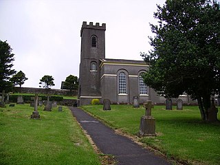
Aldingham is a village and civil parish in the South Lakeland district of Cumbria, England. Historically in Lancashire, it is situated on the east coast of the Furness peninsula, facing into Morecambe Bay, and is about 8 miles (13 km) east of Barrow-in-Furness, and 6 miles (9.7 km) south of Ulverston. The parish includes the nearby villages of Baycliff, Dendron, Leece, Gleaston, Newbiggin, Roosebeck, Scales and a number of smaller hamlets. According to the 2001 census the parish had a population of 1,187, reducing to 1,105 at the 2011 Census.
Gleaston is a village with a population of around 400 in the Furness area of South Cumbria, situated between the towns of Barrow-in-Furness, Dalton-in-Furness and Ulverston. Historically in Lancashire, the history of the village can be traced as far back as the mesolithic period and it was the centre of the manor of Muchland in the Middle Ages. Today it is largely a commuter village for the nearby towns, but its past is still visible in the remains of Gleaston Castle and Gleaston Water Mill, which is open as a tourist attraction.
Leece is a village on the Furness peninsula in Cumbria, England, between the towns of Ulverston and Barrow-in-Furness.
Muchland is a medieval manor in Low Furness in the county of Cumbria in northern England. The manor was the seat of the Lords of Aldingham, and included at its peak the villages of Bardsea, Urswick, Scales, Stainton, Sunbrick, Baycliff, Gleaston, Aldingham, Dendron, Leece and Newbiggin. The area also features the historic remains of Gleaston Castle, Aldingham Castle, Gleaston Water Mill, the Druids' Temple at Birkrigg, plus many prehistoric remains around Urswick and Scales.
Dendron is a small village in South Cumbria, England. It is situated around three miles from the town of Barrow-in-Furness. The village was once just a collection of farms, but many of the old farm buildings have now been converted into houses for commuters working in Barrow, Ulverston and Dalton.
Allithwaite is a small village in Cumbria, England, located roughly 1.2 miles (1.9 km) west of Grange-over-Sands. Most of its residents commute to local areas of Ulverston, Barrow-in-Furness, Kendal or Lancaster to work. Historically in Lancashire, Allithwaite, and the village of Cartmel situated to the north, are part of the civil parish of Lower Allithwaite. At the 2001 census, the parish had a population of 1,758, increasing to 1,831 at the 2011 Census. There is also a civil parish previously known as Upper Allithwaite which was renamed in 2018 as Lindale and Newton-in-Cartmel, and includes Lindale, Low Newton and High Newton. The population of this parish at the 2011 Census was 843.
Gleaston Castle is a medieval building in a valley about 1 kilometre (0.62 mi) north-east of the village of Gleaston. The village lies between the towns of Ulverston and Barrow-in-Furness in the Furness peninsula, Cumbria, England. Gleaston Castle has a quadrilateral plan, with a tower at each corner. The largest of these, the north-west tower, probably housed a hall.
Askam and Ireleth is a civil parish close to Barrow-in-Furness in the county of Cumbria, in North West England. Historically part of Lancashire, it originally consisted of two separate coastal villages with different origins and histories which, in recent times, have merged to become one continuous settlement. In the 2001 census the parish had a population of 3,632, reducing at the 2011 census to 3,462.
Endmoor is a small village within Cumbria, England, situated close to the A65 road. It is about 5 miles (8 km) from Kendal, just south of Oxenholme, and is in the parish of Preston Richard.
Calthwaite is a small village in rural Cumbria, England, situated between the small market town of Penrith and the larger city of Carlisle. It is within of the civil parish of Hesket and the district of Eden, and has a population of around 100 people. In 1870-72 the township had a population of 269.
Baycliff is a seaside village in the South Lakeland District of Cumbria in England. Historically in Lancashire, it lies 3 miles (4.8 km) south of Ulverston, in the civil parish of Aldingham. At the centre is a village green, and many of its buildings date from the 17th and 18th centuries. The two public houses, the Farmer's Arms and the Fisherman's Arms, stand close to the green.
Mawbray is a village in the civil parish of Holme St Cuthbert in the Allerdale borough of Cumbria, England. Historically part of Cumberland. It is located on the Solway Plain, 5.2 miles (8.4 km) south west of Silloth, 7.9 miles (12.7 km) north of Maryport, and 25 miles (40 km) west of Carlisle. The B5300, known locally as the "coast road" runs to the west of the village.
Holme St Cuthbert is a small village and civil parish in the borough of Allerdale, in the county of Cumbria, United Kingdom. The village is located approximately 23 miles to the south-west of Carlisle, Cumbria's county town, and was historically in the county of Cumberland.
Aldingham is a civil parish in the South Lakeland District of Cumbria, England. It contains 28 listed buildings that are recorded in the National Heritage List for England. Of these, one is listed at Grade I, the highest of the three grades, one is at Grade II*, the middle grade, and the others are at Grade II, the lowest grade. The parish contains villages, including Aldingham, Baycliff, Dendron, Leece, Gleaston, and Scales, and the surrounding countryside. The listed buildings include houses and associated structures, farmhouses and farm buildings, churches and items in a churchyard, a ruined castle, a Friends' burial ground, a former corn mill, two village halls, one originally a malt kiln, three follies, and four limekilns.
This page is based on this Wikipedia article Text is available under the CC BY-SA 4.0 license; additional terms may apply. Images, videos and audio are available under their respective licenses.