
The Atlantic Ocean is the second largest of the world's oceans, with an area of about 106,460,000 square kilometers. It covers approximately 20 percent of the Earth's surface and about 29 percent of its water surface area. It separates the "Old World" from the "New World".
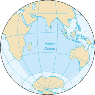
The Indian Ocean is the third largest of the world's oceanic divisions, covering 70,560,000 km2 (27,240,000 sq mi). It is bounded by Asia on the north, on the west by Africa, on the east by Australia, and on the south by the Southern Ocean or, depending on definition, by Antarctica.

Plankton are the diverse collection of organisms that live in large bodies of water and are unable to swim against a current. The individual organisms constituting plankton are called plankters. They provide a crucial source of food to many large aquatic organisms, such as fish and whales.

Oceanography, also known as oceanology, is the study of the physical and biological aspects of the ocean. It is an important Earth science, which covers a wide range of topics, including ecosystem dynamics; ocean currents, waves, and geophysical fluid dynamics; plate tectonics and the geology of the sea floor; and fluxes of various chemical substances and physical properties within the ocean and across its boundaries. These diverse topics reflect multiple disciplines that oceanographers blend to further knowledge of the world ocean and understanding of processes within: astronomy, biology, chemistry, climatology, geography, geology, hydrology, meteorology and physics. Paleoceanography studies the history of the oceans in the geologic past.

An atoll, sometimes called a coral atoll, is a ring-shaped coral reef including a coral rim that encircles a lagoon partially or completely. There may be coral islands or cays on the rim. The coral of the atoll often sits atop the rim of an extinct seamount or volcano which has eroded or subsided partially beneath the water. The lagoon forms over the volcanic crater or caldera while the higher rim remains above water or at shallow depths that permit the coral to grow and form the reefs. For the atoll to persist, continued erosion or subsidence must be at a rate slow enough to permit reef growth upward and outward to replace the lost height.

The Bering Sea is a marginal sea of the Pacific Ocean. It comprises a deep water basin, which then rises through a narrow slope into the shallower water above the continental shelves.

The Tethys Ocean, also called the Tethys Sea or the Neotethys, was an ocean during much of the Mesozoic Era located between the ancient continents of Gondwana and Laurasia, before the opening of the Indian and Atlantic oceans during the Cretaceous Period.

The Salton Sea is a shallow, saline, endorheic rift lake located directly on the San Andreas Fault, predominantly in the U.S. state of California's Imperial and Coachella valleys.

Marine geology or geological oceanography is the study of the history and structure of the ocean floor. It involves geophysical, geochemical, sedimentological and paleontological investigations of the ocean floor and coastal zone. Marine geology has strong ties to geophysics and to physical oceanography.

A mid-ocean ridge (MOR) is an underwater mountain system formed by plate tectonics, the longest mountain range on Earth. It consists of various mountains linked in chains, typically having a valley known as a rift running along its spine. This type of oceanic mountain ridge is characteristic of what is known as an 'oceanic spreading center', which is responsible for seafloor spreading. The production of new seafloor results from mantle upwelling in response to plate spreading; this isentropic upwelling solid mantle material eventually exceeds the solidus and melts. The buoyant melt rises as magma at a linear weakness in the oceanic crust, and emerges as lava, creating new crust upon cooling. A mid-ocean ridge demarcates the boundary between two tectonic plates, and consequently is termed a divergent plate boundary.

A marine transgression is a geologic event during which sea level rises relative to the land and the shoreline moves toward higher ground, resulting in flooding. Transgressions can be caused either by the land sinking or the ocean basins filling with water. Transgressions and regressions may be caused by tectonic events such as orogenies, severe climate change such as ice ages or isostatic adjustments following removal of ice or sediment load.
The Global Sea Level Observing System (GLOSS) is an Intergovernmental Oceanographic Commission program whose purpose is to measure sea level globally for long-term climate change studies. The program's purpose has changed since the 2004 Indian Ocean earthquake and the program now collects realtime measurements of sea level. The project is currently upgrading the over 290 stations it currently runs, so that they can send realtime data via satellite to newly set up national tsunami centres. They are also fitting the stations with solar panels so they can continue to operate even if the mains power supply is interrupted by severe weather. The Global Sea Level Observing System does not compete with Deep-ocean Assessment and Reporting of Tsunamis as most GLOSS transducers are located close to land masses while DART's transducers are far out in the ocean.
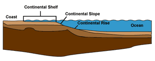
The continental margin is one of the three major zones of the ocean floor, the other two being deep-ocean basins and mid-ocean ridges. The continental margin is the shallow water area found in proximity to continent. The continental margin consists of three different features: the continental rise, the continental slope, and the continental shelf. Continental margins constitute about 28% of the oceanic area.[1]

The geological history of Earth follows the major events in Earth's past based on the geological time scale, a system of chronological measurement based on the study of the planet's rock layers (stratigraphy). Earth formed about 4.54 billion years ago by accretion from the solar nebula, a disk-shaped mass of dust and gas left over from the formation of the Sun, which also created the rest of the Solar System.

OSTM/Jason-2, or the Ocean Surface Topography Mission on the Jason-2 satellite, is an international Earth observation satellite mission that continues the sea surface height measurements begun in 1992 by the joint NASA/CNES TOPEX/Poseidon mission and followed by the NASA/CNES Jason-1 mission launched in 2001.

An ocean is a body of water that composes much of a planet's hydrosphere. On Earth, an ocean is one of the major conventional divisions of the World Ocean. These are, in descending order by area, the Pacific, Atlantic, Indian, Southern (Antarctic), and Arctic Oceans. The word "ocean" is often used interchangeably with "sea" in American English. Strictly speaking, a sea is a body of water partly or fully enclosed by land, though "the sea" refers also to the oceans.

The Caspian Sea is the world's largest inland body of water, variously classed as the world's largest lake or a full-fledged sea. It is an endorheic basin located between Europe and Asia, to the east of the Caucasus Mountains and to the west of the broad steppe of Central Asia. The sea has a surface area of 371,000 km2 and a volume of 78,200 km3. It has a salinity of approximately 1.2%, about a third of the salinity of most seawater. It is bounded by Kazakhstan to the northeast, Russia to the northwest, Azerbaijan to the west, Iran to the south, and Turkmenistan to the southeast. The Caspian Sea is home to a wide range of species and may be best known for its caviar and oil industries. Pollution from the oil industry and dams on rivers draining into the Caspian Sea have had negative effects on the organisms living in the sea.

Since at least the start of the 20th century, the average global sea level has been rising. Between 1900 and 2016, the sea level rose by 16–21 cm (6.3–8.3 in). More precise data gathered from satellite radar measurements reveal an accelerating rise of 7.5 cm (3.0 in) from 1993 to 2017, which is a trend of roughly 30 cm (12 in) per century. This acceleration is due mostly to human-caused global warming, which is driving thermal expansion of seawater and the melting of land-based ice sheets and glaciers. Between 1993 and 2018, thermal expansion of the oceans contributed 42% to sea level rise; the melting of temperate glaciers, 21%; Greenland, 15%; and Antarctica, 8%. Climate scientists expect the rate to further accelerate during the 21st century.


