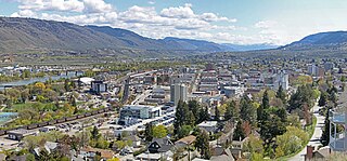
Kamloops is a city in south-central British Columbia, Canada, at the confluence of the two branches of the Thompson River and east of Kamloops Lake. It is located in the Thompson-Nicola Regional District, whose district offices are based here. The surrounding region is more commonly referred to as the Thompson Country.

Sun Peaks Resort is an alpine ski resort located in Sun Peaks, British Columbia, Canada, 56 km (35 mi) northeast of Kamloops.
Adams Lake is a large, deep, coldwater lake in British Columbia, Canada; its average depth ranks 6th in the world. The southern end of the lake is approximately 30 km (19 mi) north of the town of Chase in the Shuswap Country region of British Columbia. The lake's upper reaches lie in the northern Monashee Mountains, while its lower end penetrates the Shuswap Highland. The lake supports Chinook, Sockeye and Coho salmon, Kokanee, mountain whitefish and rainbow trout.

Canim Beach Provincial Park is a provincial park in British Columbia, Canada, located at the southwest end of Canim Lake in the Interlakes District of the South Cariboo region, adjacent to the Secwepemc Indian reserve community of Canim Lake, British Columbia just northeast of 100 Mile House. The park was established by Order-in-Council in 1956 and expanded by later legislation in 2000 and 2004 to total a current approximate of 8.2 hectares, 3.6 hectares of upland and 4.6 hectares of foreshore.

Marble Canyon Provincial Park is a provincial park in British Columbia, Canada, established in 1956 to protect Marble Canyon, a limestone formation at the south end of the Marble Range. In 2001 the park was expanded to 355 hectares to include all of Pavilion Lake due to the presence of microbialites, a type of stromatolite and the lake's importance to research into astrobiology and other fields, and in 2010, it was further expanded to 2,544 hectares. The park is also important in the culture of the Tskway'laxw people in whose territory it is located, and concealed in the side canyons of the gorge there are important pictograph sites. Not included in the park but overlooking Pavilion Lake at its farther end from the main part of the canyon is Chimney Rock, the Secwepemc'tsn name for which, K'lpalekw, means "Coyote's Penis", and is an important spiritual site. A waterfall into Crown Lake, at the park's campground, is famous among ice-climbers as "Icy BC" and the walls of Marble Canyon are a major draw to rock climbers. All three of the park's lakes are popular with recreational fishermen.

Paul Lake Provincial Park is a provincial park in British Columbia, Canada, located southwest of Heffley Lake and to the northeast of the city of Kamloops.

Tsútswecw Provincial Park is a provincial park in British Columbia, Canada, located northeast of Kamloops and northwest of Salmon Arm. It stretches along the banks of the Adams River, between the south end of Adams Lake and the western portion of Shuswap Lake.

Steelhead Provincial Park is a provincial park in British Columbia, Canada, located at the west end of Kamloops Lake near the town of Savona.

The Secwépemc, known in English as the Shuswap people, are a First Nations people residing in the interior of the Canadian province of British Columbia. They speak one of the Salishan languages, known as Secwepemc or Shuswap.
The Shuswap language is the traditional language of the Shuswap people of British Columbia. An endangered language, Shuswap is spoken mainly in the Central and Southern Interior of British Columbia between the Fraser River and the Rocky Mountains. According to the First Peoples' Cultural Council, 200 people speak Shuswap as a mother tongue, and there are 1,190 semi-speakers.
Scotch Creek is a small community in British Columbia based on summer tourism located on the shores of Shuswap Lake at the mouth of the creek of the same name.
The High Bar First Nation is a First Nations government of the Secwepemc (Shuswap) Nation, located in the Fraser Canyon-Cariboo region of the Central Interior of the Canadian province of British Columbia. It was created when the government of the then-Colony of British Columbia established an Indian Reserve system in the 1860s. It is one of three Secwepemc bands that is not a member of either the Shuswap Nation Tribal Council or the Northern Shuswap Tribal Council. The High Bar people are also partly Tsilhqot'in and have links with some Chilcotin First Nations.
The Kamloops Indian Residential School was part of the Canadian Indian residential school system. Located in Kamloops, British Columbia, it was once the largest residential school in Canada, with its enrolment peaking at 500 in the 1950s. The school was established in 1890 and remained in operation until 1969, when it was taken over by the federal government from the Catholic Church to be used as a day school residence. It closed in 1978. The school building still stands today, and is located on the Tk’emlúps te Secwépemc First Nation.
Pierre Bostonais or Pierre Hastination, better known as Tête Jaune, was an Iroquois (Haudenosaunee)-Métis trapper, fur trader, and explorer who worked for the North West Company and Hudson's Bay Company during the 18th and 19th centuries. His nickname means 'yellow head' in French and was given to him because of his blond hair. The name Bostonais refers to his probable American origin: First Nations people applied that name to American traders.

Bryoria fremontii is a dark brown, horsehair lichen that grows hanging from trees in western North America, and northern Europe and Asia. It grows abundantly in some areas, and is an important traditional food for a few First Nations in North America.
The Secwepemc Cultural Education Society (SCES) is a non-profit organization in Kamloops, British Columbia, Canada governed by representatives from thirteen bands of the Secwepemc Nation and a representative from the Secwepemc Elders Council.

Hat Creek is a tributary of the Bonaparte River in British Columbia, Canada, joining that stream at Carquile, which is also known as Lower Hat Creek and is the site of the Hat Creek Ranch heritage museum and visitor centre. The Hat Creek basin includes a broad upper plateau area encircled by the gentle but high summits of the Clear Range and, to its east, the Cornwall Hills; this area is known as Upper Hat Creek. Adjacent to Upper Hat Creek is the gateway to Marble Canyon and a rancherie of the Pavilion First Nation, who are both a St'at'imc and Secwepemc people. During the Fraser Canyon and Cariboo Gold Rushes an important trail northwards from the lower Fraser Canyon led from Foster Bar on the Fraser via Laluwissen Creek into Upper Hat Creek, then via the creek to the Bonaparte River. The economy of the basin is ranching-based and includes some of the oldest ranches in the British Columbia Interior. On the northwest edge of the Upper Hat Creek basin there is a large lignite deposit and several exploratory pits, some dating back to the 19th century but some more recent, part of an intended, but now shelved Hat Creek coal-thermal proposal.
The Kamloops Museum and Archives is a museum and archives located in the city of Kamloops, British Columbia, Canada. Located at 207 Seymour Street in downtown Kamloops, at the corner of 2nd Avenue. In addition to historical exhibits and educational programmes, the facility also is home to the city's archives, including a special collection, the Mary Balf Archives, focused around the works of Mary Balf, a prolific local historian, but including a wide array of documents from the early fur trade journals onwards.

The Adams River is a tributary to the Thompson and Fraser Rivers in British Columbia, Canada. Beginning in the Monashee Mountains to the north, the Upper Adams River flows mainly southward and eventually reaches Adams Lake. The Lower Adams River begins at the southern end of the lake and flows into the extreme western end of Shuswap Lake. The river is one of the most important sockeye salmon breeding areas in North America. The run occurs in mid-October and can bring millions of fish to a concentrated area near the river mouth. Excavations of Secwepemc villages on the river have shown a long tradition of habitation and salmon fishing in the area. The river also served as an important transportation route for early logging operations in the watershed.
