
The Sella is a river located in northwest Spain. [1] It flows through the region of Cantabria and Asturias from the Picos de Europa to the Bay of Biscay of the Atlantic Ocean at Ribadesella. [2]
The Sella is a river located in northwest Spain. [1] It flows through the region of Cantabria and Asturias from the Picos de Europa to the Bay of Biscay of the Atlantic Ocean at Ribadesella. [2]

Covadonga is one of 11 parishes in Cangas de Onís, a municipality within the province and autonomous community of Asturias, in Northwestern Spain. It is situated in the Picos de Europa mountains. With a permanent population of 58 (2008), it consists essentially of the "Real Sitio de Covadonga"/"Real Sitiu de Cuadonga" also known as the "cradle of Spain", a pilgrimage site dedicated to Our Lady of Covadonga/Cuadonga and commemorating the Battle of Covadonga of 718/722.

León is a province of northwestern Spain in the northern part of the Region of León and in the northwestern part of the autonomous community of Castile and León.

Cangas de Onís is a municipality in the eastern part of the province and autonomous community of Asturias in the northwest of Spain. The capital of the municipality is also Cangas de Onís.

The Picos de Europa are a mountain range extending for about 20 km (12 mi), forming part of the Cantabrian Mountains in northern Spain. The range is situated in the Autonomous Communities of Asturias, Cantabria and Castile and León. The highest peak is Torre de Cerredo, at an elevation of 2650 m (8,690 ft).

Llanes is a municipality of the province of Asturias, in northern Spain. Stretching for about 30 km along the coast at the extreme east of the province, Llanes is bounded to the south by the high ridge of the limestone Sierra del Cuera, which rises to over 1,100 m. The region is part of the Costa Verde of Spain, which is known for its spectacular coastal scenery, with 32 white sand beaches, and mountains covered with a deep green mantle. Llanes lies to the north of the Picos de Europa, a mountain range whose geology is almost entirely of limestone karst.

Atlantic Europe is a geographical term for the western portion of Europe which borders the Atlantic Ocean. The term may refer to the idea of Atlantic Europe as a cultural unit and/or as a biogeographical region.

The Astures or Asturs, also named Astyrs, were the Hispano-Celtic inhabitants of the northwest area of Hispania that now comprises almost the entire modern autonomous community of Principality of Asturias, the modern province of León, and the northern part of the modern province of Zamora, and eastern Trás os Montes in Portugal. They were a horse-riding highland cattle-raising people who lived in circular huts of stone drywall construction. The Albiones were a major tribe from western Asturias. Isidore of Seville gave an etymology as coming from a river Asturia, identified by David Magie with Órbigo River in the plain of León, by others the modern Esla River.
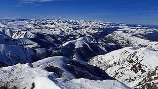
The Cantabrian Mountains or Cantabrian Range are one of the main systems of mountain ranges in Spain. They stretch for over 300 km (180 miles) across northern Spain, from the western limit of the Pyrenees to the Galician Massif in Galicia, along the coast of the Cantabrian Sea. Their easternmost end meets the Sistema Ibérico.
Cantabrian Coast is the name given to a lush natural region in Northern Spain, stretching along the Atlantic coast from the border with Portugal to the border with France. The region includes nearly all of Galicia, Asturias, and Cantabria, in addition to the northern parts of the Basque Country, as well as a small portion of Navarre.

The Naranjo de Bulnes is a limestone peak dating from the Paleozoic Era, located in the Macizo Central region of the Picos de Europa, Asturias (Spain). Its name Picu Urriellu is believed to be derived from the term Los Urrieles, which is used to describe the Macizo Central. Naranjo de Bulnes is part of the Cabrales region of Asturias, and lies within the Picos de Europa National Park.

The Cares is a river in Northern Spain that flows through the autonomous communities of Asturias and León until it joins the Deva River and flows into the Atlantic Ocean at the Bay of Biscay. It forms the Tina Mayor estuary, the natural border between Asturias and Cantabria.

The Lakes of Covadonga (el. 1134 m.) are composed of two glacial lakes located on the region of Asturias, Spain. These lakes, often also called Lakes of Enol or simply Los Lagos, are Lake Enol and Lake Ercina located in the Picos de Europa range and they are the original center of the Picos de Europa National Park, created in 1918. They are near Covadonga Sanctuary.

Liébana is a comarca of Cantabria (Spain). It covers 575 square kilometres and is located in the far southwest of Cantabria, bordering Asturias, León and Palencia. It is made up of the municipalities of: Cabezón de Liébana, Camaleño, Cillorigo de Liébana, Pesaguero, Potes, Tresviso and Vega de Liébana.
Plentuisa vendia is a species of land snail in the subfamily Helicellinae of the family Geomitridae, the hairy snails and their allies.

San Glorio is a mountain pass in the Cantabrian Mountains of Northern Spain. The pass reaches an elevation of 1610 meters along the national highway N621 which connects the city of León with Cantabria and which passes through Asturias. The pass is situated some 800m from the southern border of the Picos de Europa National Park, a park included in UNESCO's World Network of Biosphere Reserves and shared by the provinces of León, Asturias and Cantabria. The valleys of this part of the Cantabrian Mountains include sites in the European Union's Natura 2000 network and Special Protection Areas for the conservation of wild birds. San Glorio is used as a corridor by the Cantabrian brown bear Ursus arctos, catalogued in Spain as being in danger of extinction. Moreover, the slopes of the glacial valleys making up the surrounding region are home to an important variety of plant life.

Sotres is a village and parish in the Asturian municipality of Cabrales, in Spain, located 19 km from Carreña, the municipal capital, in the eastern extreme of the province.
Oceño is one of eight parishes in Peñamellera Alta, a municipality within the province and autonomous community of Asturias, in northern Spain. It is located in the Picos de Europa National Park.
Trescares is one of eight parishes in Peñamellera Alta, a municipality within the province and autonomous community of Asturias, in northern Spain. It is located in the Picos de Europa National Park.
The Turia Valley is a small valley on the western border of the Cantabrian Mountains in the northwest of Spain which is close to beaches and is divided by two autonomous communities: Asturias and Galicia. It consists of an area of 90 km2, 3,910 inhabitants and is 200 m above sea level. The two main towns are A Pontenova (Galicia) and Taramundi (Asturias).

Caldoveiro Peak is a protected mountain range in Asturias, Northern Spain, with a maximum peak of 1,357 meters, near the village of Villabre. It spans the parishes of Yernes, Proaza, Tameza, Grau (Grado), and Teberga (Teverga). Minerals found in Caldoveiro mines include Fluorite, Calcite, and Quartz. The Asturian administration uses Caldoveiro Peak in its tourism advertising, describing the mountain range as so:
The varied vegetation of this nature area and the different processes of erosion that sculpt contrasting terrain form a picturesque landscape dotted with small mountain lakes and high pastures with stone huts known as corros.
43°28′02″N5°03′51″W / 43.46722°N 5.06417°W
| | This article about a location in the Principality of Asturias, Spain, is a stub. You can help Wikipedia by expanding it. |