Seven Hills, New South Wales

Last updated

Seven Hills
Sydney,  New South Wales
Seven Hills NSW 2147, Australia - panoramio (3).jpg
Seven Hills, New South Wales
Map
Population20,095 (SAL 2021) [1]
Established1800
Postcode(s) 2147 (1730 for Seven Hills Post Office Boxes)
Elevation45 m (148 ft)
Location33 km (21 mi) north west of Sydney CBD
LGA(s)
Region Greater Western Sydney
State electorate(s)
Federal division(s) Greenway
Suburbs around Seven Hills:
Lalor Park Kings Langley Bella Vista
Blacktown Seven Hills Baulkham Hills
Prospect Toongabbie Winston Hills

Seven Hills is a suburb in the Greater Western Sydney region of Sydney, in the state of New South Wales, Australia, located 33 kilometres North West of the Sydney central business district. Seven Hills is within the local government areas of the City of Parramatta and Blacktown City councils.

Contents

Name

The name 'Seven Hills' is thought to be affiliated with Matthew Pearce, a settler in Sydney who was granted 160 acres (65 ha.) of land in 1795. Pearce named his allotment Kings Langley Farm and in that lot, he could observe seven nearby hills. The "seven hills" observed by Pearce could possibly have been the surrounding areas, which are hilly and today have "hill" in their name, such as Castle Hill, Baulkham Hills, Rooty Hill, Prospect Hill, Beaumont Hills, Rouse Hill and Constitution Hill. [2]

Though the origin of the name of the suburb still remains undocumented. Furthermore, the name was frequently used by 1803 when a notice in the Sydney Gazette that was about the dispersion of flour from stores to the residents at "Castle Hill, Seven Hills and other outposts". [3] [4]

History

Prior to European settlement in the 1790s, the area now known as Seven Hills was originally settled and occupied for hundreds, if not thousands, of years by indigenous peoples who most probably would have identified with the Warmuli and Toogagal clans, of the Darug nation. [5] The vicinity of Seven Hills was first visited by Europeans very early on in the settlement of the colony of New South Wales, possibly as early as April 1788 by Arthur Phillip [6] or more certainly by Watkin Tench in June 1789. [5]

The first land grant by the colonial administration (in what was then known as the "District of Toongabbee") was to an ex Marine soldier, John Redmond in May 1793, [7] whose grant of 60 acres (24 ha) was adjacent to a track which later became Station Road. At least 13 further grants were made in this area before 1800. Matthew Pearce (1762–1831) was granted 160 acres (65 ha)) in 1795, which he named after Kings Langley in Hertfordshire, England, where he was said to have been born. George Best and John Pye Snr were given land grants in Seven Hills in 1796. [8]

The area of the Pearce grant bounded by the present Old Windsor Road, Seven Hills Road, Chapel Lane (in what is now Baulkham Hills) and Toongabbie Creek became known as Seven Hills from about 1800, because his farm was situated near the seventh hill along the road from Parramatta. [9] In 1804 part of the Cumberland Plain in an area which later became the Grantham Estate was reserved for use as Prospect Common and at some time after this possibly around 1819 two 50 acres (20 ha) land grants were made to Samuel Haynes and Samuel Dent. [10]

Seven Hills encompassed a much larger area than now and as late as 1900, landowners as far afield as the modern suburbs of Bella Vista, Glenwood, and Parklea identified their properties as being located in Seven Hills. In the period 1959 to the 1970s, housing schemes excised land that was previously part of Seven Hills to create the suburbs of Lalor Park and Kings Langley. [2]

The railway from Parramatta to Blacktown Road station (now Blacktown) was completed as a single line in 1860. A stationmaster's residence and siding were constructed near a level crossing at what was to become Toongabbie Road (later Seven Hills Road) in December 1863. A platform was built in 1869, and stops at the station were scheduled in the timetable from September of that year. The road bridge on Seven Hills Road across the railway line was constructed in 1975, replacing the level crossing.

Grantham Heritage Park

The Haynes and Dent lots were acquired in 1897 by William Chadwick. Chadwick commissioned a Sydney architect, Byera Hadley (later to become the leading architectural academic in NSW), to build a large house on the land which he named "Melrose". [11] A much smaller house known as "Drumtochty" had been built around 1890 on the estate, to the south, at the corner of Seven Hills Road and what is now Australorp Avenue.

In 1901 the property was acquired by John Rabone who commenced a poultry breeding and experimental farm which he named "Grantham Poultry Stud". [12] In 1906 there was a further change in ownership and the farm was under the control of Martin & Co owned by a Mr Francis Martin. In 1912 the company appointed James Hadlington who concurrently held the position as the state Department of Agriculture's "Poultry Expert".

"Melrose" in 2008 Melrose-seven-hills-nsw.jpg
"Melrose" in 2008
View of the restored "Melrose" taken from the east side looking west - 2015 Melrose-eastern-aspect-2-15.jpg
View of the restored "Melrose" taken from the east side looking west – 2015
A still extant soldier settlement house in 2010 - the external fabric is almost unchanged. Soldier-settlement-house-2010.jpg
A still extant soldier settlement house in 2010 – the external fabric is almost unchanged.
This recreation reserve on Grantham Road commemorates the soldier settlers Soldiers-settlement-reserve.jpg
This recreation reserve on Grantham Road commemorates the soldier settlers

By 1917 Australia was confronting the problem of providing suitable employment for both able-bodied and disabled veterans of the First World War. This led to the development of soldier settlement schemes. Hadlington persuaded the state government to acquire the farm for such a scheme it being thought that ex-servicemen including those disabled and even limbless would be able to make an adequate living for themselves and their families from poultry farming. The transfer took place in July 1917 and the area of the farm nearer Seven Hills Station fronting (what is now) Grantham Road was subdivided into eleven 5-acre (20,000 m2) blocks for married men with the balance becoming a poultry breeding, stock and feed storage and training facility named "Grantham State Poultry Farm". [13]

Initially the ex-servicemen trainees on the farm were housed in tents but by 1918 barracks-like accommodation had been put up near Seven Hills Road. The small farms were initially taken up by "maimed settlers" who occupied small houses which had been built for them and their families. As with other such schemes some of the settlers found it hard to make a living from agriculture despite establishment loans and sustenance payments and by 1922 some of the original occupiers had abandoned the project leaving the blocks for other ex-servicemen to take over. Over the next three decades the farms were turned over to other activities or further subdivided and by the 1950s none were being used for poultry farming although many such enterprises had been successfully established in the surrounding districts principally by migrants from Europe.

In 1923 the "Grantham State Poultry Farm" was no longer required for the settlement scheme and passed to the Department of Agriculture for use as a demonstration farm and named the "Government Poultry Farm". In 1939 the farm's function changed to one of experimentation and research aimed at improving the quality of the poultry farming in the state. This led to yet another change in name with the farm becoming known as "Poultry Experiment Farm, Seven Hills". From the 1940s the farm was the site of ground breaking research (notably by Professor Bill McClymont and Dr Len Hart) into poultry husbandry and nutrition leading to significant improvements in the efficiency of poultry farming in Australia and overseas. This was officially recognised when the name was changed to the Poultry Research Station in 1960.

The 1971 office block now occupied by Blacktown City Council in 2010 Egg-board-offices.jpg
The 1971 office block now occupied by Blacktown City Council in 2010

In 1971 a new building was erected to house research and administrative functions of the research station and (later) offices of the NSW Egg Marketing Board.

By 1983 the site was known as "Agricultural Station, Seven Hills" and operations had begun to wind down. Much of the Department of Agriculture land was declared surplus to requirements and by 1989 the station had closed and the land sold off for residential development.

The cottage, "Drumtochty", - Grantham Heritage Park Seven Hills NSW after restoration. Drumtochty-Grantham-Heritage-Park-Seven-Hills-NSW.jpg
The cottage, "Drumtochty", – Grantham Heritage Park Seven Hills NSW after restoration.

In 2004 the remnant of the estate including "Melrose", "Drumtochty" (by now moved to the northern end of the estate) and the administrative building were acquired the City of Blacktown. In 2008 a plan for the use of the administration building as council offices and the development of the lands as a heritage park was announced and public comment was invited. The remnant portion has been named "Grantham Heritage Park". The entire estate, including Melrose and Drumtochty, is heritage-listed. [14]

The Heritage Park from Seven Hills Road South looking north showing some of the remnant Cumberland Plains vegetation Grantham-heritage-park-2010.jpg
The Heritage Park from Seven Hills Road South looking north showing some of the remnant Cumberland Plains vegetation

The park lands contain some of the last vestiges of Cumberland Plain woodlands and the Grantham Heritage Park Memorial commemorating the soldier settlers and trainees. [15]

Heritage listings

Seven Hills has a number of heritage-listed sites, including:

Demographics

Commercial areas

Seven Hills Plaza is a major shopping centre in Seven Hills. It is located adjacent to Prospect Highway and slightly to the south-west of the railway station. It was originally opened in 1960 as Seven Hills Regional Shopping Centre. The Seven Hills Plaza shopping centre has remained relatively unchanged since the early 2000s (with the exception of a modernised parking number plate and boom gate system) and is like a time capsule when compared to nearby shopping centres such as Blacktown's Westpoint and Paramatta's Westfield shopping centres.

There are a very large number of industrial and commercial developments contained in the area to the north of the railway bounded by the Prospect Highway, Abbott Road to the north, Old Windsor Road to the west and Blacktown Creek to the south. The studios of broadcasting station Hope 103.2 FM and the NSW Fire Brigade Station, built in 1995 are situated on the southern side of Leabons Lane near the junction with Seven Hills Road South.

Florida Place Seven hills florida place 2006.jpg
Florida Place
Leabons Lane Seven hills leabons lane.jpg
Leabons Lane

Residential areas

The suburb is predominantly residential. Florida Place, a cul-de-sac, is typical of many residential streets in Seven Hills especially those south of the railway. The buildings show a transition from the mid 20th century single storey mixed construction dwellings with an average of approx 100 m2 floorspace on 600 to 900 m2 blocks to replacement two storey brick veneer dwellings built in the 2000s with twice to three times the floorspace.

Leabons Lane, is typical of streets that are used as transport corridors with a mix of residential and light commercial use. Despite being narrow it is a busy thoroughfare linking the residential areas of south Seven Hills with Blacktown. Note the plethora of signage, traffic calming devices and utility poles strung with overhead power and TV cabling typical of streetscapes in western Sydney.

Seven Hills Railway Station looking west Rlwy stn sevo.jpg
Seven Hills Railway Station looking west

Transport

Seven Hills is located in an ideal section of Western Sydney when it comes to transport and logistics.

Sydney Trains provides regular services from Seven Hills railway station to Central railway station in 34 minutes. The suburb incorporates the localities of Grantham (the Grantham Estate) and Grantham Heights. [19] The actual seven hills are situated along the Old Windsor Road between Westmead and where today's road intersects Norwest Boulevard, Bella Vista. [20] Seven Hills railway station is a major interchange on the North Shore & Western Line of the Sydney Trains network with in excess of 2000 commuter parking spaces. Seven Hills Railway Station has the most commuter parking of any station in Western Sydney with there being more and more new parking lots being built around the station. Seven Hills is located approximately 32 km by rail or 34 minutes travel from Central railway station, on the railway line to Penrith.

The M2 Hills Motorway, M4 Motorway and Westlink M7 are three major arterial roads that link Seven Hills to other parts of Sydney. The Prospect Highway and Seven Hills Road are other major roads in the suburb.

CDC NSW provides regular services to Sydney CBD, Macquarie Park, Baulkham Hills, Bella Vista, Castle Hill, Blacktown, Toongabbie, Pendle Hill and Parramatta and Busways services to Kings Langley. The 611 bus runs along the M2 Hills Motorway from Blacktown till Macquarie Park with Seven Hills and Macquarie University being key stops. CDC NSW has two depots in Seven Hills, one on Hartley Road which is CDC NSW Seven Hills and one on Foundry Road which is also the company headquarters.

Climate

Climate data for Seven Hills (1950–1975)
MonthJanFebMarAprMayJunJulAugSepOctNovDecYear
Record high °C (°F)41.4
(106.5)
41.1
(106.0)
40.0
(104.0)
33.6
(92.5)
28.3
(82.9)
26.0
(78.8)
25.8
(78.4)
27.8
(82.0)
35.0
(95.0)
36.6
(97.9)
39.7
(103.5)
41.7
(107.1)
41.7
(107.1)
Mean daily maximum °C (°F)28.3
(82.9)
27.7
(81.9)
27.0
(80.6)
24.1
(75.4)
20.0
(68.0)
17.5
(63.5)
17.4
(63.3)
18.6
(65.5)
21.4
(70.5)
23.8
(74.8)
26.3
(79.3)
28.4
(83.1)
23.4
(74.1)
Mean daily minimum °C (°F)16.7
(62.1)
17.0
(62.6)
15.7
(60.3)
12.3
(54.1)
8.3
(46.9)
6.3
(43.3)
4.5
(40.1)
5.9
(42.6)
7.9
(46.2)
11.0
(51.8)
12.9
(55.2)
15.3
(59.5)
11.2
(52.2)
Record low °C (°F)8.9
(48.0)
8.3
(46.9)
5.3
(41.5)
4.4
(39.9)
0.8
(33.4)
−1.1
(30.0)
−3.9
(25.0)
−0.8
(30.6)
0.3
(32.5)
3.3
(37.9)
6.1
(43.0)
8.5
(47.3)
−3.9
(25.0)
Average precipitation mm (inches)102.3
(4.03)
116.5
(4.59)
104.5
(4.11)
73.7
(2.90)
69.1
(2.72)
78.9
(3.11)
42.8
(1.69)
55.2
(2.17)
45.8
(1.80)
70.3
(2.77)
83.5
(3.29)
70.1
(2.76)
912.8
(35.94)
Average precipitation days10.411.011.28.88.69.57.07.47.69.79.89.5110.3
Source: [21]

Education

Pre-schools

There are at least six early childhood educational facilities located in Seven Hills including two owned and operated by Blacktown City Council [22]

Primary schools

Secondary schools

School for special purposes (SSP)

Anzac Day commemoration in Seven Hills, 2008 Anzac day commemoration seven hills 2008.jpg
Anzac Day commemoration in Seven Hills, 2008

Notable residents

Related Research Articles

<span class="mw-page-title-main">Castle Hill, New South Wales</span> Town in New South Wales, Australia

Castle Hill is a town in Sydney, New South Wales, Australia, located 34 kilometres north-west of the Sydney central business district and 9.5 kilometres north of Parramatta. It is within the Hills District region, split between the local government areas of The Hills Shire and Hornsby Shire.

<span class="mw-page-title-main">Greater Western Sydney</span> Region of the metropolitan area of Sydney, Australia

Greater Western Sydney (GWS) is a large region of the metropolitan area of Greater Sydney, New South Wales (NSW), Australia that generally embraces the north-west, south-west, central-west, far western and the Blue Mountains sub-regions within Sydney's metropolitan area and encompasses 11 local government areas: Blacktown, Blue Mountains, Camden, Campbelltown, Cumberland, Fairfield, Hawkesbury, Liverpool, Parramatta, Penrith and Wollondilly. It includes Western Sydney, which has a number of different definitions, although the one consistently used is the region composed of ten local government authorities, most of which are members of the Western Sydney Regional Organisation of Councils (WSROC). The NSW Government's Office of Western Sydney calls the region "Greater Western Sydney".

<span class="mw-page-title-main">Westmead, New South Wales</span> Suburb of Sydney, New South Wales, Australia

Westmead is a suburb in Sydney, in the state of New South Wales, Australia. Westmead is located 26 kilometres west of the Sydney central business district in the local government area of Cumberland Council and is part of the Greater Western Sydney region.

<span class="mw-page-title-main">Marayong, New South Wales</span> Suburb of Sydney, New South Wales, Australia

Marayong is a suburb of Sydney, in the state of New South Wales, Australia. Marayong is located approximately 32 kilometres north west of the Sydney central business district, in the local government area of the City of Blacktown and is part of the Greater Western Sydney region.

<span class="mw-page-title-main">Hills District, New South Wales</span> Region in New South Wales, Australia

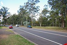
The Hills District is a region of Sydney, within the northern part of the Greater Western Sydney region of Sydney, in the state of New South Wales, Australia. Stretching from the M2 Hills Motorway in the south to the Hawkesbury River in the north and Old Windsor Road in the west to Pennant Hills Road and Berowra Creek in the east. The region is often considered to be synonymous with the local government area of The Hills Shire, however in a more expansive sense colloquial definitions can also include surrounding areas such as the western portion of the Hornsby Shire, as well as also sometimes including northern parts of City of Parramatta and Blacktown City Council.

<span class="mw-page-title-main">Bella Vista, New South Wales</span> Suburb of Sydney, New South Wales, Australia

Bella Vista is located 33 kilometres north-west of the Sydney central business district and is part of The Hills Shire. It is a suburb in the Hills District of Greater Western Sydney and is in the state of New South Wales, Australia. Bella Vista's Norwest Business Park is home to several Fortune 500 companies, a number of shopping centres, high-rise buildings, and industrial and recreational spaces.

<span class="mw-page-title-main">Toongabbie</span> Suburb of Sydney, New South Wales, Australia

Toongabbie is a suburb of Sydney, in the state of New South Wales, Australia. One of the oldest suburbs in Sydney, Toongabbie is located approximately 30 kilometres west of the Sydney central business district and is part of the Greater Western Sydney region. Toongabbie is split between the local government areas of the City of Parramatta, the City of Blacktown and Cumberland Council. The suburb is often locally referred to as "Toonie", "Toonga Bay" and "Bayside".

<span class="mw-page-title-main">Wentworthville, New South Wales</span> Suburb of Sydney, New South Wales, Australia

Wentworthville is a suburb in Sydney, in the state of New South Wales, Australia. Wentworthville is located 27 kilometres west of the Sydney central business district and is part of the Greater Western Sydney region. Wentworthville is split between the local government areas of the City of Parramatta and the Cumberland Council. Wentworthville is colloquially known as 'Wenty'.

<span class="mw-page-title-main">Wentworthville railway station</span> Railway station in Sydney, New South Wales, Australia

Wentworthville railway station is located on the Main Western line, serving the Sydney suburb of Wentworthville. It is served by Sydney Trains T1 Western and T5 Cumberland line services.

<span class="mw-page-title-main">Toongabbie railway station</span> Railway station in Sydney, New South Wales, Australia

Toongabbie railway station is located on the Main Western line, serving the Sydney suburb of Toongabbie. It is served by Sydney Trains T1 Western and T5 Cumberland line services.

<span class="mw-page-title-main">Winston Hills, New South Wales</span> Suburb of Sydney, New South Wales, Australia

Winston Hills is a suburb of Sydney, in the state of New South Wales, Australia. Winston Hills is located 28 kilometres west of the Sydney central business district in the local government areas of the City of Parramatta and The Hills Shire. Winston Hills is part of the Hills District region of Greater Western Sydney.

Glenwood is a suburb of Sydney, in the state of New South Wales, Australia. Glenwood is located 33 kilometres north-west of the Sydney central business district in the local government area of the City of Blacktown and part of the Greater Western Sydney region.

<span class="mw-page-title-main">Kings Langley, New South Wales</span> Suburb of Sydney, New South Wales, Australia

Kings Langley is a suburb of Sydney, in the state of New South Wales, Australia. Kings Langley is located 28.3 kilometres north-west in a straight line from the Sydney central business district in the local government area of Blacktown City council.

<span class="mw-page-title-main">Riverstone, New South Wales</span> Suburb of Sydney, New South Wales, Australia

Riverstone is a suburb of Sydney in the state of New South Wales, Australia. Riverstone is located 48 kilometres (30 mi) north-west of the Sydney central business district, in the Blacktown local government area and part of the Greater Western Sydney region. Originally settled in 1803 as part of a government stock farm, Riverstone is one of the oldest towns in Australia.

<span class="mw-page-title-main">Stanhope Gardens, New South Wales</span> Suburb of Sydney, New South Wales, Australia

Stanhope Gardens is a suburb of Greater Western Sydney, in the state of New South Wales, Australia. Stanhope Gardens is located 31 kilometres north-west of the Sydney central business district in the local government area of City of Blacktown.

<span class="mw-page-title-main">Pendle Hill, New South Wales</span> Suburb of Sydney, New South Wales, Australia

Pendle Hill is a suburb of Sydney, in the state of New South Wales, Australia. Pendle Hill is located 29 kilometres west of the Sydney central business district, in the local government areas of Cumberland Council and City of Parramatta and is part of the Greater Western Sydney region.

<span class="mw-page-title-main">Old Toongabbie</span> Suburb of Greater Western Sydney, New South Wales, Australia

Old Toongabbie is a suburb of Greater Western Sydney, in the state of New South Wales, Australia 29 kilometres west of the Sydney central business district in the local government area of the City of Parramatta.

<span class="mw-page-title-main">Toongabbie Creek</span> River in New South Wales, Australia

Toongabbie Creek, an urban watercourse that is part of the Parramatta River catchment, is located in Greater Western Sydney, New South Wales, Australia.

<span class="mw-page-title-main">St Andrew's Anglican Church, Seven Hills</span> Church in New South Wales, Australia

St Andrew's Anglican Church is a heritage-listed former Anglican church complex and now private residence at 313 Seven Hills Road, Seven Hills, City of Blacktown, Sydney, New South Wales, Australia. It was designed by G. H. Stoker, and built by Stoker from 1863 to 1892. It is also known as St. Andrew's Anglican Church, Hall & Rectory, St Andrew's and St Andrews. The property is privately owned. It was added to the New South Wales State Heritage Register on 2 April 1999.

<span class="mw-page-title-main">Grantham Poultry Research Station</span> Historic site in New South Wales, Australia

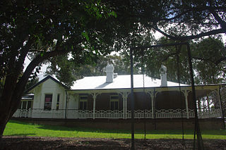
The Grantham Poultry Research Station is a heritage-listed former poultry farm and research station and now heritage reserve at 71 Seven Hills Road, Seven Hills, City of Blacktown, New South Wales, Australia. It includes two historic residences, Melrose and Drumtochty. The site is today known as the Grantham Heritage Park, and has previously been known as Seven Hills Agricultural Station and the Grantham State Poultry Farm. It was built from 1897 to 1939. It was added to the New South Wales State Heritage Register on 7 April 2000.

References

  1. Australian Bureau of Statistics (28 June 2022). "Seven Hills (NSW) (suburb and locality)". Australian Census 2021 QuickStats. Retrieved 28 June 2022.  OOjs UI icon edit-ltr-progressive.svg
  2. 1 2 Jack Brook The Seven Hills – A village divided, a suburb united 2004 ISBN   0-646-42918-3
  3. Seven Hills - A Brief History City of Parramatta. Retrieved 22 November 2023.
  4. General Orders. The Sydney Gazette and New South Wales Advertiser. p. 1. Retrieved on 9/10/2019 from https://trove.nla.gov.au/newspaper/article/625439
  5. 1 2 McGowan, Ian. "Indigenous History". Blacktown History. Retrieved 31 January 2009.
  6. McGowan, Ian. "Blacktown". Blacktown History. Retrieved 31 January 2009.
  7. "Settlement of Toongabbie". significant events from Holroyd's history. Holroyd City Council. Retrieved 31 January 2009.
  8. "Timeline for Seven Hills – Lalor Park". Blacktown City Council. Archived from the original on 23 June 2015.
  9. The Seven Hills, by Jack Brook, Blacktown & District Historical Society, 2001
  10. "Grantham Poultry Research Station (former), Seven Hills Rd Sth, Seven Hills, NSW, Australia (Place ID 101037)". Australian Heritage Database . Australian Government . Retrieved 6 February 2009.
  11. McGowan, Ian. "Heritage Buildings". Blacktown History. Retrieved 31 January 2009.
  12. "The History of Grantham". Grantham Heritage Park – Past Present and Future. Blacktown City Council. 2010.
  13. Olling, Wayne (2005). "Grantham Heritage Park Memorial". War Memorials in Australia. Archived from the original on 24 July 2008. Retrieved 26 January 2009.
  14. State Heritage Register
  15. Williams, Jane. "Grantham Heritage Park Memorial". Register of War Memorials in New South Wales. New South Wales Government. Retrieved 30 September 2011.
  16. "Dayton House". New South Wales State Heritage Register . Department of Planning & Environment. H00325. Retrieved 18 May 2018. CC BY icon.svg Text is licensed by State of New South Wales (Department of Planning and Environment) under CC-BY 4.0 licence .
  17. "Grantham Poultry Research Station (former)". New South Wales State Heritage Register . Department of Planning & Environment. H01382. Retrieved 18 May 2018. CC BY icon.svg Text is licensed by State of New South Wales (Department of Planning and Environment) under CC-BY 4.0 licence .
  18. "St. Andrew's Anglican Church, Hall & Rectory". New South Wales State Heritage Register . Department of Planning & Environment. H00057. Retrieved 18 May 2018. CC BY icon.svg Text is licensed by State of New South Wales (Department of Planning and Environment) under CC-BY 4.0 licence .
  19. Seven Hills Sydney Journal 1 June 2008
  20. Sue Rosen, Losing Ground – an environmental history of the Hawkesbury–Nepean Catchment, Hale and Iremonger, Sydney, 1995
  21. "Bureau of Meteorology".
  22. "Children's Services – Long Day Care Centres". Blacktown City Council.
  23. Matt Moran’s path from Seven Hills to celebrated chef Daily Telegraph 21 July 2015
  24. Khan, Muhammad (2024). "LinkedIn Muhammad Khan".
  25. "The Hon. Nathan Rees". Former members of the Parliament of New South Wales . Retrieved 8 May 2019.
  26. Khan, Noorullah (2024). "LinkedIn Noorullah Khan".{{cite web}}: CS1 maint: url-status (link)

33°46′40″S150°56′30″E / 33.7777°S 150.9416°E / -33.7777; 150.9416