This page is based on this
Wikipedia article Text is available under the
CC BY-SA 4.0 license; additional terms may apply.
Images, videos and audio are available under their respective licenses.

The Sudbury District is a district in Northeastern Ontario in the Canadian province of Ontario. It was created in 1894 from townships of eastern Algoma District and west Nipissing District.

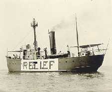
The United States lightship Huron (LV-103) is a lightvessel that was launched in 1920. She is now a museum ship moored in Pine Grove Park, Port Huron, St. Clair County, Michigan.

Division No. 1 is located in the Eastman Region of the Canadian province of Manitoba. It is located in the south-eastern corner of the province, lying between the Lake Winnipeg and Manitoba-Ontario border, and the Canada–US border. The Trans-Canada Highway runs through the Eastman Region. Also included in the division are the Buffalo Point First Nation and the Manitoba portion of the Shoal Lake 40 First Nation.
Shoal Lake 40 First Nation is an Ojibway or Ontario Saulteaux First Nation reserve located in the Eastman Region of Manitoba and the Kenora District of Ontario. The total registered population in September 2017 was 641, of which the on-reserve population was 285. The First Nation is a member of the Bimose Tribal Council, a Regional Chief's Council that is a member of the Grand Council of Treaty 3.

East Charity Shoal Light is an offshore lighthouse located near the Saint Lawrence River's entrance in northeastern Lake Ontario, due south of the city of Kingston, Ontario and approximately five miles (8 km) southwest of Wolfe Island. It is on the southeast rim of a 3,300-foot-diameter (1,000 m) submerged circular depression known as Charity Shoal Crater that may be the remnants of a meteorite impact.
The Municipality of Shoal Lake is a former rural municipality (RM) in the Canadian province of Manitoba. It was originally incorporated as a rural municipality on January 1, 2011. It ceased on January 1, 2015 as a result of its provincially mandated amalgamation with the RM of Strathclair to form the Rural Municipality of Yellowhead.

Sucker Lake is an endorheic lake in the municipality of Assiginack, Manitoulin District in Northeastern Ontario, Canada. It is on Manitoulin Island about 5 kilometres (3.1 mi) southwest of the community of Manitowaning and about 1.5 kilometres (0.93 mi) southeast of the much larger Lake Manitou. It has three islands, the largest of which is named Maple island, and there is a prevalent population of brown trout near a shoal off Bubs Island. The lake can be accessed from Sucker Lake Road, which connects to Ontario Highway 6.

Ivanhoe Lake is a 25-kilometre (16 mi) long, narrow lake in the Unorganized North Part of Sudbury District in Northeastern Ontario, Canada. It is on the Ivanhoe River in the James Bay drainage basin and is located 8 kilometres (5 mi) southwest of Foleyet on Ontario Highway 101. The lake is substantially encompassed by Ivanhoe Lake Provincial Park, except for some private cottages at the northeast end of the lake. The lake is known as Pishkanogami in the Anishinaabe language, and was once the site of Pishkanogami Post, a Hudson's Bay Company trading post. It was renamed Ivanhoe Lake in 1960.
Shoal Lake 39 First Nation is an Ojibwa or Anishinaabe First Nation, located along the northwestern shores of Shoal Lake, Ontario. It is officially known as Iskatewizaagegan #39 Independent First Nation. The total registered population of this First Nation is 585, of which 297 live on its own reserves. They are governed by a chief and council, with their current Chief Gerald Lewis having been elected in March 2016 for a two-year term.

Shoal Lake 39A is a First Nations reserve straddling the border of Manitoba and Ontario on the shores of Shoal Lake. It is one the reserves of the Iskatewizaagegan 39 Independent First Nation.

Shoal Lake 40 is a First Nations reserve straddling the border of Manitoba and Ontario on the shores of Shoal Lake. It is one the reserves of the Shoal Lake 40 First Nation.

Shoal Lake 34B2 is a First Nations reserve on the shores of Shoal Lake in northwestern Ontario. It is shared between the Iskatewizaagegan 39 Independent First Nation and Shoal Lake 40 First Nation.

Shoal Lake 31J is a First Nations reserve on Shoal Lake, northwestern Ontario. It is one of the reserves of the Anishnaabeg of Naongashiing.

Shoal Lake 34B1 is a First Nations reserve at the southwestern end of Shoal Lake in Kenora District, Ontario. It is one of the reserves of the Animakee Wa Zhing 37 First Nation.

Shoal Lake 37A is a First Nations reserve on Shoal Lake straddling the border between Manitoba and Ontario. It is one of the reserves of the Animakee Wa Zhing 37 First Nation.

Shoal Lake 39 is a First Nations reserve on Shoal Lake straddling the border between Manitoba and Ontario. It is one of the reserves of the Iskatewizaagegan 39 Independent First Nation.


