
The Arctic Archipelago, also known as the Canadian Arctic Archipelago, is an archipelago lying to the north of the Canadian continental mainland, excluding Greenland and Iceland.

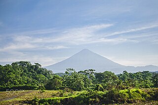
Quetzaltenango is both the seat of the namesake Department and municipality, in Guatemala. The city is located in a mountain valley at an elevation of 2,330 meters above sea level at its lowest part. It may reach above 2,400 m (7,900 ft) within the city.
Suchitepéquez is one of the 22 departments of Guatemala. Its capital is Mazatenango. It is situated in the southwestern region of Guatemala, bordering Quetzaltenango, Sololá, and Chimaltenango to the north, the Pacific Ocean to the south, Escuintla to the east, and Retalhuleu to the west.

Zunil is a town and municipality in the Quetzaltenango department of Guatemala with a surface area of 80 square kilometres (31 sq mi). The town of Zunil is located 9 kilometres (5.6 mi) from the city of Quetzaltenango, on the bank of the Salamá River. Zunil has an altitude of approximately 2,075 metres (6,808 ft) above mean sea level. The population of the municipality, which is 100% indigenous, was 14,118 at the 2018 census. The inhabitants speak Kʼicheʼ and Spanish. There are thermal baths with volcanic water around the town, for example Fuentes Georginas and Almolonga.

Almolonga is a town, with a population of 17,613, and a municipality in the Quetzaltenango Department of Guatemala, located on the road between Ciudad de Quetzaltenango and Zunil. Its population is primarily indigenous, speaking the K'iche' (Quiché) language
Cabricán is a town and municipality in the Quetzaltenango department of Guatemala. The head town of Cabricán is situated at an altitude of 2,525 m above sea level.

Cajolá is a town and municipality in the Quetzaltenango department of Guatemala. In 2023, the municipality of Cajolá had a population of 19,547, 8,776 males to 10,771 females.
Concepción Chiquirichapa is a municipality in the Guatemalan department of Quetzaltenango in the Western Highlands of Guatemala, 14 kilometers west of the departmental capital of Quetzaltenango, and 214 kilometers west of the capital Guatemala City. The municipality has a population of 17,342, 98% of whom identify as indigenous Maya-Mam and speak a dialect of Southern Mam.
Flores Costa Cuca is a town and municipality in the Quetzaltenango department of Guatemala. The municipality covers an area of 61.1 km2, is situated at an average altitude of 540 metres above sea level and has a population of 21,630.
Génova is a municipality in the Quetzaltenango department of Guatemala.
Huitán is a municipality in the Quetzaltenango department of Guatemala, situated on 16 km2 at 2600 m altitude, North-West from Quetzaltenango.
Olintepeque is a town, with a population of 31,545, and a municipality in the Quetzaltenango department of Guatemala, not far from the city of Quetzaltenango. It is located on the Xekik'el River.

San Juan Ostuncalco, is a town, with a population of 20,763, and a municipality in the Quetzaltenango department of Guatemala. Beside Spanish, local people speak the Mam language.
San Miguel Sigüilá is a municipality in the Quetzaltenango department of Guatemala.
San Felipe is a town, with a population of 17,360, and a municipality in Retalhuleu Department, situated on the road to Quetzaltenango between El Palmar, Quetzaltenango to the north-west and San Martin Zapotitlan to the south side.

Aberin is a municipality located in the province and autonomous community of Navarre, northern Spain.

The Roman Catholic Diocese of Huehuetenango, Guatemala was first erected 22 July 1961, as the Territorial Prelature of Huehuetenango. It is a suffragan diocese of the Archdiocese of Los Altos Quetzaltenango-Totonicapán. It was elevated as a diocese on 23 December 1967.

Cantel is a municipality in the Quetzaltenango Department in Guatemala. It is located 7 miles east of the city of Quetzaltenango and has an area of 52.6 km2. The town of Cantel has a population of 47,941, and is situated at an altitude of 2,370 metres.
Valle de Guadalupe is a village in Jalisco, Mexico. The population of the village is 6,705.
It has a population of around 2,000 located east of Quetzaltenango.

