Siyob Bazaar

Last updated
The entrance to Siyob Bazaar Siyob bozori (Siyab bazaar).jpg
The entrance to Siyob Bazaar
Selling Samarkand naan at Siyob Bazaar Samarkand naan at Siyob Bazaar.jpg
Selling Samarkand naan at Siyob Bazaar

Siyob Bazaar (Uzbek : Сиёб бозор), also called Siab Bazaar, is the largest bazaar in Samarkand, Uzbekistan. All daily necessities, such as "Samarkand naan", are sold.

Uzbek language Turkic language

Uzbek is a Turkic language that is the first official and only declared national language of Uzbekistan. The language of Uzbeks, it is spoken by some 33 million native speakers in Uzbekistan and elsewhere in Central Asia.

Bazaar type of public marketplace

A bazaar is a permanently enclosed marketplace or street where goods and services are exchanged or sold. The term originates from the Persian word bāzār. The term bazaar is sometimes also used to refer to the "network of merchants, bankers and craftsmen" who work in that area. Although the current meaning of the word is believed to have originated in Persia, its use has spread and now has been accepted into the vernacular in countries around the world. In Balinese, the word pasar means "market." The capital of Bali province, in Indonesia, is Denpasar, which means "north market." Souq is another word used in the Middle East for an open-air marketplace or commercial quarter.

Samarkand Place in Samarqand Region, Uzbekistan

Samarkand, alternatively Samarqand, is a city in modern-day Uzbekistan, and is one of the oldest continuously inhabited cities in Central Asia. There is evidence of human activity in the area of the city from the late Paleolithic era, though there is no direct evidence of when Samarkand was founded; some theories propose that it was founded between the 8th and 7th centuries BC. Prospering from its location on the Silk Road between China and the Mediterranean, at times Samarkand was one of the greatest cities of Central Asia.

Siyob Bazaar is located adjacent to the Bibi-Khanym Mosque, and is visited not only by local people but also by domestic and foreign tourists. [1]

Bibi-Khanym Mosque mosque

The mosque Bibi-Khanym Mosque is one of the most important monuments of Samarkand. In the 15th century it was one of the largest and most magnificent mosques in the Islamic world. By the mid-20th century only a grandiose ruin of it still survived, but major parts of the mosque were restored during the Soviet period.

See also

Chorsu Bazaar

Chorsu Bazaar is the traditional bazaar located in the center of the old town of Tashkent, the capital city of Uzbekistan. Under its blue-colored domed building and the adjacent areas, all daily necessities are sold.

Tashkent Capital in Uzbekistan

Tashkent is the capital and largest city of Uzbekistan, as well as the most populated city in ex-Soviet Central Asia with a population in 2018 of 2,485,900. It is located in the north-east of the country close to the Kazakhstan border.

Chorsu (Samarkand) bazaar in Samarqand

Chorsu in Samarkand, Uzbekistan, is a domed, hexagonal building located southeast of the Registan at the intersection of the roads connecting Samarkand, Tashkent, Bukhara, and Shahrisabz. Chorsu is a word of Persian origin meaning "crossroads," referring to this intersection.

Related Research Articles

Uzbek Soviet Socialist Republic union republic of the Soviet Union

Uzbekistan is the common English name for the Uzbek Soviet Socialist Republic and later, the Republic of Uzbekistan, that refers to the period of Uzbekistan from 1924 to 1991. as one of the constituent republics of the Soviet Union. It was governed by the Uzbek branch of the Soviet Communist Party, the only legal political party, from 1925 until 1990. From 1990 to 1991, it was a sovereign part of the Soviet Union with its own legislation. Sometimes, that period is also referred to as Soviet Uzbekistan.

Registan construction

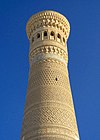
The Registan was the heart of the ancient city of Samarkand of the Timurid dynasty, now in Uzbekistan. The name Rēgistan (ریگستان) means "Sandy place" or "desert" in Persian.

Gur-e-Amir mausoleum

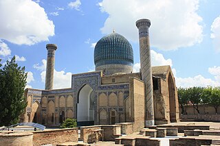
The Gūr-i Amīr or Guri Amir, is a mausoleum of the Asian conqueror Timur in Samarkand, Uzbekistan. It occupies an important place in the history of Persian-Mongolian Architecture as the precursor and model for later great Mughal architecture tombs, including Gardens of Babur in Kabul, Humayun's Tomb in Delhi and the Taj Mahal in Agra, built by Timur's Persianised descendants, the ruling Mughal dynasty of Indian Subcontinent. It has been heavily restored.

Zeravshan River river

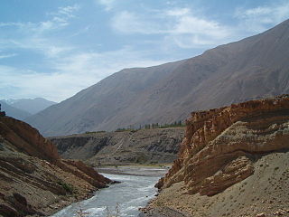
Zarafshan River is a river in Central Asia. Its name, "spreader of gold" in Persian, refers to the presence of gold-bearing sands in the upper reaches of the river. To the ancient Greeks it was known as the Polytimetus. It was also formerly known as Sughd River.

Shah-i-Zinda architectural structure

Shah-i-Zinda is a necropolis in the north-eastern part of Samarkand, Uzbekistan.

Dinamo Samarkand Stadium multi-use stadium in Samarkand, Uzbekistan

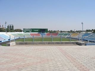
Dinamo Stadium is a multi-use stadium in Samarkand, Uzbekistan. It is currently used mostly for football matches and is the home stadium of Dynamo Samarkand.

Ulugh Beg Observatory observatory

The Ulugh Beg Observatory is an observatory in Samarkand, Uzbekistan. Built in the 1420s by the Timurid astronomer Ulugh Beg, it is considered by scholars to have been one of the finest observatories in the Islamic world. Some of the famous Islamic astronomers who worked at the observatory include Al-Kashi, Ali Qushji, and Ulugh Beg himself. The observatory was destroyed in 1449 and rediscovered in 1908.

Samarkand Oblast

The Samarkand Oblast was an oblast (province) of the Russian Empire between 1868 and 1924. It roughly corresponded to most of present-day central Uzbekistan and northwestern Tajikistan. It was created out of the northeastern part of Emirate of Bukhara. It consisted of the uyezds of Samarkand, Dzhizak, Katta-Kurgan and Khodzhent.

The Shahrisabz Museum of History and Material Culture is a museum in Shahrisabz, Uzbekistan. It was founded in 1996 on the 660th anniversary of Amir Timur's birth and contains arcaheological, ethnographic, and numismatic collections.

Samarkand State University university in Samarkand, Uzbekistan

Samarkand State University (SSU) is a major university in Samarkand, Uzbekistan established by a government decree of the Government of Uzbekistan dated 22 January 1927 in the city of Samarkand. The university is commonly known as Samarkand University

Ulugh Beg Madrasa, Samarkand educational institution

The Ulugh Beg Madrasa is a religious educational institution in Samarkand, Uzbekistan. It was built by Ulugh Beg during the Timurid dynasty at the Registan in the heart of the ancient city of Samarkand.

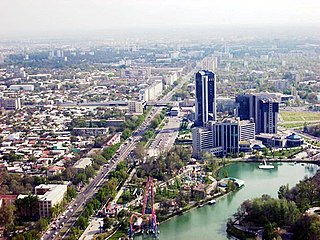
Urda was the fortress, built by Kokand people after the conquest of Tashkent.

St. John the Baptist Church, Samarkand Church in Samarkand, Uzbekistan

The St. John the Baptist Church It is the only Catholic church in the city of Samarkand, in the Asian country of Uzbekistan, where 95% are Muslims. It depends on the Apostolic Administration of Uzbekistan based in Tashkent.

Afrasiab Museum of Samarkand History museum, Historic site in Samarkand, Uzbekistan

Afrasiab Museum of Samarkand is a museum located at the historical site of Afrasiyab, one of the largest archaeological sites in the world and the ancient city that was destroyed by the Mongols in the early 13th century. Museum building and the archaeological site are located in the north-eastern part of the city of Samarkand in the Central Asian country of Uzbekistan. It bears the name of Afrasiab, mythical king and hero of Turan. Permanent exhibition of the Afrasiab Museum of Samarkand is focused on the history of the city itself as well as the surrounding region. The museum building was designed by Armenian architect Bagdasarov Arzumanyan in 1970, at the time when Uzbek Soviet Socialist Republic was still part of the Soviet Union. The opening of the museum was dedicated to the 2500th anniversary of the founding of the city of Samarkand. Thematically, the museum is divided into five rooms dedicated to different periods of life in the fort of Afrasiyab.

References

  1. Siyob Bazaar Archived 2014-03-09 at the Wayback Machine .

Coordinates: 39°39′43″N66°58′48″E / 39.662°N 66.980°E / 39.662; 66.980

Geographic coordinate system Coordinate system

A geographic coordinate system is a coordinate system that enables every location on Earth to be specified by a set of numbers, letters or symbols. The coordinates are often chosen such that one of the numbers represents a vertical position and two or three of the numbers represent a horizontal position; alternatively, a geographic position may be expressed in a combined three-dimensional Cartesian vector. A common choice of coordinates is latitude, longitude and elevation. To specify a location on a plane requires a map projection.