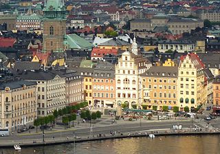
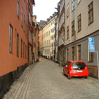
Trädgårdsgatan is a small street in Gamla stan, the old town of Stockholm, Sweden. It stretches west from Skeppar Olofs Gränd to Källargränd, just south of the Royal Palace and north of the square Stortorget. Forming a parallel to Slottsbacken and Köpmangatan, it is intercepted by Trädgårdstvärgränd. On the northern side of the street are gates leading to Bollhustäppan. It is named after the royal gardens once located along its northern side.

Österlånggatan is a street in Gamla stan, the old town of Stockholm, Sweden. Stretching southward from Slottsbacken to Järntorget, it forms a parallel street to Baggensgatan and Skeppsbron. Major sights include the statue of Saint George and the Dragon on Köpmanbrinken and the restaurant Den Gyldene Freden on number 51, established in 1722 and mentioned in Guinness Book of Records as one of the oldest with an unaltered interior.

Telegrafgränd is an alley in Gamla stan, the old town of Stockholm, Sweden. Stretching from Skeppsbron to Österlånggatan, it is a parallel street to Slottsbacken and Skeppar Karls Gränd.

Bredgränd is an alley in Gamla stan, the old town of Stockholm, Sweden. Stretching from Skeppsbron to Österlånggatan, it forms a parallel street to Skeppar Karls Gränd and Kråkgränd.

Mårten Trotzigs gränd is an alley in Gamla stan, the old town of Stockholm, Sweden. Leading from Västerlånggatan and Järntorget up to Prästgatan and Tyska Stallplan, the width of its 36 steps tapers down to a mere 90 centimetres (35 in), making the alley the narrowest street in Stockholm.
Drakens Gränd is an alley in Gamla stan, the old town of Stockholm, Sweden. Stretching from Skeppsbron to Österlånggatan, it forms a parallel street to Stora Hoparegränd and Ferkens Gränd.

Packhusgränd is an alley in Gamla stan, the old town of Stockholm, Sweden. Stretching west from Skeppsbron to Österlånggatan, it forms a parallel street to Johannesgränd and Tullgränd.

Tullgränd is an alley in Gamla stan, the old town of Stockholm, Sweden, connecting Skeppsbron to Österlånggatan. It forms a parallel street to Packhusgränd and Norra Bankogränd.

Södra Dryckesgränd is an alley in Gamla stan, the old town of Stockholm, Sweden. Connecting Skeppsbron to Järntorgsgatan, it forms a parallel street to Norra Dryckesgränd and Slussplan.

Yxsmedsgränd is an alley in Gamla stan, the old town in central Stockholm, Sweden.
Prästgatan is a street in Gamla stan, the old town in central Stockholm, Sweden, stretching from a cul-de-sac west of the Royal Palace to the street Österlånggatan in the southern corner of the old town. Prästgatan forms a parallel street to Västerlånggatan, Trångsund, Skomakargatan, and Svartmangatan. It is intercepted by Storkyrkobrinken, Ankargränd, Spektens Gränd, Solgränd, Kåkbrinken, Tyska Brinken, Tyska Stallplan, Mårten Trotzigs Gränd, and Norra Benickebrinken.

Didrik Ficks Gränd is an alley in Gamla stan, the old town of Stockholm, Sweden. Stretching from Västerlånggatan to Stora Nygatan, it forms a parallel street to Sven Vintappares Gränd and Yxsmedsgränd while passing on the south side of the small square Sven Vintappares Torg.

Gåsgränd is an alley in Gamla stan, the old town in central Stockholm, Sweden. Connecting the streets Västerlånggatan, Stora Nygatan, and Lilla Nygatan, it forms a parallel street to Ignatiigränd and Överskärargränd, and leads down to the square Munkbron on the western waterfront of the old town. On the upper stretch of the alley is a small square, Gåstorget.
Lejonstedts Gränd is an alley in Gamla stan, the old town in central stockholm, Sweden. Stretching from Stora Nygatan to Mälartorget and crossed by Lilla Nygatan, it forms a parallel street to Tyska Brinken and Kornhamnstorg. It is named after the Country marshal (lantmarskalk) and Councillor of the Realm Anders Lejonstedt (1649–1725). Lejonstedt who before knighthood was named Volimhaus, owned the block taking up the north-eastern part of the street in the late-17th century together with his brother Jakob.

Klockgjutargränd is a small alley in Gamla stan, the old town in central Stockholm, Sweden. Passing under a low vault, it connects the street Västerlånggatan to the public square and courtyard Brantingtorget, forming a parallel street to Salviigränd and Kolmätargränd.

Schönfeldts Gränd is an alley in Gamla stan, the old town in central Stockholm, Sweden. Stretching south-west from Stora Nygatan to Mälartorget it is crossed by Lilla Nygatan and Munkbrogatan, and forms a parallel street to Kåkbrinken and Lejonstedts Gränd.
Skeppar Olofs Gränd is an alley in Gamla stan, the old town in central Stockholm, Sweden. Stretching from Köpmangatan to Trädgårdsgatan, it forms a parallel street to Peder Fredags Gränd and Trädgårdstvärgränd.
Trädgårdstvärgränd is a small alley in Gamla stan, the old town in central Stockholm, Sweden. Stretching north from Köpmangatan to Trädgårdsgatan, it forms a parallel street to Skeppar Olofs Gränd and Källargränd. It is located just south of Slottsbacken and Bollhustäppan, not far from Stortorget.

Peder Fredags Gränd is a small blind alley in Gamla stan, the old town in central Stockholm, Sweden. Stretching north from Köpmangatan, it is located between Skeppar Olofs Gränd and Staffan Sasses Gränd, just south of the Tessin Palace.
Fisketorget or Fiskaretorget is a historical public square in Gamla stan, the old town in central Stockholm, Sweden. It was once located on the east shore of the island Stadsholmen, between the present streets Österlånggatan and Skeppsbron, and between the present alleys Nygränd and Brunnsgränd.