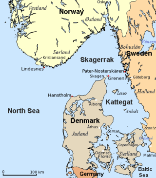
The Kattegat is a 30,000 km2 (12,000 sq mi) sea area bounded by the Jutlandic peninsula in the west, the Danish Straits islands of Denmark and the Baltic Sea to the south and the provinces of Bohuslän, Västergötland, Halland and Skåne in Sweden in the east. The Baltic Sea drains into the Kattegat through the Danish Straits. The sea area is a continuation of the Skagerrak and may be seen as a bay of the North Sea, but in traditional Scandinavian usage, this is not the case.

Vänern is the largest lake in Sweden, the largest lake in the European Union and the third-largest lake in Europe after Ladoga and Onega in Russia. It is located in the provinces of Västergötland, Dalsland, and Värmland in the southwest of the country. With its surface located at 44 metres (144 ft) with a maximum depth of 106 metres (348 ft), the lowest point of the Vänern basin is at 62 metres (203 ft) below sea level. The average depth is at a more modest 28 metres (92 ft), which means that the average point of the lake floor remains above sea level.

In physical geography, a fjord or fiord is a long, narrow sea inlet with steep sides or cliffs, created by a glacier. Fjords exist on the coasts of Antarctica, British Columbia (Canada), Chile, Denmark, Germany, Greenland (Denmark), the Faroe Islands (Denmark), Montenegro, Iceland, Ireland, Kamchatka (Russia), the Kerguelen Islands (France), Newfoundland and Labrador (Canada), New Zealand, Norway, Novaya Zemlya (Russia), Nunavut (Canada), Quebec (Canada), Argentina, Russia, South Georgia Island, Tasmania (Australia), Scotland and the states of Washington, Maine, and Alaska. Norway's coastline is estimated to be 29,000 km (18,000 mi) long with its nearly 1,200 fjords, but only 2,500 km (1,600 mi) long excluding the fjords.
Nordland is a county in Norway in the Northern Norway region, the least populous of all 11 counties, bordering Troms og Finnmark in the north, Trøndelag in the south, Norrbotten County in Sweden to the east, Västerbotten County to the south-east, and the Atlantic Ocean to the west. The county was formerly known as Nordlandene amt. The county administration is in the town of Bodø. The remote Arctic island of Jan Mayen has been administered from Nordland since 1995. In the southern part of the county is Vega, listed on the UNESCO World Heritage Site list.

Bohuslän is a Swedish province in Götaland, on the northernmost part of the country's west coast. It is bordered by Dalsland to the northeast, Västergötland to the southeast, the Skagerrak arm of the North Sea to the west, and the county of Østfold, in Norway, to the north. In English it literally means Bohus County, although it shared counties with the city of Gothenburg prior to the 1998 county merger and thus was not an administrative unit in its own right.
The Skagerrak is a strait running between the Jutland peninsula of Denmark, the east coast of Norway and the west coast of Sweden, connecting the North Sea and the Kattegat sea.

In geography, a sound is a smaller body of water usually connected to a sea or an ocean. A sound may be an inlet that is deeper than a bight and wider than a fjord; or a narrow sea channel or an ocean channel between two land masses, such as a strait; or also a lagoon between a barrier island and the mainland.
The Out Skerries are an archipelago of islets, some inhabited, in Shetland, Scotland, and are the easternmost part of Shetland. Locally, they are usually called Da Skerries or just Skerries.
Torsa is one of the Slate Islands in Argyll and Bute, Scotland. Lying east of Luing and south of Seil, this tidal island was inhabited until the 1960s. There is now only one house there, which is used for holiday lets. The underlying bedrock is slate but unlike Torsa's immediate island neighbours this has never been worked commercially. The island's name is of Norse origin but the most prominent historical structure on the island is the ruined Caisteal nan Con on the northeast shore, once held by Clan Campbell. The abundant sea life in the waters surrounding the island are protected by the Loch Sunart to the Sound of Jura Marine Protected Area.

Hyskeir or Heyskeir is a low-lying rocky islet in the Inner Hebrides, Scotland. The Hyskeir Lighthouse marks the southern entrance to the Minch.

The Archipelago Sea is a part of the Baltic Sea between the Gulf of Bothnia, the Gulf of Finland and the Sea of Åland, within Finnish territorial waters. By some definitions it contains the largest archipelago in the world by the number of islands, although many of the islands are very small and tightly clustered.
The Skerries, coming from the Old Norse word sker, are a group of sparsely vegetated rocky islets (skerries), with a total area of about 17 hectares lying 3 kilometres (1.9 mi) offshore from Carmel Head at the northwest corner of Anglesey, Wales. The islands are important as a breeding site for seabirds, and they attract divers, who come to visit the numerous shipwrecks. The Skerries Lighthouse sits atop the highest point in the islands.

Sula Sgeir is a small, uninhabited Scottish islet in the North Atlantic, 18 kilometres west of Rona. One of the most remote islands of the British Isles, it lies approximately forty nautical miles north of Lewis and is best known for its population of gannets. It has a narrow elongated shape running north-northeast to south-southwest, and is approximately 900 m long by typically 100 m wide.
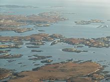
Archipelago National Park is a national park in Southwest Finland. It was established in 1983 and includes 500 km2 (190 sq mi) of land area. Most of the land is on islands smaller than 1 km2 (0.39 sq mi). The park encompasses about 2,000 of the 8,400 islets and skerries within the cooperative area. The larger islands are mainly owned by their inhabitants. Archipelago National Park is part of the UNESCO biosphere reserves and received a PAN Parks certificate in 2007.

Yell Sound is the strait running between Yell and Mainland, Shetland, Scotland. It is the boundary between the Mainland and the North Isles and it contains many small islands. Sullom Voe, on the shores of which is a substantial oil terminal, is an arm of Yell Sound.

A fjard is a large open space of water between groups of islands or mainland in archipelagos. Fjards can be found along sea coasts, in freshwater lakes or rivers. Fjard and fjord were originally the same word with the general meaning of sailable waterway. In Scandinavia, fjords dominate along the North Sea coast while fjards dominate the Baltic Sea coast.
The Torran Rocks are a group of small islands and skerries located between the islands of Mull and Colonsay in Scotland.
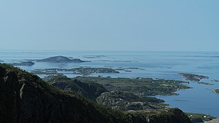
Strandflat is a landform typical of the Norwegian coast consisting of a flattish erosion surface on the coast and near-coast seabed. In Norway, strandflats provide room for settlements and agriculture, constituting important cultural landscapes. The shallow and protected waters of strandflats are valued fishing grounds that provide sustenance to traditional fishing settlements. Outside Norway proper, strandflats can be found in other high-latitude areas, such as Antarctica, Alaska, the Canadian Arctic, the Russian Far North, Greenland, Svalbard, Sweden and Scotland.

Skärgårdsnamn, is a Finnish Swedish-language book on around one hundred thousand Swedish place names in Finland's archipelagos, written by toponymy researcher Kurt Zilliacus, published in 1989.