Sleepy Creek

Last updated
Sleepy Creek
Stream
Country United States
States Virginia, West Virginia
Counties Frederick, Morgan
Source
 - locationNear Whitacre, Frederick County, Virginia
 - coordinates 39°21′17″N78°20′39″W / 39.35472°N 78.34417°W / 39.35472; -78.34417   [1]
Mouth Potomac River
 - location Sleepy Creek, Morgan County, West Virginia
 - coordinates 39°40′14″N78°05′04″W / 39.67056°N 78.08444°W / 39.67056; -78.08444 Coordinates: 39°40′14″N78°05′04″W / 39.67056°N 78.08444°W / 39.67056; -78.08444   [1]
Length44 mi (71 km)
USA West Virginia location map.svg
Red pog.svg
Location of the mouth of Sleepy Creek in West Virginia
Usa edcp relief location map.png
Red pog.svg
Sleepy Creek (the US)

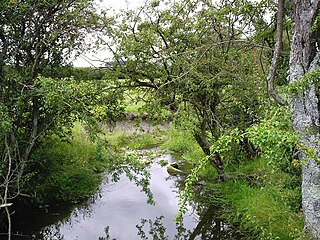
Sleepy Creek is a 44.0-mile-long (70.8 km) [2] tributary of the Potomac River in the United States, belonging to the Chesapeake Bay's watershed. The stream rises in Frederick County, Virginia, and flows through Morgan County, West Virginia before joining the Potomac near the community of Sleepy Creek.

Tributary stream or river that flows into a main stem river or lake

A tributary or affluent is a stream or river that flows into a larger stream or main stem river or a lake. A tributary does not flow directly into a sea or ocean. Tributaries and the main stem river drain the surrounding drainage basin of its surface water and groundwater, leading the water out into an ocean.

Potomac River river in the mid-Atlantic United States

The Potomac River is located within the Mid-Atlantic region of the United States and flows from the Potomac Highlands into the Chesapeake Bay. The river is approximately 405 miles (652 km) long, with a drainage area of about 14,700 square miles (38,000 km2). In terms of area, this makes the Potomac River the fourth largest river along the Atlantic coast of the United States and the 21st largest in the United States. Over 5 million people live within the Potomac watershed.

United States federal republic in North America

The United States of America (USA), commonly known as the United States or America, is a country composed of 50 states, a federal district, five major self-governing territories, and various possessions. At 3.8 million square miles, the United States is the world's third or fourth largest country by total area and is slightly smaller than the entire continent of Europe's 3.9 million square miles. With a population of over 327 million people, the U.S. is the third most populous country. The capital is Washington, D.C., and the largest city by population is New York. Forty-eight states and the capital's federal district are contiguous in North America between Canada and Mexico. The State of Alaska is in the northwest corner of North America, bordered by Canada to the east and across the Bering Strait from Russia to the west. The State of Hawaii is an archipelago in the mid-Pacific Ocean. The U.S. territories are scattered about the Pacific Ocean and the Caribbean Sea, stretching across nine official time zones. The extremely diverse geography, climate, and wildlife of the United States make it one of the world's 17 megadiverse countries.

Contents

While Sleepy Creek Lake is a part of the Sleepy Creek watershed, it is an impoundment of its tributary, Meadow Branch, in Berkeley County, West Virginia and not of Sleepy Creek itself.

Sleepy Creek Lake lake of the United States of America

Sleepy Creek Lake is a 205-acre (0.8 km2) impoundment of the Meadow Branch of Sleepy Creek in Berkeley County in West Virginia's Eastern Panhandle. The reservoir is located entirely within the Sleepy Creek Wildlife Management Area.

Meadow Branch river in the United States of America

Meadow Branch is a 16.7-mile-long (26.9 km) tributary stream of Sleepy Creek in West Virginia's Eastern Panhandle region. It passes through the Sleepy Creek Wildlife Management Area, where it is dammed to form the 205-acre (0.83 km2) Sleepy Creek Lake.
Berkeley County, West Virginia county in West Virginia, United States of America

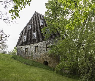
Berkeley County is located in the Shenandoah Valley in the Eastern Panhandle region of West Virginia in the United States. The county is part of the Hagerstown-Martinsburg, MD-WV Metropolitan Statistical Area.

Course

Sleepy Creek's source lies north of State Route 127 in Frederick County, Virginia, near the Hampshire County, West Virginia border at Good. From Frederick County, Sleepy Creek flows north through Morgan County, West Virginia, where it drains into the Potomac at the community of Sleepy Creek on the old Baltimore & Ohio Railroad mainline.

River source The starting point of a river

The source or headwaters of a river or stream is the furthest place in that river or stream from its estuary or confluence with another river, as measured along the course of the river.

Frederick County, Virginia county in Virginia, United States

Frederick County is located in the Commonwealth of Virginia. As of the 2010 census, the population was 78,305. Its county seat is Winchester. The county was formed in 1743 by the splitting of Orange County. It is Virginia's northernmost county.

Virginia State of the United States of America

Virginia, officially the Commonwealth of Virginia, is a state in the Southeastern and Mid-Atlantic regions of the United States located between the Atlantic Coast and the Appalachian Mountains. Virginia is nicknamed the "Old Dominion" due to its status as the first English colonial possession established in mainland North America and "Mother of Presidents" because eight U.S. presidents were born there, more than any other state. The geography and climate of the Commonwealth are shaped by the Blue Ridge Mountains and the Chesapeake Bay, which provide habitat for much of its flora and fauna. The capital of the Commonwealth is Richmond; Virginia Beach is the most populous city, and Fairfax County is the most populous political subdivision. The Commonwealth's estimated population as of 2017 is over 8.4 million.

Tributaries

Tributary streams listed from south (source) to north (mouth).

Bridges

BridgeRouteLocation
CR 38/10 BridgeFish Hatchery Road (CR 38/10) Ridge
Oakland Road BridgeOakland Road (CR 28) Oakland
CR 13 BridgeWinchester Grade Road (CR 13) Smith Crossroads
Smith Crossroads BridgeSpriggs Road (CR 13/1) Smith Crossroads
Johnson's Mill BridgeJohnson's Mill Road (CR 26) Johnsons Mill
CR 8 BridgeHighland Ridge Road (CR 8) Johnsons Mill
WV 9 Sleepy Creek BridgeMartinsburg Road (WV 9) Spohrs Crossroads
Restricted Height BridgeBurnt Mill Road (CR 1/3) Spohrs Crossroads
River Road BridgeRiver Road (CR 1) Sleepy Creek
Sleepy Creek Railroad Bridge Baltimore & Ohio Railroad Sleepy Creek

Cities and towns along Sleepy Creek

Good, West Virginia Unincorporated community in West Virginia, United States

Good is an unincorporated community in northeastern Hampshire County, West Virginia, United States atop Bear Garden Mountain. Good is located on the Bloomery Pike at I.L. Pugh Road east of Bloomery and northwest of Winchester on the West Virginia/Virginia border. Good partly lies in Frederick County, Virginia.

Johnsons Mill, West Virginia Unincorporated community in West Virginia, United States

Johnsons Mill is an unincorporated community in eastern Morgan County in the U.S. state of West Virginia on Johnson's Mill Road. It is centrally located between three other small rural hamlets along Sleepy Creek and is named for the "Johnson's Mill" that once operated here.

New Hope, Morgan County, West Virginia Unincorporated community in West Virginia, United States

New Hope is an unincorporated community in Morgan County in the U.S. state of West Virginia's Eastern Panhandle. New Hope lies at the confluence of Yellow Spring Run and Sleepy Creek.

See also

Sleepy Creek Wildlife Management Area

Sleepy Creek Wildlife Management Area is located in Morgan and Berkeley Counties in West Virginia's Eastern Panhandle. It encompasses 22,928 acres (92.79 km2), mostly covered with mixed oak and pine forest, although about 3,500 acres (14 km2) are covered with mixed hardwoods. The 205-acre (83 ha) Sleepy Creek Lake is located entirely within the WMA.

Related Research Articles

Feather River river in the United States of America

The Feather River is the principal tributary of the Sacramento River, in the Sacramento Valley of Northern California. The river's main stem is about 73 miles (117 km) long. Its length to its most distant headwater tributary is just over 210 miles (340 km). The main stem Feather River begins in Lake Oroville, where its four long tributary forks join together—the South Fork, Middle Fork, North Fork, and West Branch Feather Rivers. These and other tributaries drain part of the northern Sierra Nevada, and the extreme southern Cascades, as well as a small portion of the Sacramento Valley. The total drainage basin is about 6,200 square miles (16,000 km2), with approximately 3,604 square miles (9,330 km2) above Lake Oroville.

Cacapon River river in the United States of America

The Cacapon River, located in the Appalachian Mountains of West Virginia's Eastern Panhandle region, is an 81.0-mile-long (130.4 km) river known for its fishing, boating, wildlife, and scenery. As part of the Potomac River watershed, it is an American Heritage River.

Back Creek is a 59.5-mile-long (95.8 km) tributary of the Potomac River that flows north from Frederick County, Virginia, to Berkeley County in West Virginia's Eastern Panhandle. Back Creek originates along Frederick County's border with Hampshire County, West Virginia, at Farmer's Gap in the Great North Mountain. Its name reflects its location to the west of North Mountain. The perspective of colonists from the east in the 18th century led them to call it "Back Creek", because it lay to the back of North Mountain.

Catoctin Creek is a 14.1-mile-long (22.7 km) tributary of the Potomac River in Loudoun County, Virginia, with a watershed of 59,000 acres (240 km2). Agricultural lands make up 67 percent and forests 30 percent of Catoctin Creek's watershed. It is the main drainage system for the northern Loudoun Valley, including all of the Catoctin Valley.

Lunice Creek is a 7.3-mile-long (11.7 km) tributary of the South Branch Potomac River, belonging to the Potomac River and Chesapeake Bay watersheds. The creek is located in Grant County, West Virginia. Lunice Creek is created by its North and South Forks and empties into the South Branch at Petersburg.

Cherry Run river in the United States of America

Cherry Run is a 7.2-mile-long (11.6 km) meandering stream that forms the northern section of the boundary between Morgan and Berkeley counties in West Virginia's Eastern Panhandle. While it is mostly non-navigable, Cherry Run provides many pools of varying depths for fishing and swimming. As a tributary of the Potomac River, Cherry Run is part of the Potomac and Chesapeake Bay watersheds.

Mill Creek is a 14.5-mile-long (23.3 km) tributary of Opequon Creek, belonging to the Potomac River and Chesapeake Bay watersheds, located in Berkeley County in West Virginia's Eastern Panhandle. Its name reflects its past as a popular site for various types of mills, beginning with one constructed by Morgan Morgan in the mid-18th century near his cabin in present-day Bunker Hill.

Mill Creek (South Branch Potomac River) tributary stream of the South Branch Potomac River in Hampshire County, West Virginia, USA

Mill Creek is a 14.0-mile-long (22.5 km) tributary stream of the South Branch Potomac River, belonging to the Potomac River and Chesapeake Bay watersheds. The stream is located in Hampshire County in West Virginia's Eastern Panhandle. Mill Creek flows into the South Branch west of Romney Bridge near Vanderlip along the Northwestern Turnpike.

Big Run (South Branch Potomac River tributary) river in the United States of America

Big Run is a 4.4-mile-long (7.1 km) tributary stream of the South Branch Potomac River, belonging to the Potomac River and Chesapeake Bay watersheds. Big Run flows through the city of Romney and the campus of the West Virginia Schools for the Deaf and Blind in Hampshire County, West Virginia. The stream is known by local residents as Town Run and Town Creek.

Kettle Creek is a 7.3-mile-long (11.7 km) tributary stream of the South Fork South Branch Potomac River in Hardy and Pendleton counties in West Virginia's Eastern Panhandle. Kettle Creek rises on Mitchell Knob and flows north along the eastern flanks of Sweedlin Hill through Sweedlin Valley in the George Washington National Forest.

Pohick Creek river in the United States of America

Pohick Creek is a 14.0-mile-long (22.5 km) tributary stream of the Potomac River in Fairfax County in the U.S. state of Virginia. It takes its name from the Pohick Native American tribe once prevalent in the area.

Broad Run is a tributary of the Potomac River in Loudoun County, Virginia. The creek, located between Goose Creek and Sugarland Run, principally drains portions of eastern Loudoun County, as well as a small portion of western Fairfax County.

Buffalo Creek is a 4.1-mile-long (6.6 km) free-flowing tributary stream of the South Branch Potomac River, itself a tributary of the Potomac River, making it a part of the Chesapeake Bay watershed. Buffalo Creek is located in west-central Hampshire County in the U.S. state of West Virginia. Because the stream flows through several small farms, Buffalo Creek primarily serves agriculture purposes with segments used for livestock watering.

Paint Branch one of two headwaters of the Northeast Branch Anacostia River in Montgomery and Prince George’s counties, Maryland, U.S.

Paint Branch is a 14.0-mile-long (22.5 km) stream that flows through Montgomery County and Prince George's County, Maryland. It is a tributary of the Northeast Branch, which flows to the Anacostia River, Potomac River and the Chesapeake Bay.

The East Branch North Fork Feather River is a left tributary of the North Fork Feather River in the northern Sierra Nevada, Plumas County, California. Primarily within the Plumas National Forest, its course extends past Twain to near Belden.

North River (Cacapon River) river in the United States of America

The North River is a tributary of the Cacapon River, belonging to the Potomac River and Chesapeake Bay watersheds. The river is located in Hampshire and Hardy counties in the U.S. state of West Virginia's Eastern Panhandle. The mouth of the North River into the Cacapon is located at Forks of Cacapon. From its headwaters to its mouth, the North River spans 52.4 miles (84.3 km) in length.

Laurel Fork (North Fork South Branch Potomac River tributary)

The Laurel Fork is a 15.7-mile-long (25.3 km) stream in Virginia and West Virginia, United States. The stream flows north from Highland County, Virginia, where its source and the majority of its length is located, to its mouth in Pendleton County, West Virginia. Laurel Fork is a tributary to the North Fork South Branch Potomac River, making it a part of the Potomac River watershed. The area surrounding Laurel Fork is home to several plant and animal species found nowhere else in Virginia, and is a prime example of a northern boreal forest in the state.

References

  1. 1 2 "Sleepy Creek". Geographic Names Information System . United States Geological Survey . Retrieved August 7, 2016.
  2. U.S. Geological Survey. National Hydrography Dataset high-resolution flowline data. The National Map, accessed August 15, 2011