
Hetch Hetchy is the name of a valley, a reservoir and a water system in California in the United States. The glacial Hetch Hetchy Valley lies in the northwestern part of Yosemite National Park and is drained by the Tuolumne River. For thousands of years before the arrival of settlers from the United States in the 1850s, the valley was inhabited by Native Americans who practiced subsistence hunting-gathering. During the late 19th century, the valley was renowned for its natural beauty – often compared to that of Yosemite Valley – but also targeted for the development of water supply for irrigation and municipal interests.

The Tuolumne River flows for 149 miles (240 km) through Central California, from the high Sierra Nevada to join the San Joaquin River in the Central Valley. Originating at over 8,000 feet (2,400 m) above sea level in Yosemite National Park, the Tuolumne drains a rugged watershed of 1,958 square miles (5,070 km2), carving a series of canyons through the western slope of the Sierra. While the upper Tuolumne is a fast-flowing mountain stream, the lower river crosses a broad, fertile and extensively cultivated alluvial plain. Like most other central California rivers, the Tuolumne is dammed multiple times for irrigation and the generation of hydroelectricity.

The Grand Canyon of the Tuolumne is the notable canyon section of the river valley of the Tuolumne River, located within Yosemite National Park, in Tuolumne County and the Sierra Nevada, California.
Don Pedro Reservoir is a reservoir formed by the construction of the New Don Pedro Dam across the Tuolumne River in the Stanislaus National Forest of Tuolumne County, California, United States.

Charles Frederick Hoffmann (1838–1913) was a German-American topographer working in California U.S. from 1860 to 1880.
The Raker Act was an act of the United States Congress that permitted building of the O'Shaughnessy Dam and flooding of Hetch Hetchy Valley in Yosemite National Park, California. It is named for John E. Raker, its chief sponsor. The Act, passed by Congress in 1913 by the Wilson Administration, specified that because the source of the water and power was on public land, no private profit could be derived from the development. The plan for damming the valley was fought for years by John Muir. Construction of the dam was finished in 1923.

Wapama Falls is the larger of two waterfalls located on the northern wall of Hetch Hetchy Valley in Yosemite National Park. It flows almost year-round and during peak flow has been known to inundate the trail bridge crossing its base, making the falls impossible to pass. The falls consist of two primary drops angled roughly 60 degrees to each other, and a broad cascade at its base. Wapama Falls is fed by Lake Vernon, a few miles to the north.

Lake Vernon is located in the Tiltill Valley in the northern sector of Yosemite National Park just north of Hetch Hetchy Valley. The surface elevation of the lake is 6,568 ft (2,002 m). Due to the remote location of the lake it is usually only accessed as a backpacking destination. The area surrounding the lake was once home to a band of Sierra Miwok Indians, and numerous artifacts can be found in the area. Lake Vernon is the source of Falls Creek, which feeds Wapama Falls.

John Edward Raker was a Democratic Party Congressional representative for California. He was usually known as John E. Raker.

Cherry Creek is a large, swift-flowing stream in the Sierra Nevada mountain range, and is the largest tributary of the Tuolumne River. The creek is 40 miles (64 km) long measured to its farthest headwaters; the main stem itself is 26 miles (42 km) long, draining a watershed of 234 square miles (610 km2) in the Stanislaus National Forest. Part of the drainage also extends into the northwest corner of Yosemite National Park.

Lake Eleanor is a reservoir located in the northwestern backcountry of Yosemite National Park at an altitude of 4,657 feet (1,419 m). The reservoir has a capacity of 26,100 acre feet (32,200,000 m3) and a surface area of 953 acres (3.9 km²).

Kolana Rock is a prominent granite dome located along the southern edge of Hetch Hetchy Valley in Yosemite National Park. John Muir stated that Kolana was the Indian name for the rock. It towers 2,000 feet (610 m) above the Hetch Hetchy Reservoir.

Falls Creek, also known as the Falls River, is a tributary of the Tuolumne River in Yosemite National Park, California, United States. The creek begins at the northern boundary of the national park and flows 24 miles (39 km) to empty into the Tuolumne at Hetch Hetchy Reservoir, dropping over two well-known waterfalls. The Pacific Crest Trail and other national park trails follow the creek for much of its course.
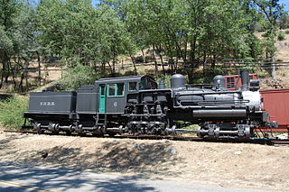
Hetch Hetchy Railroad no. 6 is a standard gauge three truck Shay locomotive built for the Hetch Hetchy Railroad by Lima Locomotive Works in 1921.
Restore Hetch Hetchy is a non-profit organization seeking to restore the Hetch Hetchy Valley in Yosemite National Park to its original condition.

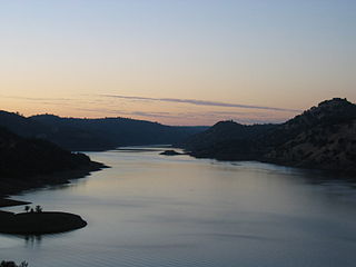
O'Shaughnessy Dam is a 430-foot (131 m) high concrete arch-gravity dam in Tuolumne County, California, in the United States. It impounds the Tuolumne River, forming the Hetch Hetchy Reservoir at the lower end of Hetch Hetchy Valley in Yosemite National Park, about 160 miles (260 km) east of San Francisco. The dam and reservoir are the source for the Hetch Hetchy Aqueduct, which provides water for over two million people in San Francisco and other municipalities of the west Bay Area. The dam is named for engineer Michael O'Shaughnessy, who oversaw its construction.

Piute Creek is a 19-mile (31 km) long stream in northern Yosemite National Park, in Tuolumne County, California. It is a major tributary of the Tuolumne River, draining a rugged and remote area of the Sierra Nevada.

Rancheria Creek is a 22-mile (35 km) long stream in northern Yosemite National Park mostly in Tuolumne County, California and is a tributary of the Tuolumne River. Draining a large area of the Sierra Nevada, it is the largest tributary of the Tuolumne within Yosemite National Park. The stream is labeled as Kerrick Creek on some early maps.


