Geology is an earth science concerned with the solid Earth, the rocks of which it is composed, and the processes by which they change over time. Geology can also refer to the study of the solid features of any terrestrial planet or natural satellite such as Mars or the Moon. Modern geology significantly overlaps all other earth sciences, including hydrology and the atmospheric sciences, and so is treated as one major aspect of integrated earth system science and planetary science.
A drumlin, from the Irish word droimnín, first recorded in 1833, and in the classical sense is an elongated hill in the shape of an inverted spoon or half-buried egg formed by glacial ice acting on underlying unconsolidated till or ground moraine.

Ammonoids are an extinct group of marine mollusc animals in the subclass Ammonoidea of the class Cephalopoda. These molluscs, commonly referred to as ammonites, are more closely related to living coleoids than they are to shelled nautiloids such as the living Nautilus species. The earliest ammonites appear during the Devonian, and the last species died out in the Cretaceous–Paleogene extinction event.
Sedimentology encompasses the study of modern sediments such as sand, silt, and clay, and the processes that result in their formation, transport, deposition and diagenesis. Sedimentologists apply their understanding of modern processes to interpret geologic history through observations of sedimentary rocks and sedimentary structures.

Flood geology is the attempt to interpret and reconcile geological features of the Earth in accordance with a literal belief in the global flood described in Genesis 6–8. In the early 19th century, diluvial geologists hypothesized that specific surface features were evidence of a worldwide flood which had followed earlier geological eras; after further investigation they agreed that these features resulted from local floods or glaciers. In the 20th century, young Earth creationists revived flood geology as an overarching concept in their opposition to evolution, assuming a recent six-day Creation and cataclysmic geological changes during the Biblical Deluge, and incorporating creationist explanations of the sequence of rock strata.
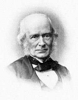
Sir Joseph Prestwich, FRS was a British geologist and businessman, known as an expert on the Tertiary Period and for having confirmed the findings of Boucher de Perthes of ancient flint tools in the Somme valley gravel beds.
Engineering geology is the application of the geology to engineering study for the purpose of assuring that the geological factors regarding the location, design, construction, operation and maintenance of engineering works are recognized and accounted for. Engineering geologists provide geological and geotechnical recommendations, analysis, and design associated with human development and various types of structures. The realm of the engineering geologist is essentially in the area of earth-structure interactions, or investigation of how the earth or earth processes impact human made structures and human activities.
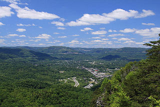
The Middlesboro crater is a meteorite crater in Kentucky, United States. It is named after the city of Middlesborough, which today occupies much of the crater.

A formation or geological formation is the fundamental unit of lithostratigraphy. A formation consists of a certain amount of rock strata that have a comparable lithology, facies or other similar properties. Formations are not defined by the thickness of their rock strata; therefore the thickness of different formations can vary widely.

Sir Archibald Geikie, was a Scottish geologist and writer.

A moulin or glacier mill is a roughly circular, vertical to nearly vertical well-like shaft within a glacier or ice sheet which water enters from the surface. The term is derived from the French word for mill.

Dimetrodon borealis, formerly known as Bathygnathus borealis, is an extinct species of pelycosaur-grade synapsid that lived about 270 million years ago (Ma) in the Early Permian. A partial maxilla or upper jaw bone from Prince Edward Island in Canada is the only known fossil of Bathygnathus. The maxilla was discovered around 1845 during the course of a well excavation in Spring Brook in the New London area and its significance was recognized by geologists John William Dawson and Joseph Leidy. It was originally described by Leidy in 1854 as the lower jaw of a dinosaur, making it the first purported dinosaur to have been found in Canada, and the second to have been found in all of North America. The bone was later identified as that of a pelycosaur. Although its current classification as a sphenacodontid synapsid was not recognized until after the discovery of its more famous relative Dimetrodonin the 1870s, Bathygnathus is notable for being the first discovered sphenacodont. A 2015 study by the researchers from U of T Mississauga, Carleton University and the Royal Ontario Museum reclassified the species into the genus Dimetrodon.
The following outline is provided as an overview of and topical guide to geology:

The Bryan Mountains are a small mountain range in the northwestern Sonoran Desert of southwestern Arizona. The range is located in southeastern Yuma County, about 75 mi southeast of Yuma and about 35 mi west of Ajo. The range is approximately ten miles long and about three miles wide at its widest point. The highpoint of the range is 1,794 feet above sea level and is located at 32°18'27"N, 113°22'46"W. The range is located entirely within the Cabeza Prieta National Wildlife Refuge.

A geologist is a scientist who studies the solid, liquid, and gaseous matter that constitutes the Earth and other terrestrial planets, as well as the processes that shape them. Geologists usually study geology, although backgrounds in physics, chemistry, biology, and other sciences are also useful. Field work is an important component of geology, although many subdisciplines incorporate laboratory work.

Overdeepening is a characteristic of basins and valleys eroded by glaciers. An overdeepened valley profile is often eroded to depths which are hundreds of metres below the deepest continuous line along a valley or watercourse. This phenomenon is observed under modern day glaciers, in salt-water fjords and fresh-water lakes remaining after glaciers melt, as well as in tunnel valleys which are partially or totally filled with sediment. When the channel produced by a glacier is filled with debris, the subsurface geomorphic structure is found to be erosionally cut into bedrock and subsequently filled by sediments. These overdeepened cuts into bedrock structures can reach a depth of several hundred metres below the valley floor.

Sherwood is an unincorporated community at the north end of Crow Creek Valley in Franklin County, Tennessee, United States. It is located along Tennessee State Route 56 13.1 miles (21.1 km) southeast of Winchester, and just north of the Alabama state line. Sherwood has a post office with ZIP code 37376.
The Kananaskis Formation is a geologic formation that is present on the western edge of the Western Canada Sedimentary Basin in the southern Canadian Rockies of western Alberta. Named after the Kananaskis Range near Banff, it was deposited during the Late Pennsylvanian sub-period of the Carboniferous period. Some of its strata host fossils of marine invertebrates.


