Spodnja Senarska

Last updated
Spodnja Senarska
Slovenia location map.svg
Red pog.svg
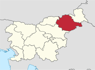
Spodnja Senarska
Location in Slovenia
Coordinates: 46°33′17.99″N15°53′16.44″E / 46.5549972°N 15.8879000°E / 46.5549972; 15.8879000 Coordinates: 46°33′17.99″N15°53′16.44″E / 46.5549972°N 15.8879000°E / 46.5549972; 15.8879000
Country Flag of Slovenia.svg Slovenia
Traditional region Styria
Statistical region Drava
Municipality Sveta Trojica v Slovenskih Goricah
Area
  Total 3.26 km2 (1.26 sq mi)
Elevation 230.7 m (756.9 ft)
Population (2002)
  Total 114
[1]

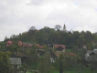
Spodnja Senarska (pronounced  [ˈspoːdnja sɛˈnaːɾska] ) is a village in the Municipality of Sveta Trojica v Slovenskih Goricah in northeastern Slovenia. It lies on the edge of the Pesnica Valley. The area was part of the traditional region of Styria and is now included in the Drava Statistical Region. [2]

Village Small clustered human settlement smaller than a town

A village is a clustered human settlement or community, larger than a hamlet but smaller than a town, with a population ranging from a few hundred to a few thousand. Though villages are often located in rural areas, the term urban village is also applied to certain urban neighborhoods. Villages are normally permanent, with fixed dwellings; however, transient villages can occur. Further, the dwellings of a village are fairly close to one another, not scattered broadly over the landscape, as a dispersed settlement.

Slovenia republic in Central Europe

Slovenia, officially the Republic of Slovenia, is a sovereign state located in southern Central Europe at a crossroads of important European cultural and trade routes. It is bordered by Italy to the west, Austria to the north, Hungary to the northeast, Croatia to the southeast, and the Adriatic Sea to the southwest. It covers 20,273 square kilometers (7,827 sq mi) and has a population of 2.07 million. One of the successor states of the former Yugoslavia, Slovenia is a parliamentary republic and a member of the United Nations, of the European Union, and of NATO. The capital and largest city is Ljubljana.

Pesnica (river) river in Styria, northeastern Slovenia

The Pesnica is a river in Styria, southeastern Austria and Styria, northeastern Slovenia. It is 69 km long, of which 65 km in Slovenia. Its catchment area is about 550 km2, of which 539 km2 in Slovenia. Its source is near Glanz an der Weinstraße, near the Austrian-Slovenian border. It passes Zgornja Kungota, Pesnica, Pernica, the castle at Hrastovec v Slovenskih Goricah, Lenart v Slovenskih Goricah, the monastery of Sveta Trojica v Slovenskih Goricah, Dornava, and Velika Nedelja, and then merges with the Drava near Ormož, on the border with Croatia.

Archaeological evidence points to Roman-era settlement of the area with burial mounds and remains of other contemporary structures. [3]

The archaeological record is the body of physical evidence about the past. It is one of the core concepts in archaeology, the academic discipline concerned with documenting and interpreting the archaeological record. Archaeological theory is used to interpret the archaeological record for a better understanding of human cultures. The archaeological record can consist of the earliest ancient findings as well as contemporary artifacts. Human activity has had a large impact on the archaeological record. Destructive human processes, such as agriculture and land development, may damage or destroy potential archaeological sites. Other threats to the archaeological record include natural phenomena and scavenging. Archaeology can be a destructive science for the finite resources of the archaeological record are lost to excavation. Therefore, archaeologists limit the amount of excavation that they do at each site and keep meticulous records of what is found. The archaeological record is the physical record of human prehistory and history, of why ancient civilizations prospered or failed and why those cultures changed and grew. It is the story of the human world.

Ancient Rome History of Rome from the 8th-century BC to the 5th-century

In historiography, ancient Rome is Roman civilization from the founding of the city of Rome in the 8th century BC to the collapse of the Western Roman Empire in the 5th century AD, encompassing the Roman Kingdom, Roman Republic and Roman Empire until the fall of the western empire. The civilization began as an Italic settlement in the Italian peninsula, dating from the 8th century BC, that grew into the city of Rome and which subsequently gave its name to the empire over which it ruled and to the widespread civilisation the empire developed. The Roman empire expanded to become one of the largest empires in the ancient world, though still ruled from the city, with an estimated 50 to 90 million inhabitants and covering 5.0 million square kilometres at its height in AD 117.

Tumulus Mound of earth and stones raised over graves

A tumulus is a mound of earth and stones raised over a grave or graves. Tumuli are also known as barrows, burial mounds or kurgans, and may be found throughout much of the world. A cairn, which is a mound of stones built for various purposes, may also originally have been a tumulus.

Related Research Articles

Sveta Trojica v Slovenskih Goricah Settlement and Municipality in Slovenia

Sveta Trojica v Slovenskih Goricah is a settlement and a municipality in northeastern Slovenia. It became an independent municipality in 2006. Before that it was part of the Municipality of Lenart. It lies in the Slovene Hills. Traditionally the area was part of Lower Styria. It is now included in the Drava Statistical Region.

Sveta Trojica, Domžale Place in Upper Carniola, Slovenia

Sveta Trojica is a settlement in the hills east of Domžale, in the Upper Carniola region of Slovenia. It includes the hamlets of Konfin and Uševk.

Sveta Trojica, Bloke Place in Inner Carniola, Slovenia

Sveta Trojica is a small village north of Velike Bloke in the Municipality of Bloke in the Inner Carniola region of Slovenia.

Ulaka, Bloke in Inner Carniola, Slovenia

Ulaka is a small village north of Velike Bloke in the Municipality of Bloke in the Inner Carniola region of Slovenia.

Drava Statistical Region Statistical region in 41

The Drava Statistical Region is a statistical region in Slovenia. The largest town in the region is Maribor. Its name comes from the Drava River and includes land on both banks along its course through Slovenia as well as the Pohorje mountains in the northeast of the region. The Drava is used for the production of hydroelectricity and the fertile land around it is used for agriculture. The share of job vacancies in all available jobs is among the highest in Slovenia and the region has a positive net migration rate but a very high natural decrease, which means an overall decrease in the population.

Gorca in Styria, Slovenia

Gorca is a settlement in the Haloze Hills above the left bank of the Dravinja River in the Municipality of Podlehnik in eastern Slovenia. The area traditionally belonged to the Styria region. It is now included in the Drava Statistical Region.

Rodni Vrh in Styria, Slovenia

Rodni Vrh is a settlement in the Haloze area of eastern Slovenia. It lies in the Municipality of Podlehnik. The area traditionally belonged to the Styria region. It is now included in the Drava Statistical Region.

Stanošina in Styria, Slovenia

Stanošina is a settlement in the Haloze Hills in the Municipality of Podlehnik in eastern Slovenia. It stretches along the main road south of Podlehnik towards the border with Croatia. The area traditionally belonged to the Styria region. It is now included in the Drava Statistical Region.

Preloka Place in White Carniola, Slovenia

Preloka is a settlement above the left bank of the Kolpa River in the Municipality of Črnomelj in the White Carniola area of southeastern Slovenia. In addition to the village of Preloka, it includes the settlements of Jakovini, Novoseli, Škavurini, and Vidine. The area is part of the traditional region of Lower Carniola and is now included in the Southeast Slovenia Statistical Region.

Špeharji in White Carniola, Slovenia

Špeharji is a small settlement on the left bank of the Kolpa River in the Municipality of Črnomelj in the White Carniola area of southeastern Slovenia. The area is part of the traditional region of Lower Carniola and is now included in the Southeast Slovenia Statistical Region.

Slavski Laz in Lower Carniola, Slovenia

Slavski Laz is a village on the left bank of the Kolpa River in the Municipality of Kostel in southern Slovenia. The area is part of the traditional region of Lower Carniola and is now included in the Southeast Slovenia Statistical Region.

Gočova in Styria, Slovenia

Gočova is a settlement in the Municipality of Sveta Trojica v Slovenskih Goricah in northeastern Slovenia. The area was part of the traditional region of Styria and is now included in the Drava Statistical Region.

Osek, Sveta Trojica v Slovenskih Goricah in Styria, Slovenia

Osek is a settlement in the Municipality of Sveta Trojica v Slovenskih Goricah in northeastern Slovenia. The area was part of the traditional region of Styria and is now included in the Drava Statistical Region.

Spodnje Verjane in Styria, Slovenia

Spodnje Verjane is a small settlement in the Municipality of Sveta Trojica v Slovenskih Goricah in northeastern Slovenia. Traditionally the area was part of Styria. It is now included with the rest of the municipality in the Drava Statistical Region.

Zgornja Senarska in Styria, Slovenia

Zgornja Senarska is a settlement in the Municipality of Sveta Trojica v Slovenskih Goricah in northeastern Slovenia. Traditionally the area was part of the Styria region and is now included in the Drava Statistical Region.

Zgornje Verjane in Styria, Slovenia

Zgornje Verjane is a settlement in the Municipality of Sveta Trojica v Slovenskih Goricah in the Slovene Hills, northeastern Slovenia. The area was part of the traditional region of Styria and is now included in the Drava Statistical Region.

Zgornji Porčič in Styria, Slovenia

Zgornji Porčič is a settlement in the Municipality of Sveta Trojica v Slovenskih Goricah in northeastern Slovenia. The area was part of the traditional region of Styria. It is now included in the Drava Statistical Region.

Dobležiče in Styria, Slovenia

Dobležiče is a settlement in the Municipality of Kozje in eastern Slovenia. The area is part of the historical Styria region. The municipality is now included in the Savinja Statistical Region.

Dolnji Ajdovec in Lower Carniola, Slovenia

Dolnji Ajdovec is a village in the Municipality of Žužemberk in southeastern Slovenia. The area is part of the historical region of Lower Carniola. The municipality is now included in the Southeast Slovenia Statistical Region.

Tržišče, Sevnica Place in Lower Carniola, Slovenia

Tržišče is a settlement along the road linking Mokronog and Sevnica in the Lower Carniola region in east-central Slovenia. It is part of the Municipality of Sevnica, which is included in the Lower Sava Statistical Region. St. George's Hill lies to the northwest of the village. The rail line from Sevnica to Trebnje runs through the settlement and has a station there. The settlement includes the hamlets of Mostec and Sveta Trojica.

References