
Babna Gora is a settlement in the Municipality of Šmarje pri Jelšah in eastern Slovenia. It lies in the hills south of Šmarje in the Kozje region. The area was traditionally part of Styria. The municipality is now included in the Savinja Statistical Region.

Belo is a settlement in the Municipality of Šmarje pri Jelšah in eastern Slovenia. It lies just east of Šmarje on the main road towards Rogaška Slatina. Traditionally, the area was part of Styria. The municipality is now included in the Savinja Statistical Region.
Bodrišna Vas is a settlement in the Municipality of Šmarje pri Jelšah in eastern Slovenia. It lies in the hills north of Šentvid pri Grobelnem in the historical region of Styria. The municipality is now included in the Savinja Statistical Region.
Dol pri Šmarju is a settlement in the hills south of Šmarje pri Jelšah in eastern Slovenia. The Municipality of Šmarje pri Jelšah is included in the Savinja Statistical Region. It is part of the historical Styria region.
Gaj is a small settlement to the east of Šmarje pri Jelšah in eastern Slovenia. Traditionally the area was part of Styria and is now included in the Savinja Statistical Region.
Gornja Vas is a village east of Šentvid pri Grobelnem in the Municipality of Šmarje pri Jelšah in eastern Slovenia. This village lies just south of the regional road from Celje to Šmarje pri Jelšah and railway line from Celje to Zagreb. The area was traditionally part of Styria. The municipality is now included in the Savinja Statistical Region.
Kamenik is a small dispersed settlement in the hills south of Šmarje pri Jelšah in eastern Slovenia. The area is part of the traditional region of Styria and is included in the Savinja Statistical Region.
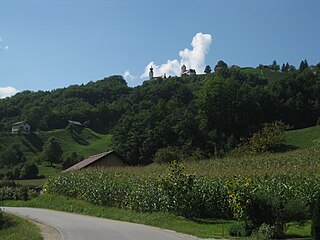
Zadrže is a settlement immediately west of Šmarje pri Jelšah in eastern Slovenia. The entire area of the Municipality of Šmarje pri Jelšah was traditionally part of Styria and is now included in the Savinja Statistical Region.
Vrh is a settlement in the hills northwest of Šmarje pri Jelšah in eastern Slovenia. The entire Municipality of Šmarje pri Jelšah lies in the traditional region of Styria and is now included in the Savinja Statistical Region.
Nova Vas pri Šmarju is a small settlement in the Municipality of Šmarje pri Jelšah in eastern Slovenia. It lies in the hills north of Šmarje on the road to Sladka Gora. The area is part of the historical region of Styria and is now included in the Savinja Statistical Region.
Pijovci is a dispersed settlement in the hills north of Šmarje pri Jelšah in eastern Slovenia. The Municipality of Šmarje pri Jelšah lies in the historical Styria region and is included in the Savinja Statistical Region.
Predenca is a settlement in the Municipality of Šmarje pri Jelšah in eastern Slovenia. It stands on a hill south of Šmarje. The area is part of the historical Styria region. The municipality is now included in the Savinja Statistical Region.
Preloge pri Šmarju is a small settlement near Šmarje pri Jelšah in eastern Slovenia. The area is part of the historical Styria region and the entire Municipality of Šmarje pri Jelšah is now included in the Savinja Statistical Region.
Pustike is a dispersed settlement in the Municipality of Šmarje pri Jelšah in eastern Slovenia. It lies in the hills northeast of Zibika. The area is part of the historical Styria region and is now included in the Savinja Statistical Region.
Sotensko pri Šmarju is a settlement in the Municipality of Šmarje pri Jelšah in eastern Slovenia. It lies in the hills north of Šmarje. The area is part of the historical Styria region. The municipality is now included in the Savinja Statistical Region.
Spodnje Mestinje is a settlement in the Municipality of Šmarje pri Jelšah in eastern Slovenia. It lies just west of the regional road from Šmarje to Podčetrtek. The area is part of the historical Styria region. The entire municipality is now included in the Savinja Statistical Region.
Spodnje Tinsko is a village in the Municipality of Šmarje pri Jelšah in eastern Slovenia. The area is part of the historical Styria region. The municipality is now included in the Savinja Statistical Region.

Stranjepronounced [ˈstɾaːnjɛ] is a settlement in the Municipality of Šmarje pri Jelšah in eastern Slovenia. It lies southeast of Šmarje. The entire area is part of the historical Styria region. The municipality is now included in the Savinja Statistical Region.
Topolovec is a small settlement in the Municipality of Šmarje pri Jelšah in eastern Slovenia. It lies just west of the regional road leading north from Šmarje towards Poljčane. Historically it is part of the Styria region. The municipality is now included in the Savinja Statistical Region.


