Spodnji Čačič

Last updated
Spodnji Čačič
Slovenia location map.svg
Red pog.svg
Spodnji Čačič
Location in Slovenia
Coordinates: 45°32′40.9″N14°42′45.39″E / 45.544694°N 14.7126083°E / 45.544694; 14.7126083 Coordinates: 45°32′40.9″N14°42′45.39″E / 45.544694°N 14.7126083°E / 45.544694; 14.7126083
Country Flag of Slovenia.svg Slovenia
Traditional region Lower Carniola
Statistical region Southeast Slovenia
Municipality Osilnica
Area
  Total 0.07 km2 (0.03 sq mi)
Elevation 545.3 m (1,789.0 ft)
Population (2002)
  Total 0
[1]

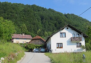
Spodnji Čačič (pronounced  [ˈspoːdnji ˈtʃaːtʃitʃ] ; German : Untertschatschitsch [2] ) is a small settlement in the Municipality of Osilnica in southern Slovenia. The area is part of the traditional region of Lower Carniola and is now included in the Southeast Slovenia Statistical Region. [3]

German language West Germanic language

German is a West Germanic language that is mainly spoken in Central Europe. It is the most widely spoken and official or co-official language in Germany, Austria, Switzerland, South Tyrol (Italy), the German-speaking Community of Belgium, and Liechtenstein. It is also one of the three official languages of Luxembourg and a co-official language in the Opole Voivodeship in Poland. The languages which are most similar to German are the other members of the West Germanic language branch: Afrikaans, Dutch, English, the Frisian languages, Low German/Low Saxon, Luxembourgish, and Yiddish. There are also strong similarities in vocabulary with Danish, Norwegian and Swedish, although those belong to the North Germanic group. German is the second most widely spoken Germanic language, after English.

Municipality An administrative division having corporate status and usually some powers of self-government or jurisdiction

A municipality is usually a single urban administrative division having corporate status and powers of self-government or jurisdiction as granted by national and regional laws to which it is subordinate. It is to be distinguished (usually) from the county, which may encompass rural territory or numerous small communities such as towns, villages and hamlets.

Osilnica Settlement in Slovenia

Osilnica is a settlement in southern Slovenia. It is located on the left bank of the Kolpa River next to the border with Croatia. It is part of the traditional region of Lower Carniola and is now included in the Southeast Slovenia Statistical Region. It is the largest settlement and the centre of the Municipality of Osilnica

The local church in the settlement is dedicated to Saint Nicholas and belongs to the Parish of Osilnica. It was first mentioned in documents dating to 1526. In 1823 it was extended and in 1942 it was burned down together with the whole settlement. After 1945 it was rebuilt. [4]

Church (building) building constructed for Christian worship

A church building or church house, often simply called a church, is a building used for Christian religious activities, particularly for Christian worship services. The term is often used by Christians to refer to the physical buildings where they worship, but it is sometimes used to refer to buildings of other religions. In traditional Christian architecture, the church is often arranged in the shape of a Christian cross. When viewed from plan view the longest part of a cross is represented by the aisle and the junction of the cross is located at the altar area.

Saint Nicholas 4th-century Christian saint

Saint Nicholas of Myra, also known as Nicholas of Bari, was an early Christian bishop of the ancient Greek city of Myra in Asia Minor during the time of the Roman Empire. He is revered by many Christians as a saint. Because of the many miracles attributed to his intercession, he is also known as Nicholas the Wonderworker. Saint Nicholas is the patron saint of sailors, merchants, archers, repentant thieves, children, brewers, pawnbrokers, and students in various cities and countries around Europe. His reputation evolved among the faithful, as was common for early Christian saints, and his legendary habit of secret gift-giving gave rise to the traditional model of Santa Claus through Sinterklaas.

A parish is a territorial entity in many Christian denominations, constituting a division within a diocese. A parish is under the pastoral care and clerical jurisdiction of a parish priest, who might be assisted by one or more curates, and who operates from a parish church. Historically, a parish often covered the same geographical area as a manor. Its association with the parish church remains paramount.

Related Research Articles

Spodnji Petelinjek in Upper Carniola, Slovenia

Spodnji Petelinjek is a small settlement east of Blagovica in the Municipality of Lukovica in the eastern part of the Upper Carniola region of Slovenia.

Spodnji Kamenščak in Styria, Slovenia

Spodnji Kamenščak is a settlement in the hills southwest of Ljutomer in northeastern Slovenia. The area traditionally belonged to the Styria region and is now included in the Mura Statistical Region.

Spodnji Ključarovci in Styria, Slovenia

Spodnji Ključarovci is a settlement in the Slovene Hills northwest of Ormož in northeastern Slovenia. The area traditionally belonged to the region of Styria. It is now included in the Drava Statistical Region.

Spodnji Leskovec in Styria, Slovenia

Spodnji Leskovec is a settlement in the valley of Lipnica Creek, a minor tributary of the Drava River in the Haloze Hills in eastern Slovenia. It is part of the Municipality of Videm. The area traditionally belonged to the Styria region. It is now included in the Drava Statistical Region.

Spodnji Gabernik in Styria, Slovenia

Spodnji Gabernik is a settlement in the Municipality of Rogaška Slatina in eastern Slovenia. The entire area was traditionally part of the region of Styria. It is now included in the Savinja Statistical Region.

Spodnji Stari Grad in Styria, Slovenia

Spodnji Stari Grad is a settlement on the left bank of the Sava River in the Municipality of Krško in eastern Slovenia. The area was traditionally part of Styria. It is now included with the rest of the municipality in the Lower Sava Statistical Region.

Papeži Village in Lower Carniola, Slovenia

Papeži is a small village in the Municipality of Osilnica in southern Slovenia. The area is part of the traditional region of Lower Carniola and is now included in the Southeast Slovenia Statistical Region.

Zgornji Čačič in Lower Carniola, Slovenia

Zgornji Čačič is a small settlement in the Municipality of Osilnica in southern Slovenia. It is part of the traditional region of Lower Carniola and is now included in the Southeast Slovenia Statistical Region.

Spodnji Hotič in Styria, Slovenia

Spodnji Hotič is a settlement on the left bank of the Sava River north of Litija in central Slovenia. Traditionally the area was part of Lower Styria and is now included with the rest of the Municipality of Litija in the Central Sava Statistical Region.

Spodnji Log, Litija in Lower Carniola, Slovenia

Spodnji Log is a village on the right bank of the Sava River in the Municipality of Litija in central Slovenia. The area is included with the rest of the municipality in the Central Sava Statistical Region. Traditionally, it was part of the Lower Carniola region.

Spodnji Prekar in Upper Carniola, Slovenia

Spodnji Prekar is a small settlement in the hills above the left bank of the Sava River in the Municipality of Moravče in central Slovenia. Traditionally the area was part of Upper Carniola. It is now included with the rest of the municipality in the Central Slovenia Statistical Region.

Spodnji Tuštanj in Upper Carniola, Slovenia

Spodnji Tuštanj is a settlement in the Municipality of Moravče in central Slovenia. Traditionally the area was part of the Upper Carniola region. It is now included with the rest of the municipality in the Central Slovenia Statistical Region.

Spodnji Gaj pri Pragerskem in Styria, Slovenia

Spodnji Gaj pri Pragerskem is a small settlement just east of Pragersko in northeastern Slovenia. It belongs to the Municipality of Kidričevo. The area is part of the traditional region of Styria. It is now included with the rest of the municipality in the Drava Statistical Region.

Spodnji Porčič in Styria, Slovenia

Spodnji Porčič is a settlement in the Slovene Hills in the Municipality of Lenart in northeastern Slovenia. The southern part of the settlement is part of the Lenart industrial zone. The area was part of the traditional region of Styria. It is now included in the Drava Statistical Region.

Spodnji Jakobski Dol in Styria, Slovenia

Spodnji Jakobski Dol is a settlement in the Municipality of Pesnica in northeastern Slovenia. It lies in the Slovene Hills, part of the traditional region of Styria. The municipality is now included in the Drava Statistical Region.

Spodnji Jernej in Styria, Slovenia

Spodnji Jernej is a settlement in the hills northeast of Loče in the Municipality of Slovenske Konjice in eastern Slovenia. Traditionally the area was part of the Styria region. The municipality is now included in the Savinja Statistical Region. In 1999 a part of the settlement was administratively separated to form the new settlement of Štajerska Vas.

Spodnji Pokštajn in Lower Carniola, Slovenia

Spodnji Pokštajn is a former village in the Municipality of Kočevje in southern Slovenia. The area is part of the traditional region of Lower Carniola and is now included in the Southeast Slovenia Statistical Region. Its territory is now part of the village of Podlesje.

Spodnji Kašelj in Upper Carniola, Slovenia

Spodnji Kašelj is a formerly independent settlement in the eastern part of the capital Ljubljana in central Slovenia. It is a compact settlement above the left bank of the Ljubljanica River between Zgornji Kašelj and Zalog. It was part of the traditional region of Upper Carniola and is now included with the rest of the municipality in the Central Slovenia Statistical Region.

Spodnji Šemnik in Upper Carniola, Slovenia

Spodnji Šemnik is a small settlement in the Municipality of Zagorje ob Savi in central Slovenia. The settlement is part of the traditional region of the Upper Carniola and is included in the Central Sava Statistical Region.

References

  1. Statistical Office of the Republic of Slovenia
  2. Leksikon občin kraljestev in dežel zastopanih v državnem zboru, vol. 6: Kranjsko. 1906. Vienna: C. Kr. Dvorna in Državna Tiskarna, p. 40.
  3. Oslinica municipal site
  4. Slovenian Ministry of Culture register of national heritage reference number ešd 2095