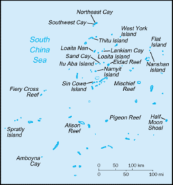
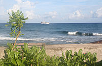
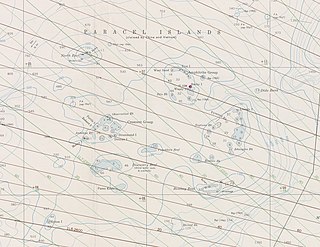
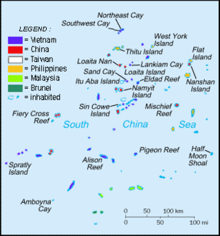
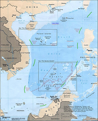
The Spratly Islands[1] are a disputedarchipelago in the South China Sea. Composed of islands, islets, cays,[2] and more than 100 reefs, sometimes grouped in submerged old atolls,[3] the archipelago lies off the coasts of the Philippines, Malaysia, and southern Vietnam. Named after the 19th-century British whaling captain Richard Spratly who sighted Spratly Island in 1843, the islands contain less than 2km2 (490 acres) of naturally occurring land area, which is spread over an area of more than 425,000km2 (164,000sqmi).
The Spratly Islands are one of the major archipelagos in the South China Sea which complicate governance and economics in this part of Southeast Asia due to their location in strategic shipping lanes. The islands are largely uninhabited, but offer rich fishing grounds and may contain significant oil and natural gas reserves,[4][5][6] and as such are important to the claimants in their attempts to establish international boundaries. Some of the islands have civilian settlements, but of the approximately 45 islands, cays, reefs and shoals that are occupied, all contain structures that are occupied by military forces from Malaysia, China (PRC), Taiwan (ROC), the Philippines, and Vietnam. Additionally, Brunei has claimed an exclusive economic zone in the southeastern part of the Spratly Islands, which includes the uninhabited Louisa Reef.
In 1939, the Spratly Islands were coral islets mostly inhabited by seabirds.[2] Despite the Spratly Islands naturally consisting of 19 islands (see below), according to a Chinese 1986 source, the Spratly Islands consist of 14 islands or islets, 6 banks, 113 submerged reefs, 35 underwater banks and 21 underwater shoals.[7]
The northeast part of the Spratly Islands is known as Dangerous Ground and is characterised by many low islands, sunken reefs, and degraded, sunken atolls with coral often rising abruptly from ocean depths greater than 1,000 metres (3,000ft) – all of which makes the area dangerous for navigation.
The islands are all of similar nature; they are cays (or keys): sand islands formed on old degraded and submerged coral reefs.
The Spratly Islands contain almost no arable land, are largely uninhabited, and very few of the islands have a permanent drinkable water supply.[5][8]
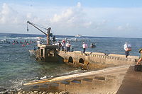
Natural resources include fish, guano, oil and natural gas.[9] Economic activity has included commercial fishing, shipping, guano mining, oil and gas exploitation, and more recently, tourism. The Spratly Islands are located near several primary shipping lanes.
The islands and cays, listed in descending order of naturally occurring area, are:
The dismemberment and subsidence of continental crust into horsts,rotated fault blocks and half-grabens that underlie the Spratly Islands and surrounding sea bottom occurred in two distinct periods. They occurred as the result of the tectonic stretching of continental crust along underlying deeply rooted detachment faults. During the Late Cretaceous and Early Oligocene,the earliest period of tectonic stretching of continental crust and formation of horsts,half-grabens,and rotated fault-blocks occurred in association with the rifting and later sea-floor spreading that created the South China Sea. During the Late Oligocene-Early Miocene additional stretching and block faulting of continental crust occurred within the Spratly Islands and adjacent Dangerous Ground. During and after this period of tectonic activity,corals and other marine life colonised the crests of the horsts and other ridges that lay in shallow water. The remains of these organisms accumulated over time as biogenic carbonates that comprise the current day reefs,shoals and cays of the Spratly Islands. Starting with their formation in Late Cretaceous,fine-grained organic-rich marine sediments accumulated within the numerous submarine half-grabens that underlie sea bottom within the Dangerous Ground region.[17][18][19]
The geological surveys show localised areas within the Spratly Islands region are favourable for the accumulation of economic oil and gas reserves. They include thick sequences of Cenozoic sediments east of the Spratly Islands. Southeast and west of them,there also exist thick accumulations of sediments that possibly might contain economic oil and gas reserves,which lie closer to the Spratly Islands.[4][20]
Ecology
In some cays in the Spratly Islands,the sand and pebble sediments form the beaches and spits around the island. Under the influence of the dominant wind direction,which changes seasonally,these sediments move around the island to change the shape and size of the island. For example,Spratly Island is larger during the northeast monsoon (about 700 by 300 metres (2,300ft ×980ft)),and smaller during the southwest monsoon (approximately 650 by 320 metres (2,130ft ×1,050ft)).[21]
Some islands may contain fresh groundwater fed by rain. Groundwater levels fluctuate during the day with the rhythm of the tides.[22]
Phosphates from bird faeces (guano) are mainly concentrated in the beach rocks by the way of exchange-endosmosis. The principal minerals bearing phosphate are podolite,lewistonite and dehonite.[23]
Coral reefs
Coral reefs are the predominant structures of these islands;the Spratly group contains over 600 coral reefs in total.[3] In April 2015 the New York Times reported that China were using "scores of dredgers" to convert Fiery Cross Reef and several other reefs into military facilities.[24][25]
Vegetation
Little vegetation grows on these islands,which are subject to intense monsoons. Larger islands are capable of supporting tropical forest,scrub forest,coastal scrub and grasses. It is difficult to determine which species have been introduced or cultivated by humans. Taiping Island (Itu Aba) was reportedly covered with shrubs,coconut,and mangroves in 1938;pineapple was also cultivated there when it was profitable. Other accounts mention papaya,banana,palm,and even white peach trees growing on one island. A few islands that have been developed as small tourist resorts had soil and trees brought in and planted where there was none.[3]
Wildlife
A total of 2,927 marine species have been recorded in the Spratly Sea,including 776 benthic species,382 species of hard coral,524 species of marine fish,262 species of algae and sea grass,35 species of seabirds,and 20 species of marine mammals and sea turtles.[26] Terrestrial vegetation in the islands includes 103 species of vascular plants of magnolia branches (Magnoliophyta) of 39 families and 79 genera.[26] The islands that do have vegetation provide important habitats for many seabirds and sea turtles.[3] Both the green turtle (Chelonia mydas,endangered) and the hawksbill turtle (Eretmochelys imbricata,critically endangered) formerly occurred in numbers sufficient to support commercial exploitation. These species reportedly continue to nest even on islands inhabited by military personnel (such as Pratas) to some extent,though it is believed that their numbers have declined.[3]
Seabirds use the islands as resting,breeding,and wintering sites. Species found here include streaked shearwater (Calonectris leucomelas),brown booby (Sula leucogaster),red-footed booby (S. sula),great crested tern (Sterna bergii),and white tern (Gygis alba). Little information is available regarding the current status of the islands' seabird populations,though it is likely that birds may divert nesting sites to smaller,less disturbed islands. Bird eggs cover the majority of Southwest Cay,a small island in the eastern Danger Zone.[3] A variety of cetaceans such as dolphins,[27]orcas,pilot whales,and sperm whales are also present around the islands.[28][29][30]
This ecoregion is still largely a mystery. Scientists have focused their research on the marine environment,while the ecology of the terrestrial environment remains relatively unknown.[3]
Ecological hazards
Political instability,tourism and the increasing industrialisation of neighbouring countries has led to serious disruption of native flora and fauna,over-exploitation of natural resources,and environmental pollution. Disruption of nesting areas by human activity and/or by introduced animals,such as dogs,has reduced the number of turtles nesting on the islands. Sea turtles are also slaughtered for food on a significant scale. The sea turtle is a symbol of longevity in Chinese culture and at times the military personnel are given orders to protect the turtles.[3]
Heavy commercial fishing in the region incurs other problems. Although it has been outlawed,fishing methods continue to include the use of bottom trawlers fitted with chain rollers. In 1994 a routine patrol by Taiwan's marine navy confiscated more than 200kg (400lb) of potassium cyanide solution from fishermen who had been using it for cyanide fishing. These activities have a devastating impact on local marine organisms and coral reefs.[31]
Some interest has been taken in regard to conservation of these island ecosystems. J.W. McManus,professor of marine biology and ecology at the University of Miami's Rosenstiel School of Marine,Atmospheric,and Earth Science School,has explored the possibilities of designating portions of the Spratly Islands as a marine park. One region of the Spratly Archipelago,named Truong Sa,was proposed by Vietnam's Ministry of Science,Technology,and the Environment (MOSTE) as a future protected area. The site,with an area of 160km2 (62sqmi),is currently managed by the Khánh Hòa Provincial People's Committee of Vietnam.[3]
Military groups in the Spratly Islands have engaged in environmentally damaging activities such as shooting turtles and seabirds,raiding nests and fishing with explosives. The collection of rare medicinal plants,collecting of wood,and hunting for the wildlife trade are common threats to the biodiversity of the entire region,including these islands. Coral habitats are threatened by pollution,over-exploitation of fish and invertebrates,and the use of explosives and poisons as fishing techniques.[3]
The average price of sand imported by Singapore was US$3 per tonne from 1995 to 2001,but the price increased to US$190 per tonne from 2003 to 2005.[32] Although the Philippines and China had both ratified the UNCLOS III,in the case of and Johnson South Reef,Hughes Reef,Mischief Reef,the PRC dredged sand for free in the EEZ the Philippines[33] had claimed from 1978[34] arguing this is the "waters of China's Nansha Islands".
Although the consequences of substrate mining are hidden,they are tremendous.[32] Aggregate particles that are too fine to be used are rejected by dredging boats,releasing vast dust plumes and changing water turbidity.[32]
John McManus,a professor of marine biology and ecology at the University of Miami's Rosenstiel School of Marine,Atmospheric,and Earth Science,said,"The worst thing anyone can do to a coral reef is to bury it under tons of sand and gravel... There are global security concerns associated with the damage. It is likely broad enough to reduce fish stocks in the world's most fish-dependent region." He explained that the reason "the world has heard little about the damage inflicted by the Peoples[sic] Republic of China to the reefs is that the experts can't get to them" and noted "I have colleagues from the Philippines,Taiwan,PRC,Vietnam and Malaysia who have worked in the Spratly area. Most would not be able to get near the artificial islands except possibly some from PRC,and those would not be able to release their findings."[35]
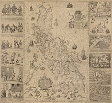
The Velarde map shows actual Philippine control over Scarborough Shoal,as well as islands off of Palawan,identified as the Spratly Islands. The map was one of the key evidences in the Philippines v. China international case that debunked China's so-called nine-dash line claims.The Spratlys labeled as "Los Bajos de Paragua" off the coast of Palawan (Paragua) on the 1734 Murillo Velarde map. Some shoals in the Spratlys were then considered part of Palawan in the Philippines v. China arbitration case.
Records show the islands as inhabited at various times in history by Chinese and Vietnamese fishermen. In 1888 the Central Borneo Company were granted a lease to work guano "on Sprattly island and Amboyna Cay"[37] During the Second World War troops from French Indochina and Japan were in occupation.[38][39][40] However,there is no record of large settlements on the islands until 1956,when Filipino adventurer Tomás Cloma,Sr.,decided to "claim" a part of Spratly islands as his own,naming it the "Free Territory of Freedomland".[41]
Evidence of human presence in the region extends back nearly 50,000 years at Tabon Caves on Palawan. Therefore,it is difficult to say when humans first came upon this island group. Within historical times,several groups may have passed through or occupied the islands. Between 600BC to 3BC there was an east to west migration by members of the seafaring Sa Huỳnh culture. This may have led them through the Spratly Islands on their way to Vietnam. These migrants were the forebears of the Cham people,an Austronesian-speaking people that founded the Old Champa empire that ruled what was known for centuries as the Champa Sea.[42][43]
Early records and cartography
Mao Kun map,Spratly Islands is suggested to be the islands at the bottom right (石星石塘;shíxīng shítáng). Others however believe the islands may refer to the Paracel Islands or Macclesfield Bank.
In the Song Dynasty work Zhu fan zhi by Zhao Rugua,the name "Thousand Li Stretch of Sands" (Qianli Changsha,千里長沙) and the "Ten-Thousand Li of Stone Pools/Beds" (Wanli Shitang萬里石塘,or Wanli Shichuang萬里石床) were given,interpreted by some to refer to Paracel and Spratly respectively.[47]Wanli Shitang is also recorded in the History of Yuan to have been explored by the Chinese during the Mongol-led Yuan dynasty and may have been considered by them to have been within their national boundaries.[48][49][50] However,the Yuan also ruled over Korea,Outer Mongolia,and parts of modern Russia. They are also referenced,sometimes with different names,in the Ming dynasty.[51][52] For example,in the Mao Kun map dating from Zheng He's voyage of the early 15th century,Shixing Shitang (石星石塘) is taken by some to mean Spratly,[44] however different authors interpret the identities of these islands differently.[45] Another Ming text,Haiyu (海語,On the Sea),uses Wanli Changsha (萬里長沙) for Spratly and noted that it is located southeast of Wanli Shitang (Paracels).[44] When the Ming Dynasty collapsed,the Qing dynasty continued to include the territory in maps compiled in 1724,[53] 1755,[54] 1767,[55] 1810,[56] and 1817,[57] but did not officially claim jurisdiction over these islands.
An 1801 Cary Map of the East Indies and Southeast Asia,with isles similar to those in the Mao Kun map. The isles are not the Paracels or Spratly Islands,but are instead identified as "Pulo Taya" and "Amphitrite".An 1838 Unified Dai Nam map marking Trường Sa and Hoàng Sa,which are considered as Spratly and Paracel Islands by some Vietnamese scholars;yet they share different latitude,location,shape and distance. The Paracel claim may have been correctly identified,however,the "Spratly" claim on the map may instead be islands nearer to Vietnamese shores,instead of the actual Spratly Islands.
A Vietnamese map from 1834 also combines the Spratly and Paracel Islands into one region known as "Vạn LýTrường Sa",a feature commonly incorporated into maps of the era (萬里長沙) ‒ that is, the same as the aforementioned Chinese island name Wanli Changsha.[58] According to Hanoi, Vietnamese maps record Bãi Cát Vàng (Golden Sandbanks, referring to both the Spratly and Paracel Islands), which lay near the coast of the central Vietnam, as early as 1838.[59] In Phủ Biên Tạp Lục (The Frontier Chronicles) by scholar Lê Quý Đôn, both Hoàng Sa and Trường Sa were defined as belonging to the Quảng Ngãi District. He described it as where sea products and shipwrecked cargoes were available to be collected. Vietnamese text written in the 17th century referenced government-sponsored economic activities during the Lê dynasty, 200years earlier. The Vietnamese government conducted several geographical surveys of the islands in the 18th century.[59]
A striking large black and white British chart of the sea in northern Borneo, first issued in 1881 and corrected to 1935.
Despite the fact that China and Vietnam both made a claim to these territories simultaneously, at the time, neither side was aware that its neighbour had already charted and made claims to the same stretch of islands.[59]
An early European map, A correct chart of the China Seas of 1758 by William Herbert, left the Spratly Islands region (known then as the Dangerous Ground) as largely blank, indicating that region has yet to be properly surveyed, although some islands and shoals at its western edge were marked (one appears at the same place as Thitu Island).[60][61] A number of maps of the South China Sea were later produced, but the first map that gives a reasonably accurate delineation of the Spratly Islands region (titled [South] China Sea, Sheet 1) was only published in 1821 by the hydrographer of the East India Company James Horsburgh after a survey by Captain Daniel Ross. A later 1859 edition of the map named the Spratly Island as Storm Island.[60] The islands were sporadically visited throughout the 19th and early 20th centuries by mariners from different European powers (including Richard Spratly, after whom the island group derives its most recognisable English name, who visited the group in the 1840s in his whalerCyrus).[62] However, these nations showed little interest in the islands. In 1883, German boats surveyed the Spratly and the Paracel Islands but eventually withdrew the survey, after receiving protests from the Guangdong government representing the Qing dynasty. China sent naval forces on inspection tours in 1902 and 1907 and placed flags and markers on the islands.[63]
In the 1950s, a group of individuals claimed sovereignty over the islands in the name of Morton F. Meads, supposedly an American descendant of a British naval captain who gave his name to Meads Island (Itu Aba) in the 1870s. In an affidavit made in 1971, the group claimed to represent the Kingdom of Humanity/Republic of Morac-Songhrati-Meads,[64] which they asserted was in turn the successor entity for a supposed Kingdom of Humanity established between the two world wars on Meads Island, allegedly by the son of the British captain. This claim to this would-be micronation fell dormant after 1972, when several members of the group drowned in a typhoon.[65][66][67][68]
In the 19th century, Europeans found that Chinese fishermen from Hainan annually sojourned on the Spratly islands for part of the year, while in 1877 it was the British who launched the first modern legal claims to the Spratly Islands.[71][72]
Chinese scholars and officials often try to claim that the 1887 Sino-French Tonkin Boundary convention signed between France and China after the Sino-French War recognised the sovereignty of China over of the Spratly and Paracel islands.[73] However, it is very clear that the Convention never mention a single word about Spratly and Paracel islands, nor South China Sea.[74] Professor Zou Keyuan, after examining carefully the text of the Convention, concluded that there was no mention of the Gulf of Tonkin and only part of the Gulf close to the land was shown on the attached map. Thus the representatives from both parties had no authorisation and/or intention to delimit the maritime boundary in the Gulf of Tonkin. A similar argument can be made with respect to a determination of sovereignty of the South China Sea islands. Chinese and French negotiators clearly did not have the authorisation or the intent to make such a determination in 1887.[75] France had already expressed the similar view in a diplomatic note dated back to October 10, 1937:
The provisions of the 1887 Treaty... had no other object but to fix the maritime frontier between China and Tonkin in the region of Monkai, attaching to China some territories and islands situated east of the mouth of the River Monkai and which were formerly under Annam. To simplify matters, the 105°43' Paris meridian was chosen as the demarcation line. However, the text of the agreement clearly shows that the clause at issue specifically refers to the Monkai region. To seek to apply it to the Paracels, which are situated almost 300 nautical miles south‐east, would amount to saying that everything east of the 105°43' meridian belongs to China. China could therefore lay claim to most of the coastal islands of Indochina, Poulo Condor among them! The absurd consequences of such an argument clearly show that only local scope and significance should be given to the clause in the 1887 Convention.[76]
The Chinese Ministry of Foreign Affairs also try to claim that a 1883 incident involving a German ship conducting surveys in the South China Sea without China's consent was protested with Berlin and the Germans terminated the survey.[63] Western scholars have determined, however, that this incident is not based on verifiable references and is inconsistent with other Chinese inaction during the same time period given that, in 1885, the German Admiralty published a two‐sheet chart entitled Die Paracel‐Inseln (The Paracel Islands). The chart documented the work of a German expedition to the Paracels between 1881 and 1884.[77]
Conflicts in the 20th century until 1945
China sent naval forces on inspection tours in 1902 and 1907 and placed flags and markers on the islands. The Qing dynasty's successor state, the Republic of China, claimed the Spratly and Paracel islands under the jurisdiction of Hainan.[63]
In 1933, France asserted its claims to the Spratly and Paracel Islands[citation needed] on behalf of its then-colony French Indochina.[78] It occupied a number of the Spratly Islands, including Taiping Island, built weather stations on two of the islands, and administered them as part of French Indochina. This occupation was protested by the Republic of China (ROC) government because France admitted finding Chinese fishermen there when French warships visited nine of the islands.[79] In 1935, the ROC government also announced a sovereignty claim on the Spratly Islands. Japan occupied some of the islands in 1939 during World War II, and it used the islands as a submarine base for the occupation of Southeast Asia. During the Japanese occupation, these islands were called Shinnan Shoto (新南諸島), literally the New Southern Islands, and together with the Paracel Islands (西沙群岛), they were put under the governance of the Japanese colonial authority in Taiwan.
Japan occupied the Paracels and the Spratly Islands from February 1939 to August 1945.[80] Japan annexed the Spratly Islands via Taiwan's jurisdiction and the Paracels via Hainan's jurisdiction.[71] Parts of the Paracels and Spratly Islands were again controlled by Republic of China after the 1945 surrender of Japan,[81] since the Allied powers assigned the Republic of China to receive Japanese surrenders in that area,[63] however no successor was named to the islands.[81]
In November 1946, the ROC sent naval ships to take control of the islands after the surrender of Japan.[80] It had chosen the largest and perhaps the only inhabitable island, Taiping Island, as its base, and it renamed the island under the name of the naval vessel as Taiping. Also following the defeat of Japan at the end of World War II, the ROC re-claimed the entirety of the Spratly Islands (including Taiping Island) after accepting the Japanese surrender of the islands based on the Cairo and Potsdam Declarations. The Republic of China then garrisoned Itu Aba (Taiping) island in 1946 and posted Chinese flags.[71] The aim of the Republic of China was to block the French claims.[63][82] The Republic of China drew up the map showing the U-shaped claim on the entire South China Sea, showing the Spratly and Paracels in Chinese territory, in 1947.[63] Japan had renounced all claims to the islands in the 1951 San Francisco Peace Treaty together with the Paracels, Pratas and other islands captured from the Chinese, and upon these declarations, the government of the Republic of China reasserted its claim to the islands. The Chinese Kuomintang force withdrew from most of the Spratly and Paracel Islands after they retreated to Taiwan from the opposing Chinese Communist Party due to their losses in the Chinese Civil War and the founding of the People's Republic of China (PRC) in 1949.[78] Taiwan quietly withdrew troops from Taiping Island in 1950, but then reinstated them in 1956 in response to Tomás Cloma's sudden claim to the island as part of Freedomland.[83]As of 2013[update], Taiping Island is administered by Taiwan.[84]
After pulling out its garrison in 1950 when the Republic of China evacuated to Taiwan, when the Filipino Tomas Cloma uprooted an ROC flag on Itu Aba laid claim to the Spratly Islands and, Taiwan again regarrisoned Itu Aba in 1956.[85] In 1946, the Americans allegedly reminded the Philippines at its independence that the Spratly Islands were not Philippine territory, both to not anger Chiang Kai-shek in China and because the Spratly Islands were not part of the Philippines per the 1898 treaty Spain signed with the United States.[71] However, no document was found to that effect. The Philippines then claimed the Spratly Islands in 1971 under President Marcos, after Taiwanese troops attacked and shot at a Philippine fishing boat on Itu Aba.[86]
Taiwan's garrison from 1946 to 1950 and 1956-now on Itu Aba represents an "effective occupation" of the Spratly Islands.[86][87] China established a coastal defence system against Japanese pirates or smugglers.[88]
In 1958, China issued a declaration defining its territorial waters that encompassed the Spratly Islands. North Vietnam's prime minister, Phạm Văn Đồng, sent a formal note to Zhou Enlai, stating that the Government of the Democratic Republic of Vietnam (DRV) respected the Chinese decision regarding the 12nmi (22km; 14mi) limit of territorial waters.[89] While accepting the 12-nmi principal with respect to territorial waters, the letter did not actually address the issue of defining actual territorial boundaries. North Vietnam recognised China's claims on the Paracels and Spratly Islands during the Vietnam War as it was being supported by China. Only after winning the war and conquering South Vietnam did North Vietnam retract its recognition and admitted it recognised them as part of China to receive aid from China in fighting the Americans.[90][91]
In 1987, China installed a small military structure on Fiery Cross Reef under the pretext of building an oceanic observation station and installing a tide gauge for the Global Sea Level Observing System.[92][verification needed] After a deadly skirmish with the Vietnamese Navy, China installed some military structures on more reefs in the vicinity of the Philippines and Vietnamese occupied islands and this led to escalating tensions between these countries and China over the status and ownership of reefs.
Under President Lee Teng-hui, Taiwan stated that "legally, historically, geographically, or in reality", all of the South China Sea and Spratly islands were Taiwan's territory and under Taiwanese sovereignty, and denounced actions undertaken there by Malaysia and the Philippines, in a statement on 13 July 1999 released by the foreign ministry of Taiwan.[94] Taiwan and China's claims "mirror" each other; during international talks involving the Spratly islands, China and Taiwan have cooperated with each other since both have the same claims.[86][95]
It was unclear whether France continued its claim to the islands after World War II, since none of the islands, other than Taiping Island, was habitable. The South Vietnamese government took over the Trường Sa administration after the defeat of the French at the end of the First Indochina War. "The French bestowed its titles, rights, and claims over the two island chains to the Republic of Vietnam (RoV) in accordance with the Geneva Accords", said Nguyen Hong Thao, Associate Professor at Faculty of Law, Vietnam National University.[96]
In 1999, a Philippine navy ship (Number 57 – BRP Sierra Madre) was purposely run aground near Second Thomas Shoal to enable establishment of an outpost. As of 2014[update] it had not been removed, and Filipino marines have been stationed aboard since the grounding.[97][98]
Conflicts in the 21st century
Taiwan and mainland China are largely strategically aligned on the Spratly islands issue, since they both claim exactly the same area, so Taiwan's control of Itu Aba (Taiping) island is viewed as an extension of China's claim.[73] Taiwan and China both claim the entire island chain, while all the other claimants only claim portions of them. China has proposed co-operation with Taiwan against all the other countries claiming the islands. Taiwanese lawmakers have demanded that Taiwan fortify Itu Aba (Taiping) island with weapons to defend against the Vietnamese, and both China and Taiwanese NGOs have pressured Taiwan to expand Taiwan's military capabilities on the island, which played a role in Taiwan expanding the island's runway in 2012.[99] China has urged Taiwan to co-operate and offered Taiwan a share in oil and gas resources while shutting out all the other rival claimants. Taiwanese lawmakers have complained about repeated Vietnamese aggression and trespassing on Taiwan's Itu Aba (Taiping), and Taiwan has started viewing Vietnam as an enemy over the Spratly Islands, not China.[100] Taiwan's state run oil company CPC Corporation's board director Chiu Yi has called Vietnam as the "greatest threat" to Taiwan.[99] Taiwan's airstrip on Taiping has irritated Vietnam.[101] China views Taiwan's expansion of its military and airstrip on Taiping as benefiting China's position against the other rival claimants from southeast Asian countries.[87] China's claims to the Spratly Islands benefit from legal weight because of Taiwan's presence on Itu Aba, while America on the other hand has regularly ignored Taiwan's claims in the South China Sea and does not include Taiwan in any talks on dispute resolution for the area.[102]
Taiwan performed live fire military exercises on Taiping island in September 2012; reports said that Vietnam was explicitly named by the Taiwanese military as the "imaginary enemy" in the drill. Vietnam protested against the exercises as violation of its territory and "voiced anger", demanding that Taiwan stop the drill. Among the inspectors of the live fire drill were Taiwanese national legislators, adding to the tensions.[103]
In May 2011, Chinese patrol boats attacked two Vietnamese oil exploration ships near the Spratly Islands.[citation needed] Also in May 2011, Chinese naval vessels opened fire on Vietnamese fishing vessels operating off East London Reef (Da Dong). The three Chinese military vessels were numbered 989, 27 and 28, and they showed up with a small group of Chinese fishing vessels. Another Vietnamese fishing vessel was fired on near Fiery Cross Reef (Chu Thap). The Chief Commander of Border Guards in Phú Yên Province, Vietnam, reported that a total of four Vietnamese vessels were fired upon by Chinese naval vessels.[104][failed verification] These incidents involving Chinese forces sparked mass protests in Vietnam, especially in Hanoi and Ho Chi Minh City,[105] and in various Vietnamese communities in the West (namely in the US state of California and in Paris) over attacks on Vietnamese citizens and the intrusion into what Vietnam claimed was part of its territory.[106]
In June 2011, the Philippines began officially referring to parts of the South China Sea as the "West Philippine Sea" and the Reed Bank as "Recto Bank".[107][108]
In 2010, it was reported that the former Malaysian Prime Minister Mahathir Mohamad believed Malaysia could profit from China's economic growth through co-operation with China,[111] and said that China "was not a threat to anyone and was not worried about aggression from China", as well accusing the United States of provoking China and trying to turn China's neighbours against China.[112] Malaysian authorities displayed no concern over China conducting a military exercise at James Shoal in March 2013,[33] with its Defence MinisterHishammuddin Hussein suggested they might work with China and saying that Malaysia had no problem with China patrolling the South China Sea, and telling ASEAN, America, and Japan that "Just because you have enemies, doesn't mean your enemies are my enemies".[113] However, until present Malaysia still maintained a balance relations with the countries involved in this dispute.[114] But since China has started encroaching its territorial waters,[115] Malaysia has become active in condemning China.[116][117]
The editorial of the Taiwanese news website Want China Times accused America of being behind the May 2014 flareup in the South China Sea, saying that Vietnam rammed a Chinese vessel on 2 May over an oil rig drilling platform and the Philippines detained 11 Chinese fishermens occurred because of Obama's visit to the region and that they were incited by America "behind the scenes". Want China Times claimed America ordered Vietnam on 7 May to complain about the drilling platform, and noted that a joint military exercise was happening at this time between the Philippines and America, and also noted that the American New York Times newspaper supported Vietnam.[118]
In a series of news stories on 16 April 2015, it was revealed, through photos taken by Airbus, that China had been building an airstrip on Fiery Cross Reef, one of the southern islands. The 10,000-foot-long (3,048m) runway covers a significant portion of the island, and is viewed as a possible strategic threat to other countries with claims to the islands, such as Vietnam and the Philippines.
Champa historically had a large presence in the South China Sea. The Vietnamese broke Champa's power in an invasion of Champa in 1471, and then finally conquered the last remnants of the Cham people in an invasion in 1832. A Cham named Katip Suma who received Islamic education in Kelantan declared a Jihad against the Vietnamese, and fighting continued until the Vietnamese crushed the remnants of the resistance in 1835. The Cham organisation Front de Libération du Champa was part of the United Front for the Liberation of Oppressed Races, which waged war against the Vietnamese for independence in the Vietnam War along with the Montagnard and Khmer Krom minorities. The last remaining FULRO insurgents surrendered to the United Nations in 1992.
The Vietnamese government fears that evidence of Champa's influence over the disputed area in the South China Sea would bring attention to human rights violations and killings of ethnic minorities in Vietnam such as in the 2001 and 2004 uprisings, and lead to the issue of Cham autonomy being brought into the dispute, since the Vietnamese conquered the Hindu and Muslim Cham people in a war in 1832.[119]
Japanese scholar Taoka Shunji said in a journal article that the assumption amongst many Japanese people that the territory of the Philippines was being invaded by China, was incorrect. He pointed out that the Spratly islands were not part of the Philippines, when the US acquired the Philippines from Spain in the Treaty of Paris in 1898, and when the Japanese-ruled Taiwan itself had annexed the Spratly islands in 1938, the US-ruled Philippines did not challenge the move and never asserted that it was their territory. He also pointed out that other countries did not need to do full land reclamation since they already control islands, and that the reason China engaged in extensive land reclamation is because they needed it to build airfields since China only has control over reefs.[120]
The "Moro" as "people", is used to describe both the Filipino Muslims and their homeland. Ancestors of Moro people were the owners of Spratly Islands prior to the arrival of the Spanish colonials in the 16th century, according to the Sultan of Sulu in the southern Philippines reported in a local paper. "China has no right over the Spratly Islands in what it calls the South China Sea because that is part of our ancestral domain," Majaraj Julmuner Jannaral, Sultanate information officer, told the Philippine Star. "The Spratly Archipelago is part of the Sulu Sea (the inner area around the islands in the southern Philippines, which is part of the West Philippine Sea (designation of parts of the South China Sea claimed by the Philippines to be part of its EEZ)," Jannaral concluded. "Exploration of the marine territory and the waters around the Spratly Archipelago, Palawan in southwestern Philippines and the southern Philippines, belong to the residents in those areas," he added. The Sultanate of Sulu claims historic proprietary rights over the Spratly Islands since before the Spanish colonial era.[121]
Various incidents of fishing boats being harassed by Chinese warships have occurred.[122][123][124] At least 2 vessels were rammed or sunk. One was a Vietnamese ship attacked by a Chinese coastguard vessel, and another was a Fillipino ship rammed and sunk by a Chinese fishing boat who let the Fillipino fishermen drift at sea without giving aid. The stranded fishermen were later rescued by a Vietnamese ship.[125][126]
In 2017, the United States despite not being a claimant in the Spratly dispute, reported using freedom of navigation operations (FONOPs) to challenge what it deemed as excessive and illegal maritime claims from multiple Asia-Pacific states including Cambodia, China, India, Indonesia, Malaysia, Maldives, the Philippines, Sri Lanka, Taiwan, and Vietnam.[127]
In 2022, Vietnam demanded that Taiwan cease conducting live fire exercises at the Spratly Islands.[128]
On 12 July 2016, the arbitral tribunal ruled in favor of the Philippines on most of its submissions. While it would not "rule on any question of sovereignty over land territory and would not delimit any maritime boundary between the Parties", it concluded that China had not historically exercised exclusive control within the nine-dash line, hence has "no legal basis" to claim "historic rights" to resources.[129] It also concluded that China's historic rights claims over the maritime areas (as opposed to land masses and territorial waters) inside the nine-dash line would have no lawful effect outside of what is entitled to under UNCLOS.[133][134][135] It criticized China's land reclamation projects and construction of artificial islands in the Spratly Islands, saying that they had caused "severe harm to the coral reef environment".[136] Finally, it characterized Taiping Island and other features of the Spratly Islands as "rocks" under UNCLOS, and therefore are not entitled to a 200 nautical mile exclusive economic zone.[137] The award was ruled as final and non-appealable by either country.[138][139] China rejected the ruling, calling it "ill-founded".[140] Taiwan, which currently administers Taiping Island, the largest of the Spratly Islands, also rejected the ruling.[141] Eight governments have publicly called for the ruling to be respected, 35 have issued generally positive statements without calling for parties to abide by it, and eight have publicly rejected it. The eight governments in support were Australia, Canada, Germany, Japan, New Zealand, the Philippines, United Kingdom, and the United States; the eight in opposition were China, Montenegro, Pakistan, Russia, Sudan, Syria, Taiwan, and Vanuatu.[142][143] The United Nations itself does not have a position on the legal and procedural merits of the case or on the disputed claims, and the Secretary-General expressed his hope that the continued consultations on a Code of Conduct between ASEAN and China under the framework of the Declaration of the Conduct of Parties in the South China Sea will lead to increased mutual understanding among all the parties.[144]
Vietnam Military Telecommunications Corp., known commonly as Viettel, established mobile coverage in the Spratly Islands in 2007.[149]
On 18 May 2011, China Mobile announced that its mobile phone coverage has expanded to the Spratly Islands. The extended coverage would allow soldiers stationed on the islands, fishermen, and merchant vessels within the area to use mobile services, and can also provide assistance during storms and sea rescues. The service network deployment over the islands took nearly one year.[150]
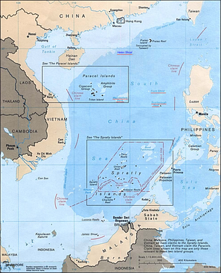
The Paracel Islands, also known as the Xisha Islands and the Hoàng Sa Archipelago, are a disputed archipelago in the South China Sea.
The South China Sea is a marginal sea of the Western Pacific Ocean. It is bounded in the north by South China, in the west by the Indochinese Peninsula, in the east by the islands of Taiwan and northwestern Philippines, and in the south by the Indonesian islands of Borneo, eastern Sumatra and the Bangka Belitung Islands, encompassing an area of around 3,500,000 km2 (1,400,000 sq mi). It communicates with the East China Sea via the Taiwan Strait, the Philippine Sea via the Luzon Strait, the Sulu Sea via the straits around Palawan, and the Java Sea via the Karimata and Bangka Straits. The Gulf of Thailand and the Gulf of Tonkin are part of the South China Sea.
The South China Sea Islands consist of over 250 islands, atolls, cays, shoals, reefs and seamounts in the South China Sea. The islands are mostly low and small and have few inhabitants. The islands and surrounding seas are subject to overlapping territorial claims by the countries bordering the South China Sea.
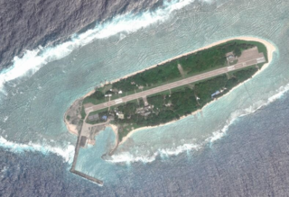
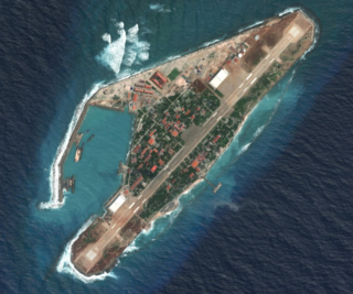
Taiping Island, also known as Itu Aba, and various other names, is the largest of the naturally occurring Spratly Islands in the South China Sea. The island is elliptical in shape being 1.4 kilometres (0.87 mi) in length and 0.4 kilometres (0.25 mi) in width, with an area of 46 hectares. It is located on the northern edge of the Tizard Bank. The runway of the Taiping Island Airport is easily the most prominent feature on the island, running its entire length.
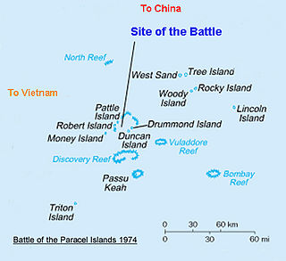
The Battle of the Paracel Islands was a military engagement between the naval forces of China and South Vietnam in the Paracel Islands on January 19, 1974. The battle was an attempt by the South Vietnamese navy to expel the Chinese navy from the vicinity. The confrontation took place towards the end of the Vietnam War.
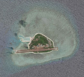
Thitu Island, also known as Đảo Thị Tứ, Pag-asa Island and Zhongye Dao, having an area of 37.2 hectares, is the second largest of the naturally occurring island in Spratly Islands. It lies about 500 kilometers (310 mi) west of Puerto Princesa. Its neighbors are the North Danger Reef to the north, Subi Reef to the west, and the Loaita and Tizard Banks to the south.
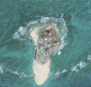
The Johnson South Reef skirmish took place on 14 March 1988 between military forces of the People's Republic of China and Vietnam, on the Johnson South Reef in the Union Banks region of the Spratly Islands, in the South China Sea. Accounts of the event are disputed. Both sides agree that multiple military personal were killed, that Vietnam suffered more casualties than China, and that China occupied the island.
Sansha City is a prefecture-level city under the Hainan province of the People's Republic of China (PRC), and is the southernmost and least populated prefecture in China, with the smallest land area but the largest maritime territory. The city's seat is located on Yongxing Island in the South China Sea, and administers several island groups, atolls, seamounts and a number of other ungrouped maritime features within the nine-dash line, although the PRC's de facto control over the area varies. The name "Sansha", literally meaning "three sands", refers to the three archipelago districts of Xisha, Zhongsha and Nansha.
Philippines and the Spratly Islands – this article discusses the policies, activities and history of the Republic of the Philippines in the Spratly Islands from the Philippine perspective. Non-Philippine viewpoints regarding Philippine occupation of several islands are currently not included in this article.
Spratly Island,, also known as Storm Island, is the fourth largest of the naturally occurring Spratly Islands in the South China Sea with an area of 15 hectares, and the largest of the Vietnamese-administered Spratly islands.
Amboyna Cay, also known as Vietnamese: Đảo An Bang; Malay: Pulau Amboyna Kecil; Datu Kalantiaw Island ; Mandarin Chinese: 安波沙洲; pinyin: Ānbō Shāzhōu, and other names, is an island of the Spratly Islands group in the South China Sea located just outside (SW) of the southwest of Dangerous Ground. It is SW of Barque Canada Reef, south of the London Reefs, and NW of Swallow Reef.
Malaysia and Vietnam are two Southeast Asian countries with maritime boundaries which meet in the Gulf of Thailand and South China Sea. The two countries have overlapping claims over the continental shelf in the Gulf of Thailand. Both countries have, however, come to an agreement to jointly exploit the natural resources in the disputed area pending resolution of the dispute over sovereignty.
The Spratly Islands dispute is an ongoing territorial dispute between Brunei, China, Malaysia, the Philippines, Taiwan, and Vietnam concerning "ownership" of the Spratly Islands, a group of islands and associated "maritime features" located in the South China Sea. The dispute is characterized by diplomatic stalemate and the employment of military pressure techniques in the advancement of national territorial claims. All except Brunei occupy some of the maritime features.
The nine-dash line, also referred to as the eleven-dash line by Taiwan, is a set of line segments on various maps that accompanied the claims of the People's Republic of China and the Republic of China in the South China Sea. The contested area includes the Paracel Islands, the Spratly Islands, the Pratas Island and the Vereker Banks, the Macclesfield Bank, and the Scarborough Shoal. Certain places have undergone land reclamation by the PRC, ROC, and Vietnam. The People's Daily of the PRC uses the term Duànxùxiàn (断续线) or Nánhǎi Duànxùxiàn, while the ROC government uses the term Shíyīduàn xiàn.
Territorial disputes in the South China Sea involve conflicting island and maritime claims in the South China Sea by several sovereign states, namely the People's Republic of China (PRC), Taiwan, Brunei, Malaysia, the Philippines, and Vietnam. The disputes involve the islands, reefs, banks, and other features of the region, including the Spratly Islands, Paracel Islands, Scarborough Shoal, and various boundaries in the Gulf of Tonkin. The waters near the Indonesian Natuna Islands, which some regard as geographically part of the South China Sea, are disputed as well. Maritime disputes also extend beyond the South China Sea, as in the case of the Senkaku Islands and the Socotra Rock, which lie in the East China Sea.
The South China Sea Arbitration was an arbitration case brought by the Republic of the Philippines against the People's Republic of China (PRC) under Annex VII of the United Nations Convention on the Law of the Sea concerning certain issues in the South China Sea, including the nine-dash line introduced by the mainland-based Republic of China since as early as 1947. A tribunal of arbitrators appointed the Permanent Court of Arbitration (PCA) as the registry for the proceedings.
The Hai Yang Shi You 981 standoff, also known as the 2014 China-Vietnam oil rig crisis, refers to the tensions between China and Vietnam arising from the Chinese state-owned China National Offshore Oil Corporation moving its Hai Yang Shi You 981 oil platform to waters near the disputed Paracel Islands in South China Sea, and the resulting Vietnamese efforts to prevent the platform from establishing a fixed position. According to an announcement by the Hainan Maritime Safety Administration of China, the drilling work of the Hai Yang Shi You 981 would last from May 2 to August 15, 2014. On July 15, China announced that the platform had completed its work and withdrew it fully one month earlier than originally announced.
The article covers events that are related to the South China Sea dispute. In the South China Sea, historically China, Japan and France have disputed over Spratly and Paracel Islands. Presently, the Paracel Islands are disputed among China (PRC), Taiwan (ROC), and Vietnam, while Pratas Island is contested between China and Taiwan. Additionally, the Spratly Islands are subject to intertwined claims by China, Taiwan, Vietnam, the Philippines, Malaysia, and Brunei. Because of this, numerous countries with territorial disputes have had conflicts in the South China Sea since the past.
Vietnam claims an exclusive economic zone (EEZ) of 1,395,096 km2 (538,650 sq mi) with 200 nautical miles from its shores.
References
Notes
↑ Black type is used for islands, and for those reefs and shoals that have portions above water at high tide. Blue type is used for submerged features. Erratum: Hughes Reef is wrongly labelled Chigua Reef, a name of Johnson South Reef in Chinese, part of the same Union Banks sunken atoll.
1 2 Hutchison, C. S., and V. R. Vijayan, 2010, What are the Spratly Islands? Journal of Asian Earth Science. vol. 39, no. 5, pp. 371–385.
1 2 Wei-Weil, D., and L, Jia-Biao, 2011, Seismic Stratigraphy, Tectonic Structure and Extension Factors Across the Dangerous Grounds: Evidence from Two Regional Multi-Channel Seismic Profiles. Chinese Journal of Geophysics. vol. 54, no. 6, pp. 921–941.
1 2 Zhen, S., Z. Zhong-Xian, L. Jia-Biao, Z. Di, and W. Zhang-Wen, 2013, Tectonic Analysis of the Breakup and Collision Unconformities in the Nansha Block. Chinese Journal of Geophysics. vol. 54, no. 6, pp. 1069–1083.
↑ Blanche, J. B. and J. D. Blanche, 1997, An Overview of the Hydrocarbon Potential of the Spratly Islands Archipelago and its Implications for Regional Development. in A. J. Fraser, S. J. Matthews, and R. W. Murphy, eds., pp. 293–310, Petroleum Geology of South East Asia. Special Publication no. 126, The Geological Society, Bath, England 436 pp.
↑ "FO 881/5741". Archived from the original on 20 February 2020. Retrieved 20 February 2020.
↑ "Timeline". History of the Spratlys. www.spratlys.org. Archived from the original on 21 March 2014. Retrieved 21 March 2014.
↑ Chemillier-Gendreau, Monique (2000). Sovereignty Over the Paracel and Spratly Islands. Kluwer Law International. ISBN978-90-411-1381-8.
↑ China Sea pilot. Vol.1 (8thed.). Taunton: UKHO – United Kingdom Hydrographic Office. 2010. Archived from the original on 21 March 2014. Retrieved 21 March 2014.
1 2 David Hancox and Victor Prescott (1995). "A Geographical Description of the Spratly Islands and an Account of Hydrographic Surveys Amongst Those Islands". Maritime Briefing. 1 (6): 31–32.
↑ MARITIME BRIEFING, Volume I, Number 6: A Geographical Description of the Spratly Island and an Account of Hydrographic Surveys Amongst Those Islands, 1995 by David Hancox and Victor Prescott. Pages 14–15
↑ Whiting, Kenneth (2 February 1992). "Asian Nations Squabble Over Obscure String of Islands". Los Angeles Times. p.A2.
↑ Borneo Post: When All Else Fails(archived from the original on 28 February 2008) Additionally, pages 48 and 51 of "The Brunei-Malaysia Dispute over Territorial and Maritime Claims in International Law" by R. Haller-Trost, Clive Schofield, and Martin Pratt, published by the International Boundaries Research UnitArchived 18 October 2009 at the Wayback Machine , University of Durham, UK, points out that this is, in fact, a "territorial dispute" between Brunei and other claimants over the ownership of one above-water feature (Louisa Reef)
↑ Chemillier-Gendreau, Monique (2000). Sovereignty over the Paracel and Spratly Islands. The Hague, The Netherlands: Brill/Martinus Nijhoff Publishers. p.99. ISBN978-90-411-1381-8.
↑ Himmelman, Jeff; Gilbertson, Ashley (24 October 2013). "A game of shark and minnow". The New York Times. Archived from the original on 27 August 2017. Retrieved 17 March 2014.
↑ Lee, Peter (29 July 2010). "US goes fishing for trouble". Asia Times Online. p.2. Archived from the original on 17 May 2014. Retrieved 14 May 2014.{{cite news}}: CS1 maint: unfit URL (link)
Carpenter, Ted Galen (28 February 2013). "Taiwan Challenges Its Neighbors". The National Interest. Archived from the original on 17 May 2014. Retrieved 10 March 2014.
Carpenter, Ted Galen (28 February 2013). "Taiwan Challenges Its Neighbors". The National Interest. Cato Institute. Archived from the original on 17 May 2014. Retrieved 10 March 2014.
Carpenter, Ted Galen (4 March 2013). "Taiwan Challenges Its Neighbors". Real Clear Politics. Cato Institute. Archived from the original on 17 May 2014. Retrieved 10 March 2014.
Carpenter, Ted Galen (28 February 2013). "Taiwan Challenges Its Neighbors". LibertyVoter.org. Archived from the original on 6 October 2014. Retrieved 10 March 2014.
↑ Vu, Minh (12 March 2022). "Vietnam demands Taiwan cancel military drills in Spratlys". hanoitimes.vn. Retrieved 22 March 2022. 'The fact that Taiwan continues to hold live-fire drills in the waters around Ba Binh in Vietnam's Truong Sa Islands is a serious violation of Vietnam's sovereignty over these islands, threatening peace, maritime stability, safety and security, causing tension, and complicating the situation in the East Sea (referring to the South China Sea),' Spokesperson Le Thi Thu Hang said Friday
This page is based on this Wikipedia article Text is available under the CC BY-SA 4.0 license; additional terms may apply. Images, videos and audio are available under their respective licenses.