A toll road, also known as a turnpike or tollway, is a public or private road for which a fee is assessed for passage. It is a form of road pricing typically implemented to help recoup the cost of road construction and maintenance.
Springfield is a census-designated place (CDP) in northwestern Hampshire County in the U.S. state of West Virginia. As of the 2010 census, Springfield had a population of 477. Springfield is located north of Romney along West Virginia Route 28 at its junction with Green Spring Road and Springfield Pike. It is currently considering incorporation.
Capon Bridge is a town in eastern Hampshire County, West Virginia, United States, along the Northwestern Turnpike, approximately 20 miles (32 km) west of Winchester, Virginia. The population was 355 at the 2010 census. Originally known as "Glencoe", Capon Bridge was incorporated in 1902 by the Hampshire County Circuit Court. It is named because of the construction of the bridge over the Cacapon River at that place, the name of the river being derived from the Shawnee Cape-cape-de-hon, meaning "river of medicine water".
Springfield Grade Road was originally known as the Great Wagon Road or Great Wagon Turnpike that connected Winchester, Virginia to Cumberland, Maryland in the late 18th and early 19th centuries. Later, in the 18th century, the wagon road became known as the Springfield Grade and when county routes were established in West Virginia in the 1920s, the road was signed as Springfield Grade Road. From Springfield to Slanesville on West Virginia Route 29 (then West Virginia Route 45), Springfield Grade was County Route 3. From Slanesville to the village of North River Mills, the grade was County Route 45/20. And finally, from North River Mills to Capon Bridge, the grade was County Route 15.
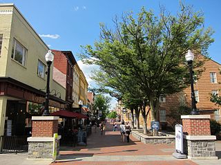
Winchester is an independent city located in the northwestern portion of the Commonwealth of Virginia in the United States. As of the 2010 census, the population was 26,203. As of 2015, its population is an estimated 27,284. It is the county seat of Frederick County, although the two are separate jurisdictions. The Bureau of Economic Analysis combines the city of Winchester with surrounding Frederick County for statistical purposes.
Virginia, officially the Commonwealth of Virginia, is a state in the Southeastern and Mid-Atlantic regions of the United States located between the Atlantic Coast and the Appalachian Mountains. Virginia is nicknamed the "Old Dominion" due to its status as the first English colonial possession established in mainland North America and "Mother of Presidents" because eight U.S. presidents were born there, more than any other state. The geography and climate of the Commonwealth are shaped by the Blue Ridge Mountains and the Chesapeake Bay, which provide habitat for much of its flora and fauna. The capital of the Commonwealth is Richmond; Virginia Beach is the most populous city, and Fairfax County is the most populous political subdivision. The Commonwealth's estimated population as of 2017 is over 8.4 million.
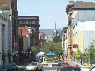
Cumberland is a city in and the county seat of Allegany County, Maryland, United States. It is the primary city of the Cumberland, MD-WV Metropolitan Statistical Area. At the 2010 census, the city had a population of 20,859, and the metropolitan area had a population of 103,299. Located on the Potomac River, Cumberland is a regional business and commercial center for Western Maryland and the Potomac Highlands of West Virginia.
In 2003, the Hampshire County 911 Center was given the responsibility of completing a database of Hampshire County roadnames to ensure that there were no duplicate names that would interfere with emergency services and the county's new addressing system. It was decided that because Springfield Grade Road was made up of several Secondary Routes, it would be divided and renamed. On the section of Secondary Route 3 between Springfield and Points, the grade was renamed Springfield Pike. The remainder of County Route 3 between Points and Slanesville was renamed Slanesville Pike. County Routes 45/20 and 15 were renamed Cold Stream Road between Slanesville and Capon Bridge.
Today, while the newly assigned addresses to the residents living on the old Springfield Grade Road reflect the road's newly minted names, the people of Hampshire County continue to refer to it as Springfield Grade.
This page is based on this Wikipedia article Text is available under the CC BY-SA 4.0 license; additional terms may apply. Images, videos and audio are available under their respective licenses.
Related Research Articles
Hampshire County is a county in the U.S. state of West Virginia. As of the 2010 census, the population was 23,964. Its county seat is Romney, West Virginia's oldest town (1762). The county was created by the Virginia General Assembly in 1754, from parts of Frederick and Augusta Counties (Virginia) and is the state's oldest county. The county lies in both West Virginia's Eastern Panhandle and Potomac Highlands regions.
The Cacapon River, located in the Appalachian Mountains of West Virginia's Eastern Panhandle region, is an 81.0-mile-long (130.4 km) river known for its fishing, boating, wildlife, and scenery. As part of the Potomac River watershed, it is an American Heritage River.
The Northwestern Turnpike is a historic road in West Virginia, important for being historically one of the major roads crossing the Appalachians, financed by the Virginia Board of Public Works in the 1830s. In modern times, west of Winchester, Virginia, U.S. Route 50 follows the path of the Northwestern Turnpike into West Virginia, whose major Corridor D project follows the western section of the original Northwestern Turnpike.
North River Mills is a historic unincorporated community in Hampshire County in the U.S. state of West Virginia. North River Mills is located between Capon Bridge and Slanesville on Cold Stream Road at its intersection with North River Road. The village of North River Mills lies along the eastern banks of North River from which it takes its name.
Slanesville is an unincorporated community in northeastern Hampshire County in the U.S. state of West Virginia. Slanesville is located at the crossroads of Bloomery Pike with Slanesville Pike and Cold Stream Road. Slanesville Pike and Cold Stream Road formerly made up the Springfield Grade Road that ran from Capon Bridge to Springfield. According to the 2000 census, the Slanesville community has a population of 691.
Points is an unincorporated community in Hampshire County in the U.S. state of West Virginia. According to the 2000 census, the Points community has a population of 478.
Millesons Mill is an unincorporated community hamlet in Hampshire County, West Virginia, United States. Millesons Mill is located between Springfield and Points on Springfield Pike along the South Branch Potomac River. Milleson Road meets Springfield Pike in Millesons Mill.
Hooks Mills is an unincorporated community in Hampshire County, West Virginia, United States. It is located on Hooks Mill Road which intersects Cacapon River Road 4.5 miles south of Capon Bridge. Hooks Mills is named for the saw and grist mill on the Cacapon River run by the Hook family from 1848 to the late 1930s.
The Winchester and Western Railroad is a shortline railroad operating from Gore through Winchester, Virginia and West Virginia to Hagerstown, Maryland. It also operates several lines in southern New Jersey, connecting to Conrail Shared Assets Operations at Millville and Vineland.
The Bloomery Pike is a north/south named route that runs from the North Frederick Pike in Frederick County, Virginia, United States to the Northwestern Turnpike near Augusta in Hampshire County, West Virginia. The Bloomery Pike was named for the community of Bloomery and the bloomeries that operated there.
Hoy is an unincorporated community in Hampshire County in the U.S. state of West Virginia. It is located southwest of Slanesville and northwest of Hanging Rock at the intersection of Offutt School Road and Hoy Road. A series of hills separates the community from the North River which lies to its east. Hoy once operated its own post office and elementary school before consolidation of both with Slanesville.
Hampshire County Schools is the operating school district within Hampshire County, West Virginia. It is governed by the Hampshire County Board of Education.
Bear Garden Mountain is a forested mountain ridge of the Ridge-and-valley Appalachians in Hampshire County, West Virginia and Frederick County, Virginia.
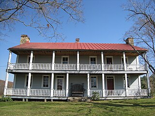
Hook Tavern is a late 18th-century tavern along the Northwestern Turnpike east of Capon Bridge in Hampshire County, West Virginia. It was listed on the National Register of Historic Places on April 29, 2011.
The Capon and North Branch Turnpike was a 19th-century turnpike in Hampshire County in the U.S. state of Virginia. The turnpike facilitated increased communication and transportation between Cumberland, Maryland and Winchester, Virginia via the Northwestern Turnpike in Capon Bridge, West Virginia. As of July 2010, the Capon and North Branch Turnpike's original route is made up of segments of West Virginia Route 28, Springfield Pike, Slanesville Pike, and Cold Stream Road.
The North River is a tributary of the Cacapon River, belonging to the Potomac River and Chesapeake Bay watersheds. The river is located in Hampshire and Hardy counties in the U.S. state of West Virginia's Eastern Panhandle. The mouth of the North River into the Cacapon is located at Forks of Cacapon. From its headwaters to its mouth, the North River spans 52.4 miles (84.3 km) in length.
James Caudy was an American frontiersman, settler, and landowner in the Ridge-and-Valley Appalachians of the Colony of Virginia—present-day West Virginia. Caudy was born in the Netherlands, immigrated to the Thirteen Colonies in the 1730s, and settled within the Cacapon River valley near present-day Capon Bridge in Hampshire County. As early as 1741, Caudy was associated with the arrangement and development of transportation routes throughout present-day Hampshire County. Caudy twice hosted George Washington; first during his surveying expedition in 1748 and again upon Washington's 1750 return to the Cacapon River valley.
The Capon Lake Whipple Truss Bridge, formerly known as South Branch Bridge or Romney Bridge, is a historic Whipple truss bridge in Capon Lake, West Virginia. It is located off Carpers Pike and crosses the Cacapon River. The bridge formerly carried Capon Springs Road over the river, connecting Capon Springs and Capon Lake.