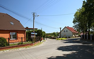
Potulice is a village in the administrative district of Gmina Nakło nad Notecią, within Nakło County, Kuyavian-Pomeranian Voivodeship, in north-central Poland. It lies approximately 7 kilometres (4 mi) south-east of Nakło nad Notecią and 22 km (14 mi) west of Bydgoszcz. It is best known as the site of the World War II Potulice concentration camp, also known as Lebrechtsdorf.

Yelverton Lodge is an 18th-century hunting lodge in Twickenham in the London Borough of Richmond upon Thames. Situated opposite Marble Hill Park and Marble Hill House, it was acquired for Henrietta Howard, Countess of Suffolk, later Countess of Suffolk and one time mistress of King George II.

Bảo Lộc is a city of Lâm Đồng Province in the Central Highlands region of Vietnam. Bảo Lộc is famous for its registered trademark: B'lao tea. As of 2003 the town district had a population of 151,915. The district covers an area of 229 km². The district capital lies at Bảo Lộc.

Brąchnówko is a village in the administrative district of Gmina Chełmża, within Toruń County, Kuyavian-Pomeranian Voivodeship, in north-central Poland. It lies approximately 7 kilometres (4 mi) south of Chełmża and 14 km (9 mi) north of Toruń.
Błądzim-Dworzec is a village in the administrative district of Gmina Cekcyn, within Tuchola County, Kuyavian-Pomeranian Voivodeship, in north-central Poland.
Lubiewice is a village in the administrative district of Gmina Cekcyn, within Tuchola County, Kuyavian-Pomeranian Voivodeship, in north-central Poland.
Małe Budziska is a village in the administrative district of Gmina Cekcyn, within Tuchola County, Kuyavian-Pomeranian Voivodeship, in north-central Poland.
Wierzchlas is a village in the administrative district of Gmina Cekcyn, within Tuchola County, Kuyavian-Pomeranian Voivodeship, in north-central Poland.
Wysoka is a village in the administrative district of Gmina Cekcyn, within Tuchola County, Kuyavian-Pomeranian Voivodeship, in north-central Poland.
Ligota Czamborowa is a village in the administrative district of Gmina Izbicko, within Strzelce County, Opole Voivodeship, in south-western Poland.
Bagna is a settlement in the administrative district of Gmina Czersk, within Chojnice County, Pomeranian Voivodeship, in northern Poland.
Łąg-Kolonia is a village in the administrative district of Gmina Czersk, within Chojnice County, Pomeranian Voivodeship, in northern Poland.
Szyszkowiec is a settlement in the administrative district of Gmina Czersk, within Chojnice County, Pomeranian Voivodeship, in northern Poland.
Uroża is a settlement in the administrative district of Gmina Czersk, within Chojnice County, Pomeranian Voivodeship, in northern Poland.
Ustronie is a settlement in the administrative district of Gmina Czersk, within Chojnice County, Pomeranian Voivodeship, in northern Poland.

Odry is a village in the administrative district of Gmina Czersk, within Chojnice County, Pomeranian Voivodeship, in northern Poland. It lies approximately 12 kilometres (7 mi) north of Czersk, 38 km (24 mi) north-east of Chojnice, and 67 km (42 mi) south-west of the regional capital Gdańsk.

The New Castle in Hrodna, Belarus is a royal palace of Augustus III of Poland and Stanisław August Poniatowski where the famous Grodno Sejm took place in 1793. New Hrodna Castle is 116 metres (381 ft) above sea level.

Gotanno Station is a railway station on the Tobu Skytree Line in Adachi, Tokyo, Japan, operated by the private railway operator Tobu Railway.
Townley Hall is a Georgian country house which stands in parkland at Tullyallen some 5 km west of Drogheda, County Louth in the Republic of Ireland. It was designed by Irish architect Francis Johnston for the Townley Balfour family and built between 1794 and 1798.

Katangi railway station is a railway station in Katangi block of Balaghat district in Madhya Pradesh, India. It is on a broad-gauge network, in the South East Central Railway zone. It is connected with Waraseoni, Balaghat, and Gondia. The DEMU train runs between these stations.


