The Meža (Slovene) or Mieß (German) is a river in the Austrian state of Carinthia and in Slovenia, a right tributary of the Drava. It is 43 km long, of which 42 km in Slovenia. Its catchment area is 551.7 km2, of which 543 km2 in Slovenia.

Mislinja is a settlement in northern Slovenia. It is the seat of the Municipality of Mislinja. It lies in the valley of the Mislinja River. The area traditionally belonged to Styria. In 1995 it became part of the newly formed Carinthia Statistical Region.

Rogatec is a small town in eastern Slovenia, on the border with Croatia. It is the seat of the Municipality of Rogatec. The area traditionally belonged to the region of Styria. It is now included in the Savinja Statistical Region.

Mislinjska Dobrava is a settlement in the City Municipality of Slovenj Gradec in northern Slovenia. It lies in the Mislinja Valley southeast of the town of Slovenj Gradec. The area was traditionally part of Styria. The entire municipality is now included in the Carinthia Statistical Region.
Stari Trg is a settlement in the City Municipality of Slovenj Gradec in northern Slovenia. The area was traditionally part of Styria. The entire municipality is now included in the Carinthia Statistical Region.
Gradišče is a settlement in the City Municipality of Slovenj Gradec in northern Slovenia. Traditionally the area was part of Styria. The entire municipality is now included in the Carinthia Statistical Region.

Pameče is a settlement in the City Municipality of Slovenj Gradec in northern Slovenia. The area was traditionally part of Styria. The entire municipality is now included in the Carinthia Statistical Region.
Raduše is a dispersed settlement in the City Municipality of Slovenj Gradec in northern Slovenia. The area was part of the traditional region of Styria. The entire municipality is now included in the Carinthia Statistical Region.
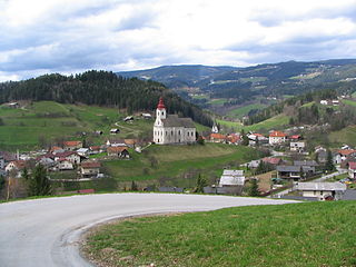
Šmartno pri Slovenj Gradcu is a settlement in the City Municipality of Slovenj Gradec in northern Slovenia. The area was traditionally part of Styria. The entire municipality is now included in the Carinthia Statistical Region.
Turiška Vas is a small village in the Mislinja Valley in the City Municipality of Slovenj Gradec in northern Slovenia. The area was traditionally part of Styria. The entire municipality is now included in the Carinthia Statistical Region.
Bukovska Vas is a settlement on the left bank of the Mislinja River in the Municipality of Dravograd in the Carinthia region in northern Slovenia. It includes the hamlet of Sveta Jedrt.
Otiški Vrh is a dispersed settlement in the hills southeast of Dravograd in the Styria region in northern Slovenia.
Selovec is a dispersed settlement in the hills south of Dravograd in the Carinthia region in northern Slovenia.
Šentjanž pri Dravogradu is a settlement on the left bank of the Mislinja River south of Dravograd in northern Slovenia, in the traditional region of Styria.
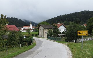
Šentilj pod Turjakom is a village in the Municipality of Mislinja in northern Slovenia. The area was part of the traditional region of Carinthia. It is now included in the Carinthia Statistical Region.
Dovže is a village in the Municipality of Mislinja in northern Slovenia. The area was traditionally part of Carinthia. It is now included in the Carinthia Statistical Region.

Gornji Dolič is a village in the Municipality of Mislinja in northern Slovenia. Traditionally the area was part of Carinthia and is now included in the Carinthia Statistical Region.
Kozjak is a dispersed settlement in the Municipality of Mislinja in northern Slovenia. Traditionally the area was part of Carinthia and is now included in the Carinthia Statistical Region.
Mala Mislinja is a dispersed settlement in the hills north of Mislinja in northern Slovenia. Traditionally the area was part of Carinthia. The entire Municipality of Mislinja is now included in the Carinthia Statistical Region.
Završe is a dispersed settlement in the Municipality of Mislinja in northern Slovenia. The area was traditionally part of Carinthia. It is now included in the Carinthia Statistical Region.