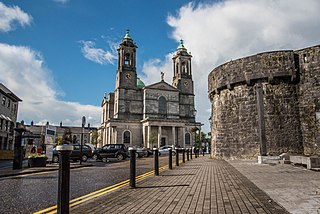
Athlone is a town on the border of County Roscommon and County Westmeath, Ireland. It is located on the River Shannon near the southern shore of Lough Ree. It is the second most populous town in the Midlands Region with a population of 22,869 in the 2022 census.
Mary O'Rourke is an Irish former Fianna Fáil politician who served as Leader of the Seanad and Leader of Fianna Fáil in the Seanad from 2002 to 2007, Deputy leader of Fianna Fáil from 1994 to 2002, Minister for Public Enterprise from 1997 to 2002, Minister for Health from 1991 to 1992 and Minister for Education from 1987 to 1991. She also served as a Minister of State from 1992 to 1994. She served as a Teachta Dála (TD) from 1982 to 2002 and 2007 to 2011. She served as a Senator for the Cultural and Educational Panel from 1981 to 1982 and from 2002 to 2007, after being Nominated by the Taoiseach.
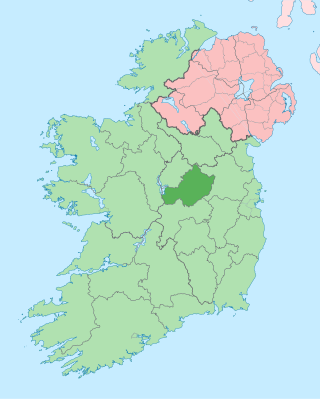
County Westmeath is a county in Ireland. It is in the province of Leinster and is part of the Eastern and Midland Region. It formed part of the historic Kingdom of Meath, which was named Mide because the kingdom was located in the geographical centre of Ireland. Westmeath County Council is the administrative body for the county, and the county town is Mullingar. At the 2022 census, the population of the county was 95,840.

Ballymahon on the River Inny is a town in the southern part of County Longford, Ireland. It is located at the junction of the N55 National secondary road and the R392 regional road.

Mullingar is the county town of County Westmeath in Ireland. It is the third most populous town in the Midland Region, with a population of 22,667 in the 2022 census.

Moate is a town in County Westmeath, Ireland.
Delvin is a village in County Westmeath, Ireland; it is located on the N52 road at a junction with the N51 to Navan. The town is 20 km (12 mi) from Mullingar.

Kinnegad or Kinagad is a town in County Westmeath, Ireland. It is on the border with County Meath, near the junction of the M6 and the M4 motorways - two of Ireland's main east–west roads. It is roughly 60 km from the capital, Dublin.
Raharney is a village in east County Westmeath, Ireland. It has a population of 221 according to the 2016 census.

The Diocese of Elphin is a Latin Church diocese of the Catholic Church in the western part of Ireland. It is in the Metropolitan Province of Tuam and is subject to the Metropolitan Archdiocese of Tuam. The current bishop is Kevin Doran who was appointed in 2014.

The Diocese of Ardagh and Clonmacnoise is a Latin Church diocese of the Catholic Church in Ireland.

Taghmaconnell or Taughmaconnell is a small village in County Roscommon, Ireland. It lies between Athlone and Ballinasloe. It is also the name of the parish in which the village lies.

The R446 road is a regional road in Ireland. The road connects Kinnegad in County Westmeath to Galway City. Prior to the construction of the M6 motorway the R446 formed the main N6 road connecting Dublin and Galway. Following the opening of the M6; the old N6 road was downgraded to regional road status and was designated as the R446. The road is an alternative route between Galway and Dublin and runs in parallel to the M6.

Ballymore is a village in County Westmeath, Ireland, on the R390 road between Athlone and Mullingar. The historic Hill of Uisneach is nearby. The village was known in medieval times as the medieval borough of Ballymore Lough Sewdy, or Loughsewdy, after the nearby lake, the site of an ancient bruighean, or hostel.

Mount Temple is a village in County Westmeath in Ireland, about 6.5 km northwest of Moate. It is noted for its golf course of the same name. It was historically called Ballyloughloe. Mount Temple and its 'sister' village, Baylin, form the only two in the parish of Ballyloughloe.

Ankers Bower is a townland and hill in St. Mary's civil parish in the barony of Brawny, County Westmeath, Ireland. It is partly within the former urban district of Athlone. The name may derive from John Ankers, who was vicar of St. Mary's in 1608.
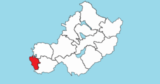
Brawny is a barony in south–west County Westmeath, Ireland. It was formed by 1672. It is bordered by County Roscommon to the west. It also borders two other Westmeath baronies: Kilkenny West and Clonlonan. The largest centre of population in the barony is the town of Athlone.
St. Marys is a civil parish in County Westmeath, Ireland. It is located about 38.96 kilometres (24 mi) west–south–west of Mullingar.

Baylin, also written Bealin is a village in County Westmeath, Ireland, about 5 kilometres (3.1 mi) east of Athlone. Its postal address is Baylin, Athlone, County Westmeath, Ireland.
Loughanaskin is a townland in Athlone, County Westmeath, Ireland. The townland is in the civil parish of St. Mary's.

