San Antonio, officially the City of San Antonio, is the seventh-most populous city in the United States, second largest city in the Southern United States, and the second-most populous city in Texas with 1,434,625 residents in 2020. Founded as a Spanish mission and colonial outpost in 1718, the city became the first chartered civil settlement in present-day Texas in 1731. The area was still part of the Spanish Empire, and later of the Mexican Republic. It is the state's oldest municipality, having celebrated its 300th anniversary on May 1, 2018.
Interstate 35 (I-35) is a major Interstate Highway in the central United States. As with most Interstates that end in a five, it is a major cross-country, north–south route. It stretches from Laredo, Texas, near the Mexican border to Duluth, Minnesota, at Minnesota State Highway 61 and 26th Avenue East. The highway splits into I-35E and I-35W in two separate places, the Dallas–Fort Worth metroplex in Texas and at the Minnesota twin cities of Minneapolis–Saint Paul.

KSAT-TV, virtual and VHF digital channel 12, is an ABC-affiliated television station licensed to San Antonio, Texas, United States. The station is owned by the Chicago-based Graham Media Group subsidiary of Graham Holdings Company. KSAT's studios are located on North St. Mary's Street on the northern edge of downtown, and its transmitter is located off Route 181 in northwest Wilson County.

Lake Street is a major east-west thoroughfare between 29th and 31st streets in Minneapolis, Minnesota United States. From its western most end at the city's limits, Lake Street reaches the Chain of Lakes, passing over a small channel linking Bde Maka Ska and Lake of the Isles, and at its eastern most end it reaches the Mississippi River. In May 2020, the Lake Street corridor suffered extensive damage during local unrest over the murder of George Floyd. In August of the same year, city officials designated East Lake Street as one of seven cultural districts to promote racial equity, preserve cultural identity, and promote economic growth.
Oklahoma City is near the geographic center of the United States and is an integral point on the U.S. Interstate Network. The city is served by numerous roads and highways, toll roads, three major airports, a train station, a bus station, and a transit system.

VIA Metropolitan Transit is the mass transit agency serving San Antonio, Texas, United States, and its surrounding municipalities. It began operation in 1978 as a successor to the San Antonio Transit System.
Texas State Highway 130 (SH 130), also known as the Pickle Parkway, is a highway from Interstate 35 (I-35) in San Antonio along I-410 and I-10 to east of Seguin, then north as tollway from there to I-35 north of Georgetown. SH 130 runs in a 91-mile (146 km) corridor east and south of Austin. The route parallels I-35 and is intended to relieve the Interstate's traffic volume through the San Antonio–Austin corridor by serving as an alternate route.
Interstate 10 (I-10) is the major east–west Interstate Highway in the Southern United States. In the U.S. state of Texas, it runs east from Anthony, at the border with New Mexico, through El Paso, San Antonio, and Houston to the border with Louisiana in Orange, Texas. At just under 880 mi (1,420 km), the Texas segment of I-10, maintained by the Texas Department of Transportation, is the longest continuous untolled freeway in North America that is operated by a single authority. It is also the longest stretch of Interstate Highway with a single designation within a single state. Mile marker 880 and its corresponding exit number in Orange, Texas, are the highest numbered mile marker and exit on any freeway in North America. After widening was completed in 2008, a portion of the highway west of Houston is now also believed to be the widest in the world, at 26 lanes when including feeders.

Streetcars or trolley(car)s were once the chief mode of public transit in hundreds of North American cities and towns. Most of the original urban streetcar systems were either dismantled in the mid-20th century or converted to other modes of operation, such as light rail. Today, only Toronto still operates a streetcar network essentially unchanged in layout and mode of operation.

Greater San Antonio, officially designated San Antonio–New Braunfels, is an eight-county metropolitan area in the U.S. state of Texas defined by the Office of Management and Budget (OMB). The metropolitan area straddles South Texas and Central Texas and is on the southwestern corner of the Texas Triangle. The official 2020 U.S. Census showed the metropolitan area's population at 2,558,143—up from a reported 1,711,103 in 2000—making it the 24th largest metropolitan area in the United States. Austin–Round Rock lies about 80 miles northeast of Greater San Antonio.

Mountain View Unit is a Texas Department of Criminal Justice prison housing female offenders in Gatesville, Texas. The unit, with about 97 acres (39 ha) of land, is located 4 miles (6.4 km) north of central Gatesville on Farm to Market Road 215. The prison is located in a 45-minute driving distance from Waco. In addition to its other functions, Mountain View Unit houses the state's female death row inmates.

The culture of San Antonio reflects the history and culture of one of the state's oldest and largest cities straddling the regional and cultural divide between South and Central Texas. Historically, San Antonio culture comes from a blend of Central Texas (Southern) and South Texas (Southwestern) culture. Founded as a Spanish outpost and the first civil settlement in Texas, San Antonio is heavily influenced by Mexican American culture due to Texas formerly being part of Mexico and, previously, the Spanish Empire. The city also has significant German, Anglo, and African American cultural influences. San Antonio offers a host of cultural institutions, events, restaurants and nightlife in South Texas for both residents and visitors alike.
The city of San Antonio in the U.S. state of Texas is composed of a number of neighborhoods and districts, spreading out surrounding the central Downtown Area.

U.S. Route 281 (US 281) is a United States Numbered Highway that runs from the Mexican border in the Rio Grande Valley to the Canadian border near Dunseith, North Dakota. In the state of Texas, the highway is a major south–north corridor, connecting Brownsville to the Oklahoma state line at the Red River in Burkburnett. Several segments of U.S. 281 are concurrent with Interstate routes, including I-69C in the Rio Grande Valley, I-37 in San Antonio, and I-44 north of Wichita Falls.
Wurzbach Parkway is a part freeway and part major arterial road in San Antonio, Texas, built to provide relief on Interstate 410 (I-410) and Loop 1604 on the city's north side. The highway is named for Harry M. Wurzbach, who represented the San Antonio area in Congress as a Republican in the 1920s and 1930s. The congressman's name was first applied to the connecting Wurzbach Road. The highway's western third was built as an expressway with at-grade intersections and the remainder as a freeway. The opening in September 2015 of an interchange with U.S. Highway 281 completed primary construction of the parkway. The highway, along with part of Wurzbach Road near the Ingram Park Mall, is maintained by the Texas Department of Transportation despite not carrying a state highway designation. Rather, it is being developed and maintained under the Principal Arterial State System (PASS) program, under which it is designated as PASS Project 1502. The parkway includes an interchange with US 281, and drivers can access I-10 and I-35 via local roads that extend the parkway.

Sun Metro Mass Transit Department, simply known as Sun Metro, is the public transportation provider that serves El Paso, Texas. Consisting of buses and paratransit service, it is a department of the City of El Paso, and the agency also serves the rest of El Paso County. The major hub is located at the Bert Williams Downtown Santa Fe Transfer Center in the surrounding block areas in Downtown El Paso.

Houston Street is one of San Antonio's oldest and most popular streets. Situated in the middle of the city's central business district, it is a major pedestrian thoroughfare and commercial district. Retail shops, chic restaurants, lofts, office space, and theaters line Houston from the Alamo to Santa Rosa, giving the street its famously eclectic and fashionable reputation.

35 Bar and Grille LLC, et al. v. The City of San Antonio was a court case in the U.S. District Court for the Western District of Texas. The case addressed a city ordinance about the amount of bodily coverage needed by semi-nude dancers in San Antonio, Texas. The case reached notoriety in international press when the press discovered that Chief U.S. District Judge Fred Biery's April 29, 2013 order denying a motion for a preliminary injunction was full of puns and double entendres about stripping and sexuality. During its press coverage, the case was also known by the humorous title applied to the judge's opinion of the case, The Itsy Bitsy Teeny Weeny Bikini Top v The (More) Itsy Bitsy Teeny Weeny Pastie.

The METRO A Line is a bus rapid transit line in the Twin Cities, Minnesota operated by Metro Transit. The A Line operates primarily along the Snelling Avenue corridor and travels through the cities of Minneapolis, Saint Paul, Falcon Heights, and Roseville. From the Blue Line in Minneapolis, the line travels past Minnehaha Park, through the Highland Village commercial area, past Macalester College, and connects to the Green Line near Allianz Field. The line continues through Saint Paul, past Hamline University, before traveling through Falcon Heights and Roseville, where the line passes the Minnesota State Fairgrounds, Har Mar Mall, and terminates at Rosedale Center.

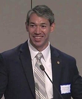
On May 6, 2017, the city of San Antonio, Texas held an election to choose the next mayor of San Antonio. As no candidate secured a majority of the vote, a runoff was held on June 10, 2017 with Councilman Ron Nirenberg defeating incumbent mayor Ivy Taylor.


