The Alps are the highest and most extensive mountain range system that lies entirely in Europe, separating Southern from Central and Western Europe and stretching approximately 1,200 kilometres (750 mi) across eight Alpine countries : France, Switzerland, Italy, Monaco, Liechtenstein, Austria, Germany, and Slovenia. The mountains were formed over tens of millions of years as the African and Eurasian tectonic plates collided. Extreme shortening caused by the event resulted in marine sedimentary rocks rising by thrusting and folding into high mountain peaks such as Mont Blanc and the Matterhorn. Mont Blanc spans the French–Italian border, and at 4,810 m (15,781 ft) is the highest mountain in the Alps. The Alpine region area contains about a hundred peaks higher than 4,000 metres (13,000 ft).

The Pennine Alps, also known as the Valais Alps, are a mountain range in the western part of the Alps. They are located in Switzerland (Valais) and Italy.

The Graian Alps are a mountain range in the western part of the Alps.

The main chain of the Alps, also called the Alpine divide is the central line of mountains that forms the water divide of the range. Main chains of mountain ranges are traditionally designated in this way, and generally include the highest peaks of a range; the Alps are something of an unusual case in that several significant groups of mountains are separated from the main chain by sizable distances. Among these groups are the Dauphine Alps, the Eastern and Western Graians, the entire Bernese Alps, the Tödi, Albula and Silvretta groups, the Ortler and Adamello ranges, and the Dolomites of South Tyrol, as well as the lower Alps of Vorarlberg, Bavaria and Salzburg.
This article lists the principal mountain passes and tunnels in the Alps, and gives a history of transport across the Alps.
Saint Bernard, St. Bernard, St Bernard or San Bernard may refer to:

The Engadin or Engadine is a long high Alpine valley region in the eastern Swiss Alps located in the canton of Graubünden in most southeastern Switzerland with about 25,000 inhabitants. It follows the route of the Inn from its headwaters at Maloja Pass in the southwest running roughly northeast until the Inn flows into Austria, one hundred kilometers downstream. The En/Inn subsequently flows at Passau into the Danube, as the only Swiss river to drain into the Black Sea. The Engadine is protected by high mountain ranges on all sides and is famous for its sunny climate, beautiful landscapes and outdoor activities.

The canton of Valais is one of the 26 cantons of Switzerland, situated in the southwestern part of the country, around the valley of the Rhône from its headwaters to Lake Geneva, separating the Pennine Alps from the Bernese Alps. The canton is simultaneously one of the driest regions of Switzerland in its central Rhône valley and among the wettest, having large amounts of snow and rain up on the highest peaks found in Switzerland. The canton of Valais is widely known for the Matterhorn and resort towns such as Crans-Montana, Saas Fee, Verbier and Zermatt. It is composed of 13 districts and its capital is Sion.

Aosta is the principal city of Aosta Valley, a bilingual region in the Italian Alps, 110 km (68 mi) north-northwest of Turin. It is situated near the Italian entrance of the Mont Blanc Tunnel, at the confluence of the Buthier and the Dora Baltea, and at the junction of the Great and Little St. Bernard routes.

The St. Bernard or St Bernard is a breed of very large working dog from the western Alps in Italy and Switzerland. They were originally bred for rescue by the hospice of the Great St Bernard Pass on the Italian-Swiss border. The hospice, built by and named after Italian monk Bernard of Menthon, acquired its first dogs between 1660 and 1670. The breed has become famous through tales of alpine rescues, as well as for its enormous size.

The Gotthard Pass or St. Gotthard Pass at 2,106 m (6,909 ft) is a mountain pass in the Alps traversing the Saint-Gotthard Massif and connecting northern and southern Switzerland. The pass lies between Airolo in the Italian-speaking canton of Ticino, and Andermatt in the German-speaking canton of Uri, and connects further Bellinzona to Lucerne, Basel, and Zurich. The Gotthard Pass lies at the hearth of the Gotthard, an important north-south axis in Europe, and is it crossed by three major traffic tunnels, each being the world's longest at the time of their construction: the Gotthard Rail Tunnel (1882), the Gotthard Road Tunnel (1980) and the Gotthard Base Tunnel (2016). With the Lötschberg to the west, the Gotthard is one of the two main north-south routes through the Swiss Alps. Since the Middle Ages, transit across the Gotthard played an important role in Swiss history, the region north of Gotthard becoming the nucleus of the Swiss Confederacy in the early 14th century.

The Bernina Pass is a high mountain pass in the Bernina Range of the Alps, in the canton of Graubünden (Grisons) in eastern Switzerland. It connects the famous resort town of St. Moritz in the Engadin valley with the Italian-speaking Val Poschiavo, which ends in the Italian town of Tirano in Valtellina. The pass lies a few kilometres east of Piz Bernina.

The Alps cover a large area. This article describes the delimitation of the Alps as a whole and of subdivisions of the range, follows the course of the main chain of the Alps and discusses the lakes and glaciers found in the region.

Alpes Poeninae [alˈpeːs ˈpoe̯nɪnae̯], also known as Alpes Graiae, was a small Alpine province of the Roman Empire, one of three such provinces in the western Alps between Italy and Gaul. It comprised the Val d'Aosta region (Italy) and the Canton Valais (Switzerland).
The Veragri were a Gallic tribe located in present-day Switzerland. The Veragri are placed by Julius Caesar in the canton of Valais between the Nantuates and the Seduni. Their chief town was Octodurus, whence the Veragri are called Octodurenses by Pliny. Dio Cassius, claiming Caesar as his source, says that the Veragri extended from the territory of the Allobroges and Lake Geneva to the Alps; which is likely not true. Strabo (iv.) mentions the "Varagri", as he calls them, between the Caturiges and the Nantuatae; and Pliny between the Seduni and the Salassi: the Salassi were on the Italian side of the Alps in the Val d'Aosta. Livy places the Veragri among the Alps and on the road to the pass of the Pennine Alps, or the Great St. Bernard Pass, which is correct. He says that the pass was occupied by "half German tribes", leaving the ethnic affiliation of the Veragri in some doubt.
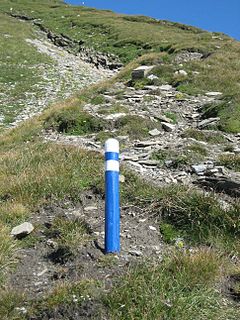
An alpine route is a trail or climbing route through difficult terrain in high mountains such as the Alps, sometimes with no obvious path. In the Alps, the Alpine clubs define and mark an Alpine Route, also called Alpinweg or Alpinwanderweg.
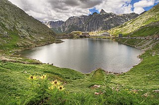
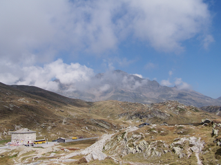
Great St Bernard Lake is a mountain lake of the Pennine Alps, located south-west of Great St Bernard Pass. It is divided between Switzerland and Italy, although it lies south of the Alps, within the Dora Baltea basin.